Country:
 Germany
Region:
City:
Latitude and Longitude:
Time Zone:
Postal Code:
IP information under different IP Channel
ip-api
Country
Region
City
ASN
Time Zone
ISP
Blacklist
Proxy
Latitude
Longitude
Postal
Route
IPinfo
Country
Region
City
ASN
Time Zone
ISP
Blacklist
Proxy
Latitude
Longitude
Postal
Route
MaxMind
Country
Region
City
ASN
Time Zone
ISP
Blacklist
Proxy
Latitude
Longitude
Postal
Route
Luminati
Country
DERegion
be
City
berlin
ASN
Time Zone
Europe/Berlin
ISP
iNES GROUP SRL
Latitude
Longitude
Postal
db-ip
Country
Region
City
ASN
Time Zone
ISP
Blacklist
Proxy
Latitude
Longitude
Postal
Route
ipdata
Country
Region
City
ASN
Time Zone
ISP
Blacklist
Proxy
Latitude
Longitude
Postal
Route
Popular places and events near this IP address

Berlin
Capital and largest city of Germany
Distance: Approx. 136 meters
Latitude and longitude: 52.52,13.405
Berlin is the capital and largest city of Germany, both by area and by population. Its more than 3.85 million inhabitants make it the European Union's most populous city, as measured by population within city limits. The city is also one of the states of Germany, and is the third smallest state in the country in terms of area.

East Berlin
Soviet sector of Berlin between 1948 and 1990
Distance: Approx. 199 meters
Latitude and longitude: 52.51861111,13.40444444
East Berlin (German: Ost-Berlin; pronounced [ˈɔstbɛʁˌliːn] ) was the partially recognised capital of East Germany (GDR) from 1949 to 1990. From 1945, it was the Soviet occupation sector of Berlin. The American, British, and French sectors were known as West Berlin.
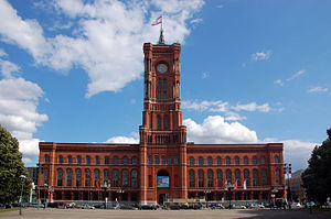
Rotes Rathaus
City hall of Berlin
Distance: Approx. 147 meters
Latitude and longitude: 52.51861111,13.40833333
The Rotes Rathaus (German: [ˈʁoːtəs ˈʁaːtˌhaʊs] , Red City Hall) is the town hall of Berlin, Germany, located in the Mitte district on Rathausstraße near Alexanderplatz. It is the home to the governing mayor and the government (the Senate of Berlin) of the state of Berlin. The name of the landmark building dates from the façade design with red clinker bricks.

Fernsehturm Berlin
Television tower in Berlin
Distance: Approx. 220 meters
Latitude and longitude: 52.52083333,13.40944444
The Fernsehturm (German: [ˈfɛʁnzeːˌtʊʁm] ; English: Television Tower) in central Berlin was constructed between 1965 and 1969 by the government of the German Democratic Republic, or East Germany, as both a functional broadcasting facility and a symbol of Communist power. It remains a landmark today from its position next to Alexanderplatz in the city's Marien Quarter, part of the district of Mitte, visible across most suburban districts of Berlin. With its height to 368 metres (1,207 ft) (including antenna) it is the tallest structure in Germany, and the third-tallest structure in the European Union.
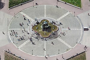
Neptunbrunnen (Berlin)
Distance: Approx. 2 meters
Latitude and longitude: 52.5196,13.40687
The Neptune Fountain (German: Neptunbrunnen) in Berlin was built in 1891 and was designed by Reinhold Begas. The Roman god Neptune is in the center. The four women around him represent the four main rivers of Prussia at the time the fountain was constructed: the Elbe (with the allegorical figure holding fruits and ears of corn), Rhine (fishnet and grapes), Vistula (wooden blocks, symbols of forestry), and Oder (goats and animal skins).

Karl-Liebknecht-Straße
Major street in the Berlin Mitte district
Distance: Approx. 200 meters
Latitude and longitude: 52.52138889,13.40722222
Karl-Liebknecht-Straße is a major street in the central Mitte district of the German capital Berlin. It is named after Karl Liebknecht (1871–1919), one of the founders of the Communist Party of Germany. The street connects the Unter den Linden boulevard with the Prenzlauer Allee arterial road leading to the northern city limits.

St. Mary's Church, Berlin
Church in Berlin, Germany
Distance: Approx. 108 meters
Latitude and longitude: 52.52055556,13.40666667
St. Mary's Church, known in German as the Marienkirche or St.-Marien-Kirche, is a church in Berlin, Germany. It is located on Karl-Liebknecht-Straße (formerly Kaiser-Wilhelm-Straße) in central Berlin, near Alexanderplatz.

Marx-Engels Forum
Park in Berlin, Germany
Distance: Approx. 233 meters
Latitude and longitude: 52.51833333,13.40416667
Marx-Engels-Forum is a public park in the central Mitte district of Berlin, the capital of Germany. It is named for Karl Marx and Friedrich Engels, authors of The Communist Manifesto of 1848 and regarded as two of the most influential people in the socialist movement. The park was created by the authorities of the former German Democratic Republic (GDR) in 1986.

Mitte (locality)
Quarter of Berlin in Germany
Distance: Approx. 23 meters
Latitude and longitude: 52.51944444,13.40666667
Mitte (German pronunciation: [ˈmɪtə] ; German for "middle" or "center") is a central section (Ortsteil) of Berlin, Germany, in the eponymous borough (Bezirk) of Mitte. Until 2001, it was itself an autonomous district. Mitte proper comprises the historic center of Old Berlin, with the medieval churches of St.
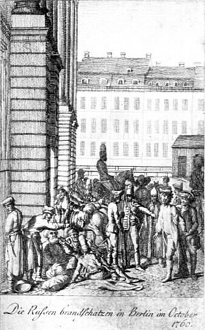
Raid on Berlin
1760 battle of the Third Silesian War
Distance: Approx. 138 meters
Latitude and longitude: 52.5186,13.4081
The Raid on Berlin took place in October 1760 during the Third Silesian War (part of the Seven Years' War) when Austrian and Russian forces occupied the Prussian capital of Berlin for several days. After raising money from the city, and with the approach of further Prussian reinforcements, the occupiers withdrew. There were later allegations that the Russian commander Count Tottleben had received a personal bribe from the Prussians to spare the city, and he was subsequently tried and found guilty of being a spy.

Rotes Rathaus (Berlin U-Bahn)
Station of the Berlin U-Bahn
Distance: Approx. 111 meters
Latitude and longitude: 52.518889,13.408056
Rotes Rathaus is a subway station in Berlin's Mitte district. It is part of the extension of the U5 from Alexanderplatz to Brandenburger Tor, construction of which began with a groundbreaking ceremony in 2010. The station and the line opened simultaneously on 4 December 2020.

Old Synagogue (Berlin)
Former synagogue in Berlin, Germany
Distance: Approx. 219 meters
Latitude and longitude: 52.5211,13.4048
The Old Synagogue (German: Alte Synagoge) was a Jewish congregation and synagogue, that was located at Heidereutergasse 4, in Marienviertel, in the present-day Mitte district of Berlin, Germany. Designed and built by Michael Kemmeter, the synagogue was built as a rectangular hall building. Consecrated in 1714 and remodelled in 1855, the synagogue was known as the Great Synagogue until the opening of the New Synagogue, built in the 1860s to accommodate Berlin's expanding Jewish population.
Weather in this IP's area
clear sky
32 Celsius
32 Celsius
31 Celsius
33 Celsius
1006 hPa
38 %
1006 hPa
1002 hPa
10000 meters
3.6 m/s
150 degree
06:29:31
19:38:47