Country:
 Netherlands
Region:
City:
Latitude and Longitude:
Time Zone:
Postal Code:
IP information under different IP Channel
ip-api
Country
Region
City
ASN
Time Zone
ISP
Blacklist
Proxy
Latitude
Longitude
Postal
Route
IPinfo
Country
Region
City
ASN
Time Zone
ISP
Blacklist
Proxy
Latitude
Longitude
Postal
Route
MaxMind
Country
Region
City
ASN
Time Zone
ISP
Blacklist
Proxy
Latitude
Longitude
Postal
Route
Luminati
Country
NLRegion
ut
City
utrecht
ASN
Time Zone
Europe/Amsterdam
ISP
Trans-iX B.V.
Latitude
Longitude
Postal
db-ip
Country
Region
City
ASN
Time Zone
ISP
Blacklist
Proxy
Latitude
Longitude
Postal
Route
ipdata
Country
Region
City
ASN
Time Zone
ISP
Blacklist
Proxy
Latitude
Longitude
Postal
Route
Popular places and events near this IP address

Oud-Zuilen
Village in Utrecht, Netherlands
Distance: Approx. 1624 meters
Latitude and longitude: 52.12722222,5.06944444
Oud-Zuilen is a village in the Dutch province of Utrecht. It is a part of the municipality of Stichtse Vecht, and lies about 4 km northwest of Utrecht. It is in an area called the "Vechtstreek".

Maarsseveen
Place in Utrecht, Netherlands
Distance: Approx. 2686 meters
Latitude and longitude: 52.14083333,5.07361111
Maarsseveen is a former hamlet in the Dutch province of Utrecht. It was located on the east bank of the Vecht River, opposite the village of Maarssen, and has now been completely absorbed by that town. It makes part of the municipality of Stichtse Vecht.

Zuilen
District of Utrecht, the Netherlands
Distance: Approx. 1625 meters
Latitude and longitude: 52.1272,5.0694
Zuilen is a district in the Northwest section of the Dutch city of Utrecht. Zuilen is bordered by the train line and the river Vecht, the Amsterdam-Rhine Canal, the street Marnixlaan, and the city borders at the north. The neighborhood Elinkwijk, located in Zuilen, contains the protected city view Beschermd Stadsgezicht Zuilen-Elinkwijk.

Oudegracht
Canal in Utrecht, Netherlands
Distance: Approx. 3002 meters
Latitude and longitude: 52.097,5.115
The Oudegracht, or "old canal", runs through the center of Utrecht, the Netherlands. It starts in the southeast of the city. Here the Kromme Rijn (the original main bed of the Rhine river) and the Vaartse Rijn (a medieval canal reconnecting Utrecht to the newer main stream of the Rhine, the Lek) arrive to meet the original moat of the fortified town, and the Oudegracht goes from there into the center of town.
Ondiep
Working-class district
Distance: Approx. 2204 meters
Latitude and longitude: 52.1,5.1
Ondiep is a working-class district in northwest Utrecht, Netherlands, between the river Vecht and Amsterdamsestraatweg street. Ondiep was constructed starting 1915. From the 1930, the district was used to house "abnormals", under the supervision of police, social work and medical workers.

Utrecht Overvecht railway station
Railway station in the Netherlands
Distance: Approx. 2686 meters
Latitude and longitude: 52.11,5.12527778
Utrecht Overvecht is a railway station located in Overvecht, Utrecht, Netherlands. The station opened in 1968 and is on the Utrecht–Kampen railway. The station has had 3 platforms since 1992.
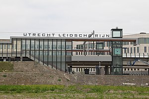
Utrecht Leidsche Rijn railway station
Railway station in the Netherlands
Distance: Approx. 2605 meters
Latitude and longitude: 52.09833333,5.06916667
Utrecht Leidsche Rijn is a railway station in west Utrecht, Netherlands. The station opened on 9 June 2013 and is located on the Utrecht–Rotterdam railway. The station is primarily for the housing areas, Parkwijk and Terwijde Oost.
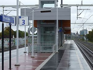
Utrecht Zuilen railway station
Railway station in the Netherlands
Distance: Approx. 1720 meters
Latitude and longitude: 52.10305556,5.08916667
Utrecht Zuilen is a railway station located in Utrecht, Netherlands. The station opened on 10 June 2007 and is located on the Amsterdam–Arnhem railway. The services are currently operated by Nederlandse Spoorwegen.

Jacobikerk
Distance: Approx. 3193 meters
Latitude and longitude: 52.095,5.11527778
The Jacobikerk is a landmark Protestant church in Utrecht, Netherlands. The building is located on the St Jacobsstraat, named for its patron saint St. James the Greater.

FC Utrecht (women)
Dutch women's football (soccer) club
Distance: Approx. 1509 meters
Latitude and longitude: 52.12041667,5.06663889
FC Utrecht Vrouwen is the women's football section of Dutch club FC Utrecht based in Utrecht. Established in 2007, as one of the founding members of the professional Dutch women's Eredivisie. The team competed in the Eredivisie from its inaugural season of 2007–08 until 2011–12 and then in the BeNe League, made of up Belgian and Dutch teams, from 2012–13 until the team's dissolution in January 2014.

Amsterdamsestraatweg Water Tower
Water tower in Utrecht, the Netherlands
Distance: Approx. 1782 meters
Latitude and longitude: 52.103,5.095
The Amsterdamsestraatweg Water Tower is located in Utrecht, the Netherlands. The water tower was built at Amsterdamsestraatweg 380 in 1916, in the style of the Amsterdam School. It became derelict in 1986 and was repeatedly squatted before its redevelopment into apartments began in 2020.
Academie Tien
School
Distance: Approx. 2807 meters
Latitude and longitude: 52.0956,5.0713
Academie Tien (stylized as ACADEMİE TİEN) is a Dutch secondary school located in the city of Utrecht. The school officially opened in 2015 as Mavo Tien, which only offered education to students in the MAVO level. On August 1, 2018, the school changed its name to Academie Tien and started enrolling students in the HAVO and VWO levels.
Weather in this IP's area
overcast clouds
14 Celsius
13 Celsius
13 Celsius
14 Celsius
1017 hPa
94 %
1017 hPa
1017 hPa
10000 meters
3.99 m/s
9.24 m/s
179 degree
100 %
08:13:38
18:34:49