Country:
 Romania
Region:
City:
Latitude and Longitude:
Time Zone:
Postal Code:
IP information under different IP Channel
ip-api
Country
Region
City
ASN
Time Zone
ISP
Blacklist
Proxy
Latitude
Longitude
Postal
Route
IPinfo
Country
Region
City
ASN
Time Zone
ISP
Blacklist
Proxy
Latitude
Longitude
Postal
Route
MaxMind
Country
Region
City
ASN
Time Zone
ISP
Blacklist
Proxy
Latitude
Longitude
Postal
Route
Luminati
Country
ROASN
Time Zone
Europe/Bucharest
ISP
Orange Romania S.A.
Latitude
Longitude
Postal
db-ip
Country
Region
City
ASN
Time Zone
ISP
Blacklist
Proxy
Latitude
Longitude
Postal
Route
ipdata
Country
Region
City
ASN
Time Zone
ISP
Blacklist
Proxy
Latitude
Longitude
Postal
Route
Popular places and events near this IP address

Căpușu Mare
Commune in Cluj, Romania
Distance: Approx. 7834 meters
Latitude and longitude: 46.78888889,23.29166667
Căpușu Mare (Hungarian: Magyarkapus; ‹See Tfd›German: Grossthoren) is a commune in Cluj County, Transylvania, Romania, located 27 km (17 mi) west of the city of Cluj-Napoca. It is composed of nine villages: Agârbiciu (Egerbegy), Bălcești (Balkujtelep), Căpușu Mare, Căpușu Mic (Magyarkiskapus), Dângău Mare (Bánffydongó), Dângău Mic (Gyerőfidongó), Dumbrava (Gyerővásárhely), Păniceni (Gyerőfalva), and Straja (Gesztrágy).

Gilău, Cluj
Commune in Cluj, Romania
Distance: Approx. 2692 meters
Latitude and longitude: 46.75,23.38333333
Gilău (Hungarian: Gyalu; ‹See Tfd›German: Julmarkt or Gela) is a commune in Cluj County, Transylvania, Romania. It is made up of three villages: Gilău, Someșu Cald (Melegszamos), and Someșu Rece (Hidegszamos).
Agârbiciu (river)
River in Cluj County, Romania
Distance: Approx. 2100 meters
Latitude and longitude: 46.735,23.329
The Agârbiciu is a left tributary of the Someșul Cald in Romania. It discharges into the Someșul Cald Reservoir near the village Someșu Cald. Its length is 13 km (8.1 mi) and its basin size is 26 km2 (10 sq mi).

Someșul Cald
River in Cluj County, Romania
Distance: Approx. 671 meters
Latitude and longitude: 46.739,23.362
The Someșul Cald (Hungarian: Meleg-Szamos; literally "Warm Someș") is the left headwater of the river Someșul Mic in Romania. It joins the Someșul Rece in Lake Gilău, a reservoir near Gilău. The reservoirs Mărișelu, Tarnița and Someșul Cald are located on this river.

Căpuș
River in Cluj County, Romania
Distance: Approx. 3583 meters
Latitude and longitude: 46.7535,23.3942
The Căpuș (Hungarian: Kapus) is a left tributary of the river Someșul Mic in Romania. It discharges into the Someșul Mic in Gilău. Its length is 32 km (20 mi) and its basin size is 142 km2 (55 sq mi).
Râșca Mare
River in Cluj County, Romania
Distance: Approx. 6141 meters
Latitude and longitude: 46.6913,23.3061
The Râșca Mare is a right tributary of the river Someșul Rece in Romania. It discharges into the Someșul Rece downstream from the Cheile de la Arsuri, near Gilău. Its length is 12 km (7.5 mi) and its basin size is 18 km2 (6.9 sq mi).
Someșul Rece
Right headwater of the river Someșul Mic in Romania
Distance: Approx. 160 meters
Latitude and longitude: 46.73556,23.35752
The Someșul Rece (Hungarian: Hideg-Szamos; literally "Cold Someș") is the right headwater of the river Someșul Mic in Romania. It joins the Someșul Cald (Warm Someș) in Lake Tarnița, a reservoir near Gilău. Its length is 49 km (30 mi) and its basin size is 330 km2 (130 sq mi).
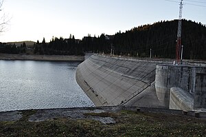
Mărișelu Hydroelectric Power Station
Dam in Mărișel, Cluj County
Distance: Approx. 495 meters
Latitude and longitude: 46.73216667,23.35080556
Mărişelu Hydro Power Plant is a large power plant on the Someșul Cald river situated in Romania. The project was started and finished in the 1970s and it was made up by the construction of a rockfill dam 92 metres (302 ft) high and 410 m (1,350 ft) long at the top. From the reservoir, the water is diverted through a 8.475 km (5.266 mi) tunnel to the plant.
Râșca (Someș)
River in Cluj County, Romania
Distance: Approx. 6987 meters
Latitude and longitude: 46.7182,23.268
The Râșca is a left tributary of the river Someșul Cald in Romania. It discharges into the Lake Tarnița, which is drained by the Someșul Cald. Its length is 20 km (12 mi) and its basin size is 59 km2 (23 sq mi).
Tarnița – Lăpuștești Hydroelectric Power Station
Dam in Râșca, Cluj County
Distance: Approx. 7081 meters
Latitude and longitude: 46.71388889,23.26861111
The Tarnița–Lăpuștești Hydropower Plant is a proposed hydroelectric pumped-storage project on the Someșul Cald River in Cluj County, Romania. If built it would be the largest hydro-electric load balancing system in Romania. During the night, when the demand is low and electricity is cheap because of powerplants which generate electricity continuously, such as the Cernavodă nuclear power plant, it will use electricity to pump water up the hill, while during the day, it will use the hydro energy to generate electricity.

Ulpianum (castra)
Fort in the Roman province of Dacia
Distance: Approx. 2692 meters
Latitude and longitude: 46.75,23.38333333
Ulpianum was a fort in the Roman province of Dacia. Traces of the castra built in the 2nd century AD can be identified at the confluence of the rivers Someșul Mic and Căpuş in the Bánffy Castle's park at Gilău (Romania). A vicus developed south and west of the fort.

Lake Tarnița
Artificial lake in Romania
Distance: Approx. 6163 meters
Latitude and longitude: 46.72111111,23.27805556
Lake Tarnița (Romanian: Lacul Tarnița) is a reservoir located in Cluj County, Romania, between the communes of Râșca, Mărișel, and Gilău, west of Cluj-Napoca. Covering some 215 ha (530 acres), with a length of close to 9 km (5.6 mi) and a maximum depth of over 70 m (230 ft), it is a popular tourist destination. Water from the Someșul Cald River flows into the reservoir.
Weather in this IP's area
overcast clouds
16 Celsius
15 Celsius
15 Celsius
16 Celsius
1010 hPa
46 %
1010 hPa
959 hPa
10000 meters
1.56 m/s
4.04 m/s
127 degree
98 %
07:28:02
19:02:49