Country:
 Romania
Region:
City:
Latitude and Longitude:
Time Zone:
Postal Code:
IP information under different IP Channel
ip-api
Country
Region
City
ASN
Time Zone
ISP
Blacklist
Proxy
Latitude
Longitude
Postal
Route
IPinfo
Country
Region
City
ASN
Time Zone
ISP
Blacklist
Proxy
Latitude
Longitude
Postal
Route
MaxMind
Country
Region
City
ASN
Time Zone
ISP
Blacklist
Proxy
Latitude
Longitude
Postal
Route
Luminati
Country
ROASN
Time Zone
Europe/Bucharest
ISP
Orange Romania S.A.
Latitude
Longitude
Postal
db-ip
Country
Region
City
ASN
Time Zone
ISP
Blacklist
Proxy
Latitude
Longitude
Postal
Route
ipdata
Country
Region
City
ASN
Time Zone
ISP
Blacklist
Proxy
Latitude
Longitude
Postal
Route
Popular places and events near this IP address

Constanța
Coastal city in Constanța County, Romania
Distance: Approx. 1204 meters
Latitude and longitude: 44.16666667,28.63333333
Constanța (UK: , US: ; Romanian: [konˈstantsa] ; Aromanian: Custantsa; Bulgarian: Кюстенджа, romanized: Kyustendzha, or Констанца, Konstantsa; Dobrujan Tatar: Köstencĭ; Greek: Κωνστάντζα, romanized: Kōnstántza, or Κωνστάντια, Kōnstántia; Turkish: Köstence), historically known as Tomis or Tomi (Ancient Greek: Τόμις or Τόμοι), is a port city in the Dobruja historical region of Romania. As the country's fourth largest city and principal port on the Black Sea coast, Constanța is the capital of Constanța County. It is also the oldest continuously inhabited city in the region, founded around 600 BC, and among the oldest in Europe.
Ovidius High School
School in Constanța, Constanța County, Romania
Distance: Approx. 782 meters
Latitude and longitude: 44.17166667,28.63527778
Ovidius High School (Romanian: Liceul Teoretic "Ovidius") is a public high school located at 2, Basarabi Alley, Constanța, Romania. It was founded on 27 May 1955, by its first director, Alexandru Ștefănescu.
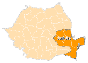
Sud-Est (development region)
Region in Romania
Distance: Approx. 1204 meters
Latitude and longitude: 44.16666667,28.63333333
Sud-Est (English South East) is a development region in Romania. As with other development regions, it does not have any administrative powers, its main function being to co-ordinate regional development projects and manage funds from the European Union.

Mircea cel Bătrân Naval Academy
Naval academy for the Romanian Naval Forces
Distance: Approx. 1070 meters
Latitude and longitude: 44.18361111,28.61916667
The Mircea cel Bătrân Naval Academy (Romanian: Academia Navală „Mircea cel Bătrân") is a higher education institution based in the Black Sea port of Constanța that educates future officers for the Romanian Naval Forces, as well as maritime officers and engineers for the merchant marine. At the request of the Romanian Coast Guard, the Naval Academy prepares coast guard officers.

Mihai Eminescu National College (Constanța)
Public school in Constanța, Constanța County, Romania
Distance: Approx. 2116 meters
Latitude and longitude: 44.174676,28.65521
Mihai Eminescu National College (Romanian: Colegiul Național "Mihai Eminescu") is a high-school located at 19 Traian Street in Constanța, Romania.
Port of Constanța
Port in Romania
Distance: Approx. 857 meters
Latitude and longitude: 44.17333333,28.63833333
The Port of Constanța is located in Constanța, Romania, on the western coast of the Black Sea, 179 nautical miles (332 km) from the Bosphorus Strait and 85 nmi (157 km) from the Sulina Branch, through which the Danube river flows into the sea. It covers 3,926 ha (9,700 acres), of which 1,313 ha (3,240 acres) is land and the rest, 2,613 ha (6,460 acres) is water. The two breakwaters located northwards and southwards shelter the port, creating the safest conditions for port activities.

Tomis (castra)
Distance: Approx. 2245 meters
Latitude and longitude: 44.17548,28.656934
Tomis was a Roman fort in the ancient city of Tomis (Constanța) in the Roman province of Moesia. According to the Tabula Peutingeriana it is situated between Stratonis and Histriopolis.

Hünkar Mosque, Constanța
Mosque in Constanța, Romania
Distance: Approx. 2092 meters
Latitude and longitude: 44.17560289,28.6550257
The Hünkar Mosque (Romanian: Geamia Hunchiar; Turkish: Hünkar Camii, lit. "Sovereign's Mosque") is a mosque located at 41 Tomis Boulevard, Constanța, Romania. The mosque was completed in 1869, nine years before Northern Dobruja became part of Romania, during the reign of Ottoman Sultan Abdulaziz.

Great Synagogue (Constanța)
Former synagogue in Constanța, Romania
Distance: Approx. 2234 meters
Latitude and longitude: 44.1745,28.65666667
The Great Synagogue of Constanța is a synagogue, located at 2 C. A. Rosetti Street in Constanța, Romania, that is no longer in use. Although it is in an advanced state of decay and has been abandoned, it is the only synagogue that stands in Constanța.

Greek Church (Constanța)
Heritage site in Constanța County, Romania
Distance: Approx. 2182 meters
Latitude and longitude: 44.17711,28.65623
The Greek Church is a Romanian Orthodox church located at 36 Mircea cel Bătrân Street, Constanța, Romania. It is dedicated to the Feast of the Transfiguration. The oldest church in Constanța, it was built between 1865 and 1867, following a firman issued by Ottoman Sultan Abdulaziz.
Dormition of the Theotokos Church, Constanța
Orthodox church in Constanța, Romania
Distance: Approx. 1499 meters
Latitude and longitude: 44.17924,28.64741
The Dormition of the Theotokos Church (Romanian: Biserica Adormirea Maicii Domnului) is a Romanian Orthodox church located at 18 Ion Lahovary Street, Constanța, Romania. It is dedicated to the Dormition of the Theotokos. The building is the city's second-oldest Romanian church, after what is now the cathedral.
Constanța hospital fire
2021 fire in Constanța, Romania
Distance: Approx. 975 meters
Latitude and longitude: 44.17118056,28.63803056
On 1 October 2021, at around 09:48 EET, a fire was reported to have started in the Constanța Hospital for Infectious Diseases at Constanța, Romania.
Weather in this IP's area
broken clouds
22 Celsius
22 Celsius
22 Celsius
23 Celsius
1014 hPa
60 %
1014 hPa
1009 hPa
10000 meters
6.29 m/s
6.85 m/s
174 degree
57 %
07:05:39
18:43:02