Country:
Region:
City:
Latitude and Longitude:
Time Zone:
Postal Code:
IP information under different IP Channel
ip-api
Country
Region
City
ASN
Time Zone
ISP
Blacklist
Proxy
Latitude
Longitude
Postal
Route
Luminati
Country
ASN
Time Zone
Europe/Bucharest
ISP
Orange Romania S.A.
Latitude
Longitude
Postal
IPinfo
Country
Region
City
ASN
Time Zone
ISP
Blacklist
Proxy
Latitude
Longitude
Postal
Route
db-ip
Country
Region
City
ASN
Time Zone
ISP
Blacklist
Proxy
Latitude
Longitude
Postal
Route
ipdata
Country
Region
City
ASN
Time Zone
ISP
Blacklist
Proxy
Latitude
Longitude
Postal
Route
Popular places and events near this IP address

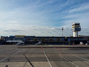
Timișoara Traian Vuia International Airport
Airport in Ghiroda, Timiș County
Distance: Approx. 3036 meters
Latitude and longitude: 45.81,21.33805556
Timișoara Traian Vuia International Airport (IATA: TSR, ICAO: LRTR) is an international airport serving Timișoara, Romania. Located in the historical region of Banat, the airport is named in honor of Traian Vuia, a Romanian flight pioneer and a Timiș County native. It is the fourth-busiest Romanian airport in terms of air traffic and the main air transportation hub for the western part of Romania and for the Danube–Criș–Mureș–Tisa Euroregion.

RoAF 93rd Air Base
Distance: Approx. 2905 meters
Latitude and longitude: 45.81,21.33399722
The Romanian Air Force 93rd Air Base (Romanian: Baza 93 Aeriană), also known as Giarmata Air Base, was an air base located in the commune Giarmata, near Timișoara, at the Traian Vuia International Airport. The base was disbanded in August 2004 due to the Romanian Armed Forces reorganisation program and the retirement of the MiG-23s which were based here. The military sector of the Traian Vuia International Airport is currently an annex of the 71st Air Base hosting the 712th Helicopter Squadron (operating IAR-330M).

Dumbrăvița, Timiș
Commune in Timiș, Romania
Distance: Approx. 6632 meters
Latitude and longitude: 45.8,21.25
Dumbrăvița (Hungarian: Újszentes, until 1906 Vadászerdő; German: Neusentesch; formerly Uisenteș and Sintești) is a commune in Timiș County, Romania. It is composed of a single village, Dumbrăvița. One of the most developed and rich communes in Romania, Dumbrăvița has become in recent years a suburb of Timișoara.

Giarmata
Commune in Timiș, Romania
Distance: Approx. 276 meters
Latitude and longitude: 45.83333333,21.31666667
Giarmata (Romanian pronunciation: [ˈdʒjarmata]; until 1925 Iermata Timișană; Hungarian: Temesgyarmat; German: Jahrmarkt) is a commune in Timiș County, Romania. It is composed of two villages, Cerneteaz and Giarmata (commune seat).

Remetea Mare
Commune in Timiș, Romania
Distance: Approx. 7498 meters
Latitude and longitude: 45.78333333,21.38333333
Remetea Mare (formerly Remetea Timișană; Hungarian: Temesremete; German: Großeinsiedel or Großremete) is a commune in Timiș County, Romania. It is composed of two villages, Ianova and Remetea Mare (commune seat).

Pișchia
Commune in Timiș, Romania
Distance: Approx. 7397 meters
Latitude and longitude: 45.9,21.33333333
Pișchia (Hungarian: Hidasliget or Piski; German: Bruckenau) is a commune in Timiș County, Romania. It is composed of five villages: Bencecu de Jos, Bencecu de Sus, Murani, Pișchia (commune seat) and Sălciua Nouă.
Stadionul Fortuna
Distance: Approx. 7281 meters
Latitude and longitude: 45.83916667,21.22638889
Fortuna Stadium is a multi-use stadium in Covaci, Timiș County. It is the home ground of Fortuna Covaci. It holds 1,500 people all on seats.
Timișoara Zoological Garden
Zoo in Romania
Distance: Approx. 7104 meters
Latitude and longitude: 45.7817709,21.2678146
Timișoara Zoological Garden (Romanian: Grădina Zoologică Timișoara) was a 6.34-hectare (15.7-acre) zoo in Timișoara, Romania, located in the northeastern part of the city, near the Green Forest. It was originally opened in 1986 with 30 species of animals, mostly local to Romania.
Revolution Festival
Romanian music festival
Distance: Approx. 7474 meters
Latitude and longitude: 45.7787,21.2658
Revolution (Romanian: Revolușn) was a summer music festival which is held in the city of Timișoara, Romania. The festival was founded in 2015 in Timișoara as a part of the EXIT Festival's EXIT Adventure package, which also contained EXIT and Sea Dance Festivals. The first edition of the festival was held from 30 to 31 May in Timișoara, and it attracted 12,000 visitors.

Green Forest, Timișoara
Romanian urban forest
Distance: Approx. 6660 meters
Latitude and longitude: 45.78829167,21.26496389
The Green Forest (in Romanian Pădurea Verde, in Hungarian Vadászerdő, in German Jagdwald, the last two translated as "hunting forest") is an urban forest located in northeastern Timișoara, covering an area of 724 ha (or 737 ha according to other sources). It is seen as Timișoara's green lung and is also an important recreation and leisure area.

Banat Village Museum
Open-air ethnographic museum in Timiș, Romania
Distance: Approx. 7605 meters
Latitude and longitude: 45.77720833,21.26595
The Banat Village Museum (Romanian: Muzeul Satului Bănățean) is an open-air ethnographic museum in northeastern Timișoara, at the edge of the Green Forest. Spread over an area of 17 ha, the museum is designed as a traditional Banat village and includes peasant households belonging to various ethnic groups in Banat (Romanians, Slovaks, Swabians, Ukrainians, Hungarians, etc.), buildings with social function of the traditional village (town hall, school, church, etc.), folk art installations and workshops.

Topla wooden church
Heritage site in Timiș County, Romania
Distance: Approx. 7556 meters
Latitude and longitude: 45.77805556,21.26527778
Topla wooden church is currently located in the premises of the Banat Village Museum in Timișoara, Romania. It is registered in the list of historical monuments (2004) with the code TM-II-m-A-06093.
Weather in this IP's area
clear sky
13 Celsius
12 Celsius
12 Celsius
13 Celsius
997 hPa
59 %
997 hPa
985 hPa
10000 meters
8.94 m/s
180 degree
07:42:02
16:59:07