Country:
 Bulgaria
Region:
City:
Latitude and Longitude:
Time Zone:
Postal Code:
IP information under different IP Channel
ip-api
Country
Region
City
ASN
Time Zone
ISP
Blacklist
Proxy
Latitude
Longitude
Postal
Route
IPinfo
Country
Region
City
ASN
Time Zone
ISP
Blacklist
Proxy
Latitude
Longitude
Postal
Route
MaxMind
Country
Region
City
ASN
Time Zone
ISP
Blacklist
Proxy
Latitude
Longitude
Postal
Route
Luminati
Country
BGRegion
01
City
razlog
ASN
Time Zone
Europe/Sofia
ISP
A1 Bulgaria EAD
Latitude
Longitude
Postal
db-ip
Country
Region
City
ASN
Time Zone
ISP
Blacklist
Proxy
Latitude
Longitude
Postal
Route
ipdata
Country
Region
City
ASN
Time Zone
ISP
Blacklist
Proxy
Latitude
Longitude
Postal
Route
Popular places and events near this IP address

Bansko
Place in Blagoevgrad, Bulgaria
Distance: Approx. 6650 meters
Latitude and longitude: 41.83333333,23.5
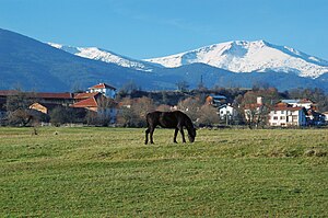
Bansko (Bulgarian: Банско [ˈbansko]) is a town in southwestern Bulgaria, located in Blagoevgrad Oblast near the city of Razlog. Once mainly a stockbreeding and travelling merchant community, the town is now an international centre for winter and summer tourism. More recently Bansko has become a known hotspot for digital nomads driven in part by the relative affordability of the location combined with its natural scenery.

Razlog
Town in Blagoevgrad, Bulgaria
Distance: Approx. 1456 meters
Latitude and longitude: 41.88333333,23.46666667
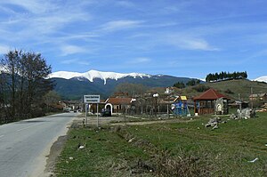
Razlog (Bulgarian: Разлог [rɐzˈɫɔk]) is a town and ski resort in Razlog Municipality, Blagoevgrad Province in southwestern Bulgaria.

Razlog Valley
Valley in Bulgaria
Distance: Approx. 3179 meters
Latitude and longitude: 41.86666667,23.5
The Razlog Valley (Bulgarian: Разложка котловина, romanized: Razlozhka kotlovina) is a valley in southwestern Bulgaria, Blagoevgrad Province, the municipalities of Razlog, Bansko and Belitsa. It is located between the mountains of Rila to the north and northwest, Pirin to the south and southwest, and the Rhodope Mountains to the east. The transitional continental mediterranean climate and nature of the valley are influenced by both the high alpine mountain “walls” of Rila and Pirin and the vast and wild Rhodopes, and the warm Mediterranean climate of the Aegean Sea entering from the south via the Mesta river course.

Bansko Municipality
Municipality in Blagoevgrad, Bulgaria
Distance: Approx. 6457 meters
Latitude and longitude: 41.83333333,23.48333333
Bansko Municipality (Bulgarian: Община Банско, romanized: Obshtina Bansko) is situated in southwestern Bulgaria and is one of the municipalities of Blagoevgrad Province.

Razlog Municipality
Municipality in Blagoevgrad, Bulgaria
Distance: Approx. 1456 meters
Latitude and longitude: 41.88333333,23.46666667
Razlog Municipality is located in Blagoevgrad Province, Bulgaria. It has 22,124 inhabitants. The town of Razlog is the administrative centre.
Banya, Blagoevgrad Province
Village in Blagoevgrad Province, Bulgaria
Distance: Approx. 3806 meters
Latitude and longitude: 41.88111111,23.52444444
Banya is a village in Razlog Municipality, in Blagoevgrad Province, Bulgaria, laying 4 km to the east of the town of Razlog and at about the same distance to the north of the ski resort of Bansko. Banya was first settled by the Thracians around the 4th century BC because of its thermal springs. Its mineral waters source at temperature ranging between 37 and 57 degrees Celsius are used for spa, recreational and industrial purposes.

Bachevo
Village in Blagoevgrad Province, Bulgaria
Distance: Approx. 3795 meters
Latitude and longitude: 41.91666667,23.45
Village of Bachevo is located in South-Western planning region of Bulgaria. It is part of Razlog Municipality, Blagoevgrad Province. Situated at South-western Bulgaria in the Razlog Valley (6 km.
Dolno Draglishte
Village in Blagoevgrad Province, Bulgaria
Distance: Approx. 5552 meters
Latitude and longitude: 41.93333333,23.51666667
Dolno Draglishte is a village in Razlog Municipality, in Blagoevgrad Province, Bulgaria.
Godlevo
Village in Blagoevgrad Province, Bulgaria
Distance: Approx. 4685 meters
Latitude and longitude: 41.93333333,23.48333333
Godlevo is a village in Razlog Municipality, in Blagoevgrad Province, Bulgaria. Godlevo is 12 kilometers from Bansko, 6 kilometers from Pirin Golf Country Club, 10 kilometers from Semkovo (ski center), and 140 kilometers from Sofia. Godlevo has its own stadium with capacity for 2000 people.
Gorno Draglishte
Village in Blagoevgrad Province, Bulgaria
Distance: Approx. 7185 meters
Latitude and longitude: 41.95,23.51666667
Gorno Draglishte is a village in Razlog Municipality, in Blagoevgrad Province, Bulgaria. This small mountain village at the foot of the Rila Mountain is surrounded by the Pirin and the Rhodopes. Gorno Draglishte is becoming a tourist attraction for both Bulgarians and foreigners.
Iztok (river)
River in south-western Bulgaria
Distance: Approx. 7197 meters
Latitude and longitude: 41.9,23.56666667
The Iztok (Bulgarian: Изток) is a river in south-western Bulgaria, a right tributary of the Mesta. The river is 16.5 km long and drains part of the northeastern sections of the Pirin mountain range. The Iztok takes its source from the Izvoro karst spring in the northern slopes of Pirin.

Glazne
River in south-western Bulgaria
Distance: Approx. 4964 meters
Latitude and longitude: 41.895,23.5403
The Glazne (Bulgarian: Глазне) is a river in south-western Bulgaria, a right tributary of the Iztok, itself a right tributary of the river Mesta. The river is 11 km long and drains parts of the northeastern slopes of the Pirin mountain range. The river takes its source from the confluence of the rivers Banderitsa (13 km, left) and Demyanitsa (13.6 km, right) at an altitude of 1,063 m, At 400 m southwest of the town of Bansko.
Weather in this IP's area
clear sky
21 Celsius
20 Celsius
21 Celsius
21 Celsius
1019 hPa
57 %
1019 hPa
928 hPa
10000 meters
0.68 m/s
2.38 m/s
236 degree
10 %
06:59:21
19:48:23