Country:
Region:
City:
Latitude and Longitude:
Time Zone:
Postal Code:
IP information under different IP Channel
ip-api
Country
Region
City
ASN
Time Zone
ISP
Blacklist
Proxy
Latitude
Longitude
Postal
Route
Luminati
Country
Region
112
City
aizpute
ASN
Time Zone
Europe/Riga
ISP
SIA Tet
Latitude
Longitude
Postal
IPinfo
Country
Region
City
ASN
Time Zone
ISP
Blacklist
Proxy
Latitude
Longitude
Postal
Route
db-ip
Country
Region
City
ASN
Time Zone
ISP
Blacklist
Proxy
Latitude
Longitude
Postal
Route
ipdata
Country
Region
City
ASN
Time Zone
ISP
Blacklist
Proxy
Latitude
Longitude
Postal
Route
Popular places and events near this IP address
Aizpute
Town in Latvia
Distance: Approx. 349 meters
Latitude and longitude: 56.71666667,21.6
Aizpute (German: Hasenpoth; historically Polish: Hazenpot) is a town in western Latvia's South Kurzeme Municipality in the valley of the Tebra River, situated 50 km (31 mi) northeast of Liepāja.
Kazdanga Palace
Palace in Latvia
Distance: Approx. 8225 meters
Latitude and longitude: 56.73388889,21.7325
Kazdanga Palace is located in the village Kazdanga (Polish and German Katzdangen), Kazdanga Parish, South Kurzeme Municipality, Latvia. The first manor house was made out of wood and the new palace was built in 1800–1804 in the late classical style, designed according to the project by the German architect J. G. Berlitz. Kazdanga established the first Latvian fish pond, now in operation for a number of important agricultural schools.

Boja Manor
Manor house in Latvia
Distance: Approx. 5724 meters
Latitude and longitude: 56.67913889,21.65763889
Boja Manor (Latvian: Boju muižas pils) is a manor house in Kazdanga Parish, South Kurzeme Municipality, in the historical region of Courland, in western Latvia.

Aizpute Municipality
Municipality of Latvia
Distance: Approx. 349 meters
Latitude and longitude: 56.71666667,21.6
Aizpute Municipality (Latvian: Aizputes novads) is a former municipality in Courland, Latvia. The municipality was formed in 2009 by merging Aizpute town, Aizpute parish, Cīrava parish, Kalvene parish, Kazdanga parish and Laža parish the administrative centre being Aizpute. Aizpute Municipality ceased to exist on 1 July 2021, when it was merged into the newly formed South Kurzeme Municipality.

Aizpute Castle
Castle ruin in Latvia
Distance: Approx. 342 meters
Latitude and longitude: 56.72102778,21.59516667
Aizpute Castle (German: Ordensburg Hasenpoth) is a Livonian Order castle in the town of Aizpute in the historical region of Courland, in western Latvia. It was heavily damaged during the Second Northern War (1655–1660). Since 1998, the castle ruins are a Latvian historical monument.
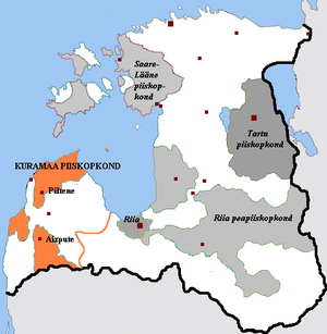
District of Pilten
Distance: Approx. 349 meters
Latitude and longitude: 56.71666667,21.6
The District of Pilten (Polish: Powiat piltyński, German: Kreis Pilten) was an autonomous district of the Polish–Lithuanian Commonwealth and also in union with the Duchy of Courland and Semigallia.
Kazdanga
Distance: Approx. 8275 meters
Latitude and longitude: 56.73222,21.73389
Kazdanga (German: Katzdangen) is a larger village, the administrative center of the Kazdanga Parish, South Kurzeme Municipality, Latvia. As of 2022 its population is 527. It is located in the northern part of the parish on the banks of the Alokste river, which is dammed within the extents of the village to form an artificial reservoir known as the Kazdanga Mill Lake (Kazdangas dzirnavezers) by which there is a water mill.
Weather in this IP's area
overcast clouds
8 Celsius
4 Celsius
8 Celsius
8 Celsius
990 hPa
66 %
990 hPa
983 hPa
10000 meters
5.91 m/s
10.65 m/s
269 degree
87 %
08:20:31
16:17:26


