84.201.96.25 - IP Lookup: Free IP Address Lookup, Postal Code Lookup, IP Location Lookup, IP ASN, Public IP
Country:
 Germany
Region:
City:
Location:
Time Zone:
Postal Code:
ISP:
ASN:
language:
User-Agent:
Proxy IP:
Blacklist:
IP information under different IP Channel
ip-api
Country
Region
City
ASN
Time Zone
ISP
Blacklist
Proxy
Latitude
Longitude
Postal
Route
db-ip
Country
Region
City
ASN
Time Zone
ISP
Blacklist
Proxy
Latitude
Longitude
Postal
Route
IPinfo
Country
Region
City
ASN
Time Zone
ISP
Blacklist
Proxy
Latitude
Longitude
Postal
Route
IP2Location
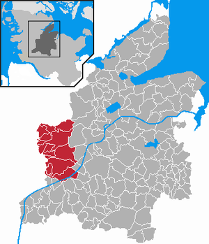
84.201.96.25Country
deRegion
schleswig-holstein
City
lohe
Time Zone
Europe/Berlin
ISP
Language
User-Agent
Latitude
Longitude
Postal
ipdata
Country
Region
City
ASN
Time Zone
ISP
Blacklist
Proxy
Latitude
Longitude
Postal
Route
Popular places and events near this IP address

Fockbek
Municipality in Schleswig-Holstein, Germany
Distance: Approx. 4849 meters
Latitude and longitude: 54.305,9.60083333
Fockbek (Danish: Fokbæk) is a municipality in the district of Rendsburg-Eckernförde, in Schleswig-Holstein, Germany. It is situated approximately 5 km west of Rendsburg. Fockbek is well known throughout Schleswig-Holstein for the story of the Aalversupers (eel drowners) and is the home of the world's largest caravan manufacturer "Hobby Wohnwagen".
Hohner Harde
Amt in Germany
Distance: Approx. 7693 meters
Latitude and longitude: 54.26666667,9.51666667
Hohner Harde is an Amt ("collective municipality") in the district of Rendsburg-Eckernförde, in Schleswig-Holstein, Germany. It is situated approximately 10 km west of Rendsburg. The seat of the Amt is in Hohn.

Hohn, Schleswig-Holstein
Municipality in Schleswig-Holstein, Germany
Distance: Approx. 6327 meters
Latitude and longitude: 54.28333333,9.5
Hohn is a municipality in the district of Rendsburg-Eckernförde, in Schleswig-Holstein, Germany. Hohn is located to the south of the Königshügel and Lohe-Föhrden municipalities, but north of Friedrichsgraben, Sophienhamm and Elsdorf-Westermühlen, and west of the municipality of Fockbek.

Alt Duvenstedt
Municipality in Schleswig-Holstein, Germany
Distance: Approx. 7019 meters
Latitude and longitude: 54.35833333,9.64444444
Alt Duvenstedt is a municipality in the district of Rendsburg-Eckernförde, in Schleswig-Holstein, Germany.

Elsdorf-Westermühlen
Municipality in Schleswig-Holstein, Germany
Distance: Approx. 7693 meters
Latitude and longitude: 54.26666667,9.51666667
Elsdorf-Westermühlen is a municipality in the district of Rendsburg-Eckernförde, in Schleswig-Holstein, Germany.

Königshügel
Municipality in Schleswig-Holstein, Germany
Distance: Approx. 5419 meters
Latitude and longitude: 54.31666667,9.46666667
Königshügel is a municipality in the district of Rendsburg-Eckernförde, in Schleswig-Holstein, Germany.

Lohe-Föhrden
Municipality in Schleswig-Holstein, Germany
Distance: Approx. 2641 meters
Latitude and longitude: 54.31666667,9.51666667
Lohe-Föhrden (Danish: Lo-Førden) is a municipality in the district of Rendsburg-Eckernförde, in Schleswig-Holstein, Germany.

Owschlag
Municipality in Schleswig-Holstein, Germany
Distance: Approx. 7425 meters
Latitude and longitude: 54.39472222,9.59138889
Owschlag is a municipality in the district of Rendsburg-Eckernförde, in Schleswig-Holstein, Germany.

Tetenhusen
Municipality in Schleswig-Holstein, Germany
Distance: Approx. 3421 meters
Latitude and longitude: 54.35,9.5
Tetenhusen (Danish: Tetenhuse) is a municipality in the district of Schleswig-Flensburg, in Schleswig-Holstein, Germany.

Fockbek (Amt)
Amt in Germany
Distance: Approx. 5197 meters
Latitude and longitude: 54.3,9.6
Fockbek is an Amt ("collective municipality") in the district of Rendsburg-Eckernförde, in Schleswig-Holstein, Germany. The seat of the Amt is in Fockbek.

Hohn Air Base
Airport in Hohn
Distance: Approx. 2290 meters
Latitude and longitude: 54.31361111,9.53805556
Hohn Air Base is a military air base in Germany. It was home to the Lufttransportgeschwader 63 (LTG 63 for short, Air Transport Wing 63 in English) of the German Air Force (Luftwaffe).

Air Transport Wing 63
Military unit
Distance: Approx. 2476 meters
Latitude and longitude: 54.3119,9.5381
Air Transport Wing 63 (German: Lufttransportgeschwader 63) was a wing of the German Air Force (Luftwaffe). The wing was created in 1957 and was last based at Hohn Air Base in Schleswig-Holstein, Germany, operating the last German Transall C-160 fixed-wing aircraft. In December 2021, the wing was disbanded with the phaseout of its Transall aircraft in favour of the Airbus A400M, which are all stationed in Wunstorf.
Weather in this IP's area
overcast clouds
3 Celsius
0 Celsius
3 Celsius
4 Celsius
1040 hPa
99 %
1040 hPa
1039 hPa
400 meters
3.09 m/s
250 degree
100 %