84.200.76.71 - IP Lookup: Free IP Address Lookup, Postal Code Lookup, IP Location Lookup, IP ASN, Public IP
Country:
Region:
City:
Location:
Time Zone:
Postal Code:
IP information under different IP Channel
ip-api
Country
Region
City
ASN
Time Zone
ISP
Blacklist
Proxy
Latitude
Longitude
Postal
Route
Luminati
Country
ASN
Time Zone
Europe/Berlin
ISP
firstcolo GmbH
Latitude
Longitude
Postal
IPinfo
Country
Region
City
ASN
Time Zone
ISP
Blacklist
Proxy
Latitude
Longitude
Postal
Route
IP2Location
84.200.76.71Country
Region
rheinland-pfalz
City
freinsheim
Time Zone
Europe/Berlin
ISP
Language
User-Agent
Latitude
Longitude
Postal
db-ip
Country
Region
City
ASN
Time Zone
ISP
Blacklist
Proxy
Latitude
Longitude
Postal
Route
ipdata
Country
Region
City
ASN
Time Zone
ISP
Blacklist
Proxy
Latitude
Longitude
Postal
Route
Popular places and events near this IP address
Bad Dürkheim (district)
District in Rhineland-Palatinate, Germany
Distance: Approx. 3142 meters
Latitude and longitude: 49.5,8.17
Bad Dürkheim (German pronunciation: [ˌbaːt ˈdʏʁkhaɪm]) is a district in Rhineland-Palatinate, Germany. It is bounded by (from the west and clockwise) the districts of Kaiserslautern, Donnersbergkreis and Alzey-Worms, the city of Worms, the Rhein-Pfalz-Kreis, the city of Neustadt/Weinstraße, the districts of Südliche Weinstraße, the city of Landau (the Taubensuhl/Fassendeich forest part of the city), the district Südwestpfalz, and the city of Kaiserslautern.

Freinsheim
Town in Rhineland-Palatinate, Germany
Distance: Approx. 289 meters
Latitude and longitude: 49.5075,8.20861111
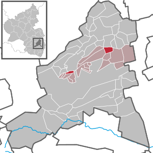
Freinsheim (German: [ˈfʁaɪnshaɪm]; Palatine German: Fränsem) is a town in the Bad Dürkheim district in Rhineland-Palatinate, Germany. With about 5,000 inhabitants, it is among the state's smaller towns. It is also the seat of the like-named Verbandsgemeinde, a kind of collective municipality.

Dackenheim
Municipality in Rhineland-Palatinate, Germany
Distance: Approx. 2612 meters
Latitude and longitude: 49.52166667,8.18472222
Dackenheim is an Ortsgemeinde – a municipality belonging to a Verbandsgemeinde, a kind of collective municipality – in the Bad Dürkheim district in Rhineland-Palatinate, Germany.

Erpolzheim
Municipality in Rhineland-Palatinate, Germany
Distance: Approx. 2120 meters
Latitude and longitude: 49.48916667,8.22444444
Erpolzheim is an Ortsgemeinde – a municipality belonging to a Verbandsgemeinde, a kind of collective municipality – in the Bad Dürkheim district in Rhineland-Palatinate, Germany.
Herxheim am Berg
Municipality in Rhineland-Palatinate, Germany
Distance: Approx. 2387 meters
Latitude and longitude: 49.51,8.17972222
Herxheim am Berg is an Ortsgemeinde – a municipality belonging to a Verbandsgemeinde, a kind of collective municipality – in the Bad Dürkheim district in Rhineland-Palatinate, Germany.
Kallstadt
Municipality in Rhineland-Palatinate, Germany
Distance: Approx. 3178 meters
Latitude and longitude: 49.49055556,8.17583333
Kallstadt (German pronunciation: [ˈkalʃtat]) is a village in the Palatine part of Rhineland-Palatinate, one of Germany's 16 federal states. It is part of the Rhine-Neckar Metropolitan Region whose largest city is Mannheim, Germany's 22nd largest city. During much of the 19th century, it was part of the Kingdom of Bavaria.

Weisenheim am Sand
Municipality in Rhineland-Palatinate, Germany
Distance: Approx. 2869 meters
Latitude and longitude: 49.51805556,8.24777778
Weisenheim am Sand (Palatine German: Weisrem) is an Ortsgemeinde – a municipality belonging to a Verbandsgemeinde, a kind of collective municipality – in the Bad Dürkheim district in Rhineland-Palatinate, Germany.

Freinsheim (Verbandsgemeinde)
Distance: Approx. 316 meters
Latitude and longitude: 49.507,8.208
Freinsheim is a Verbandsgemeinde ("collective municipality") in the district of Bad Dürkheim, Rhineland-Palatinate, Germany. The seat of the Verbandsgemeinde is in Freinsheim.
Freinsheim station
Railway station in Freinsheim, Germany
Distance: Approx. 706 meters
Latitude and longitude: 49.5025,8.20472222
Freinsheim station is a station in Freinsheim in the German state of Rhineland-Palatinate. It is at the junction of the Palatinate Northern Railway and the Freinsheim–Frankenthal railway. The station is one of the most important railway junctions in the Palatinate.

Historic Toy Museum, Freinsheim
Distance: Approx. 117 meters
Latitude and longitude: 49.50546389,8.21259139
The Historic Toy Museum in Freinsheim (Historisches Spielzeugmuseum Freinsheim) in Germany is a private collection of old toys.
Erpolzheim station
Railway station in Erpolzheim, Germany
Distance: Approx. 2018 meters
Latitude and longitude: 49.4884,8.2108
Erpolzheim station is a railway station in the municipality of Erpolzheim, located in the district of Bad Dürkheim in Rhineland-Palatinate, Germany.

St. Jacob's Church, Herxheim am Berg
Protestant church in Herxheim am Berg
Distance: Approx. 2219 meters
Latitude and longitude: 49.50974,8.18201
St. Jacob's Church (St.-Jakob-Kirche) is a Protestant parish church in Herxheim am Berg, Rhineland-Palatinate. The church and its cemetery are protected by the General Directorate for Cultural Heritage Rhineland-Palatinate.
Weather in this IP's area
few clouds
2 Celsius
2 Celsius
1 Celsius
5 Celsius
1036 hPa
83 %
1036 hPa
1021 hPa
10000 meters
1.33 m/s
1.36 m/s
39 degree
11 %


