84.200.76.161 - IP Lookup: Free IP Address Lookup, Postal Code Lookup, IP Location Lookup, IP ASN, Public IP
Country:
Region:
City:
Location:
Time Zone:
Postal Code:
ISP:
ASN:
language:
User-Agent:
Proxy IP:
Blacklist:
IP information under different IP Channel
ip-api
Country
Region
City
ASN
Time Zone
ISP
Blacklist
Proxy
Latitude
Longitude
Postal
Route
db-ip
Country
Region
City
ASN
Time Zone
ISP
Blacklist
Proxy
Latitude
Longitude
Postal
Route
IPinfo
Country
Region
City
ASN
Time Zone
ISP
Blacklist
Proxy
Latitude
Longitude
Postal
Route
IP2Location
84.200.76.161Country
Region
nordrhein-westfalen
City
eschweiler
Time Zone
Europe/Berlin
ISP
Language
User-Agent
Latitude
Longitude
Postal
ipdata
Country
Region
City
ASN
Time Zone
ISP
Blacklist
Proxy
Latitude
Longitude
Postal
Route
Popular places and events near this IP address

Bad Münstereifel
Place in North Rhine-Westphalia, Germany
Distance: Approx. 2778 meters
Latitude and longitude: 50.55305556,6.76611111
Bad Münstereifel (German pronunciation: [ˈbaːt mʏnstɐˈʔaɪ̯fl̩] ) is a historical spa town in the district of Euskirchen, Germany, with about 17,000 inhabitants, situated in the far southwest of the German state of North Rhine-Westphalia. The little town is one of only a few historical towns in the southwest of North Rhine-Westphalia, and because of this is often overcrowded by tourists throughout spring and summer.

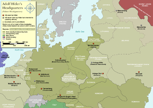
Felsennest
Führer headquarters
Distance: Approx. 3565 meters
Latitude and longitude: 50.54583333,6.76944444
The Felsennest ("Rocky Eyrie" in English) was the codename for one of several Führer Headquarters used by Adolf Hitler during the course of World War II. It was located near Bad Münstereifel, in the western part of Germany. It was much more cramped than Hitler's other headquarters, having only four rooms. Hitler was at the Felsennest in the autumn of 1939, because there were plans to invade France and the Low Countries.
Lessenich (Mechernich)
Village of Mechernich in North Rhine-Westphalia, Germany
Distance: Approx. 4234 meters
Latitude and longitude: 50.60833333,6.72166667
Lessenich is a small village at the northern rim of the Eifel hill chain. It belongs to the town of Mechernich in the district of Euskirchen. Lessenich is situated in the centre of the triangle of Mechernich, Euskirchen und Bad Münstereifel.

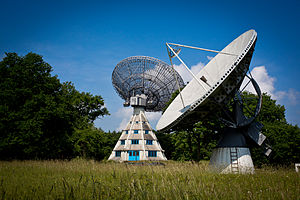
Stockert Radio Telescope
Observatory
Distance: Approx. 1298 meters
Latitude and longitude: 50.57,6.72333333
The Stockert Radio Telescope is a historical radio telescope in the Eifel mountain range in Germany, situated 12 km from the Effelsberg 100-m Radio Telescope.

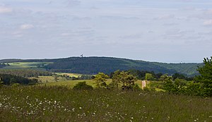
Stockert (hill)
Distance: Approx. 1424 meters
Latitude and longitude: 50.56938889,6.72172222
The Stockert is a 435-metre-high hill which rises between Eschweiler and Holzheim in the district of Euskirchen in the borough of Bad Münstereifel, in the Eifel mountains of Germany, and west of the city of Bonn.

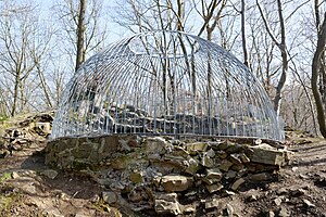
Alte Burg (Bad Münstereifel)
Castle in Germany
Distance: Approx. 2525 meters
Latitude and longitude: 50.558475,6.769482
The Alte Burg (also Alte Burg im Quecken or Alte Burg "am Quecken") in Bad Münstereifel, Germany, is a circular rampart that is the remains of a fortification from the Carolingian period. The refuge castle acted as a place of retreat for the local population and as protection for the daughter monastery of Prüm Abbey. The defences dating to the 9th century have been designated as a protected monument.

Herkelstein
Hill in Mechernich, North Rhine-Westphalia, Germany
Distance: Approx. 2621 meters
Latitude and longitude: 50.57333,6.70425
The Herkelstein is a hill located in the town of Mechernich, North Rhine-Westphalia, Germany. Its highest point is 1,426ft above sea level.

Arloff Castle
Distance: Approx. 3937 meters
Latitude and longitude: 50.592494,6.787135
Arloff Castle (German: Burg Arloff) is on the river Erft in the village of Arloff, part of the borough of Bad Münstereifel in the county of Euskirchen, in the German state of North Rhine-Westphalia. The buildings of the former water castle of Arloff, which today look somewhat ordinary by the River Erft, belong to the typologically important castles of the Rhineland, because such a well preserved example of a purpose-built fortification from the Early Gothic period is rare. It was originally surrounded by moats which were fed by the Erft.
Arloff
Stadtteil of Bad Münstereifel in North Rhine-Westphalia, Germany
Distance: Approx. 4316 meters
Latitude and longitude: 50.594414,6.791567
Arloff is a village in the borough of Bad Münstereifel in the district of Euskirchen in the German state of North Rhine-Westphalia. Arloff Castle is a well preserved fortified building from the early Gothic period.
Bad Münstereifel station
Railway station in Bad Münstereifel, Germany
Distance: Approx. 2220 meters
Latitude and longitude: 50.55888889,6.76438889
Bad Münstereifel station is a railway station in the municipality of Bad Münstereifel, located in the Euskirchen district in North Rhine-Westphalia, Germany.

Bad Münstereifel-Iversheim station
Railway station in Bad Münstereifel, Germany
Distance: Approx. 2293 meters
Latitude and longitude: 50.5829,6.7692
Bad Münstereifel-Iversheim station is a railway station in the Iversheim district of the municipality of Bad Münstereifel, located in the Euskirchen district in North Rhine-Westphalia, Germany.

Bad Münstereifel-Arloff station
Railway station in Bad Münstereifel, Germany
Distance: Approx. 4275 meters
Latitude and longitude: 50.5977,6.7868
Bad Münstereifel-Arloff station is a railway station in the Arloff district of the municipality of Bad Münstereifel, located in the Euskirchen district in North Rhine-Westphalia, Germany.
Weather in this IP's area
overcast clouds
6 Celsius
6 Celsius
6 Celsius
7 Celsius
996 hPa
77 %
996 hPa
955 hPa
10000 meters
1.34 m/s
4.47 m/s
157 degree
96 %


