84.19.101.23 - IP Lookup: Free IP Address Lookup, Postal Code Lookup, IP Location Lookup, IP ASN, Public IP
Country:
Region:
City:
Location:
Time Zone:
Postal Code:
ISP:
ASN:
language:
User-Agent:
Proxy IP:
Blacklist:
IP information under different IP Channel
ip-api
Country
Region
City
ASN
Time Zone
ISP
Blacklist
Proxy
Latitude
Longitude
Postal
Route
db-ip
Country
Region
City
ASN
Time Zone
ISP
Blacklist
Proxy
Latitude
Longitude
Postal
Route
IPinfo
Country
Region
City
ASN
Time Zone
ISP
Blacklist
Proxy
Latitude
Longitude
Postal
Route
IP2Location
84.19.101.23Country
Region
england
City
kendal
Time Zone
Europe/London
ISP
Language
User-Agent
Latitude
Longitude
Postal
ipdata
Country
Region
City
ASN
Time Zone
ISP
Blacklist
Proxy
Latitude
Longitude
Postal
Route
Popular places and events near this IP address

Quaker Tapestry
Embroidery depicting the history of Quakerism
Distance: Approx. 355 meters
Latitude and longitude: 54.32849,-2.74297
The Quaker Tapestry consists of 77 panels illustrating the history of Quakerism from the 17th century to the present day. The idea of Quaker Anne Wynn-Wilson, the tapestry has a permanent home at the Friends Meeting House at Kendal, Cumbria, England. The design was heavily influenced by the Bayeux Tapestry, and includes similar design choices, including three horizontal divisions within panels, embroidered outlines for faces and hands, and solid infilling of clothing, which is embroidered in the Bayeux technique.

Kendal
Town in Cumbria, England
Distance: Approx. 191 meters
Latitude and longitude: 54.326,-2.745
Kendal, once Kirkby in Kendal or Kirkby Kendal, is a market town and civil parish in the unitary authority of Westmorland and Furness, England. It lies within the River Kent's dale, from which its name is derived, just outside the boundary of the Lake District National Park. In the Domesday Book of 1086, the area was collected under Yorkshire.

Barony of Kendal
Subdivision of the English historic county of Westmorland
Distance: Approx. 34 meters
Latitude and longitude: 54.327,-2.748
The Barony of Kendal is a subdivision of the English historic county of Westmorland. It evolved from one of two ancient baronies that make up the county, the other being the Barony of Westmorland (also known as North Westmorland, or the Barony of Appleby). In 1974, the entire county became part of the modern county of Cumbria and ceased to have an administrative function.

Abbot Hall Art Gallery
Grade I listed art museum in Kendal, United Kingdom
Distance: Approx. 481 meters
Latitude and longitude: 54.32305556,-2.74388889
Abbot Hall Art Gallery is an art gallery in Kendal, England. Abbot Hall was built in 1759 by Colonel George Wilson, the second son of Daniel Wilson of Dallam Tower, a large house and country estate nearby. It was built on the site of the old Abbot's Hall, roughly where the museum is today.

Kendal Parish Church
Church in England, England
Distance: Approx. 517 meters
Latitude and longitude: 54.3225,-2.7446
Kendal Parish Church, also known as the Holy Trinity Church due to its dedication to the Holy Trinity, is the Anglican parish church of Kendal, Cumbria, England. It is recorded in the National Heritage List for England as a designated Grade I listed building. Visitors to the church are struck by its size and the lightness of the interior.

Museum of Lakeland Life & Industry
Distance: Approx. 456 meters
Latitude and longitude: 54.32303,-2.74485
The Museum of Lakeland Life & Industry, formerly the Museum of Lakeland Life and sometimes abbreviated to MOLLI, is a local museum in Kendal, Cumbria, northwest England. The museum was opened in 1971 by Princess Alexandra. It won the first ever UK Museum of the Year award in 1973.

Castle Howe
Castle in Cumbria, England
Distance: Approx. 423 meters
Latitude and longitude: 54.3239,-2.7518
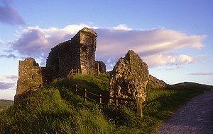
Castle Howe is a motte and bailey castle in the town of Kendal, England.

Church of Holy Trinity and St George, Kendal
Church in Cumbria, England
Distance: Approx. 298 meters
Latitude and longitude: 54.328,-2.7435
The Church of Holy Trinity and St George is in New Road, Kendal, Cumbria, England. It is an active Roman Catholic parish church in the diocese of Lancaster. It is recorded in the National Heritage List for England as a designated Grade II* listed building.

Queen Katherine Street drill hall, Kendal
Distance: Approx. 377 meters
Latitude and longitude: 54.32475,-2.74297
The Queen Katherine Street drill hall is a former military installation located on Queen Katherine Street, off Aynam Road, in Kendal, Cumbria, England.

Kendal Town Hall
Municipal building in Kendal, Cumbria, England
Distance: Approx. 34 meters
Latitude and longitude: 54.3269,-2.7471
The Town Hall is a municipal building in Highgate, Kendal, Cumbria. It is a Grade II listed building. It serves as the headquarters of Kendal Town Council and also forms part of the complex of buildings which serves as the headquarters of Westmorland and Furness Council.

Westmorland and Furness
District in Cumbria, England
Distance: Approx. 191 meters
Latitude and longitude: 54.326,-2.745
Westmorland and Furness is a unitary authority area in Cumbria, England. The economy is mainly focused on tourism around both the Lake District and Cumbria Coast, shipbuilding and the port in Barrow-in-Furness, and agriculture in the rural parts of the area. The council area formed on 1 April 2023, on the abolition of Cumbria County Council The council covers the areas formerly served by the districts of Barrow-in-Furness, Eden, and South Lakeland, which also ceased to function.

Friends Meeting House, Kendal
Distance: Approx. 355 meters
Latitude and longitude: 54.32849,-2.74297
Kendal Friends Meeting House is a Friends meeting house of the Religious Society of Friends (Quakers) in Kendal, Cumbria, in north-western England. There have been Quakers in Kendal since the 17th century when the town was visited by George Fox. The present meeting house was purpose-built in 1816 to replace the previous building used by local Quakers.
Weather in this IP's area
broken clouds
5 Celsius
4 Celsius
5 Celsius
7 Celsius
992 hPa
89 %
992 hPa
973 hPa
10000 meters
1.73 m/s
2.37 m/s
267 degree
82 %