83.69.10.250 - IP Lookup: Free IP Address Lookup, Postal Code Lookup, IP Location Lookup, IP ASN, Public IP
Country:
Region:
City:
Location:
Time Zone:
Postal Code:
ISP:
ASN:
language:
User-Agent:
Proxy IP:
Blacklist:
IP information under different IP Channel
ip-api
Country
Region
City
ASN
Time Zone
ISP
Blacklist
Proxy
Latitude
Longitude
Postal
Route
db-ip
Country
Region
City
ASN
Time Zone
ISP
Blacklist
Proxy
Latitude
Longitude
Postal
Route
IPinfo
Country
Region
City
ASN
Time Zone
ISP
Blacklist
Proxy
Latitude
Longitude
Postal
Route
IP2Location
83.69.10.250Country
Region
arkhangel'skaya oblast'
City
arkhangel'sk
Time Zone
Europe/Moscow
ISP
Language
User-Agent
Latitude
Longitude
Postal
ipdata
Country
Region
City
ASN
Time Zone
ISP
Blacklist
Proxy
Latitude
Longitude
Postal
Route
Popular places and events near this IP address

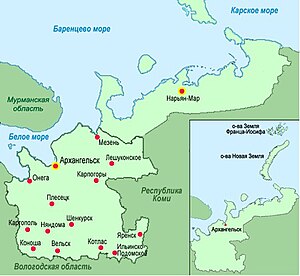
Arkhangelsk
City in Arkhangelsk Oblast, Russia
Distance: Approx. 430 meters
Latitude and longitude: 64.54305556,40.5375
Arkhangelsk (Russian: Архангельск, pronounced [ɐrˈxanɡʲɪlʲsk]) is a city and the administrative center of Arkhangelsk Oblast, Russia. It lies on both banks of the Northern Dvina near its mouth into the White Sea. The city spreads for over 40 kilometres (25 mi) along the banks of the river and numerous islands of its delta.
2004 Arkhangelsk explosion
Gas explosion in Russia caused by sabotage
Distance: Approx. 1140 meters
Latitude and longitude: 64.537,40.566
On March 16, 2004, an explosion destroyed a corner section of a nine-storey Soviet-era apartment building in Arkhangelsk, Russia. It happened at 3:03 a.m. local time (UTC +3).
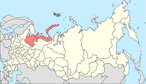
Northern Oblast (1936–1937)
1936–1937 unit of Russia
Distance: Approx. 892 meters
Latitude and longitude: 64.53333333,40.53333333
Northern Oblast (Russian: Северная область, romanized: Severnaya oblast) was an administrative-territorial unit (oblast) of the Russian SFSR from 1936 to 1937. Its seat was in the city of Arkhangelsk. The oblast was located in the north of European Russia and its territory is currently divided between Arkhangelsk, Vologda, Kostroma and Kirov oblasts and the Nenets Autonomous Okrug.
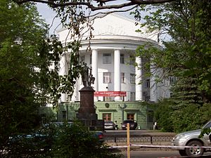
Arkhangelsk State Technical University
Building
Distance: Approx. 1279 meters
Latitude and longitude: 64.52888889,40.54916667
Arkhangelsk State Technical University is a university founded in 1994. The university was created on the basis of the Arkhangelsk Forestry Engineering Institute. This university is composed of at least eight faculties and four institutes.

Arkhangelsk Gostiny Dvor
Network of fortified depots in Arkhangelsk
Distance: Approx. 1544 meters
Latitude and longitude: 64.53916667,40.51111111
The Merchant Court (Гостиный двор) is a network of fortified depots built on the Pur-Navolok promontory in Arkhangelsk by a team of German and Dutch masons between 1668 and 1684. Only the northern tower of the original structure and parts of the western wall facing the Northern Dvina still stand. In the 17th century Arkhangelsk handled more than half of the country's exports.
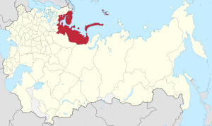
Arkhangelsk Governorate
1796–1929 unit of Russia
Distance: Approx. 892 meters
Latitude and longitude: 64.53333333,40.53333333
Arkhangelsk Governorate (Russian: Архангельская губерния, romanized: Arkhangel'skaya guberniya) was an administrative-territorial unit (guberniya) of the Russian Empire and the Russian SFSR, which existed from 1796 until 1929. Its seat was in Arkhangelsk. The governorate was located in the north of the Russian Empire and bordered Tobolsk Governorate in the east, Vologda Governorate in the south, Olonets Governorate in the southwest, Sweden (later Grand Duchy of Finland and later independent Finland) in the west, and Norway in north-west.
Arkhangelsk Regional Rescue Service
Distance: Approx. 2018 meters
Latitude and longitude: 64.5275,40.57361111
The Arkhangelsk Regional Rescue Service (ARRS) was founded by the governor of Arkhangelsk Oblast, Russia on 6 April 1998 to provide emergency assistance and preparedness in dealing with a variety of emergency situations. It operates under the jurisdiction of the Agency for Fire Protection and Civil Defence of Arkhangelsk Oblast and is a component in the Russian system of search and rescue. The head of the ARRS in 1998-2013 was Igor Polivany.
Northern Krai
Administrative unit of Russia (1929–1936)
Distance: Approx. 892 meters
Latitude and longitude: 64.53333333,40.53333333
Northern Krai (Russian: Северный край, romanized: Severny Krai) was an administrative-territorial unit (krai) of the Russian SFSR from 1929 to 1936. Its seat was in the city of Arkhangelsk. The krai was located in the north of European Russia, and its territory is currently divided between Arkhangelsk, Vologda, Kostroma, and Kirov Oblasts, the Nenets Autonomous Okrug, and the Komi Republic.
Northern (Arctic) Federal University
Russian university
Distance: Approx. 1278 meters
Latitude and longitude: 64.5289,40.5492
Northern (Arctic) Federal University named after M.V. Lomonosov (Russian: Северный (Арктический) Федеральный университет имени М. В. Ломоносова), or NArFU for short, is a Federal University established in Arkhangelsk pursuant to Russian Federation President Dmitry Medvedev’s Decree dd. 8 June 2010 on the basis of Arkhangelsk State Technical University (ASTU).
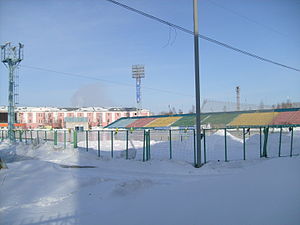
Trud Stadium (Arkhangelsk)
Sports venue in Arkhangelsk, Russia
Distance: Approx. 1986 meters
Latitude and longitude: 64.5571,40.5307
Trud Stadium is a sports venue in Arkhangelsk. It is the home stadium of bandy club Vodnik and has hosted the Bandy World Championship twice. The venue is used mostly for bandy and association football.
Archangel Allied Cemetery
CWGC cemetery in Russia
Distance: Approx. 1436 meters
Latitude and longitude: 64.553,40.5429
The Archangel Allied Cemetery is a military cemetery in Archangel, Russia, that is under the management of the Commonwealth War Graves Commission. Amongst the buried is Charles Gordon-Lennox, Lord Settrington, Samuel George Pearse, an Australian soldier who received the Victoria Cross during the 1919 North Russia intervention in the Russian Civil War and Canadian Royce Coleman Dyer.

Arkhangelsk FSB office bombing
2018 terrorist attack against the Russian security service
Distance: Approx. 1205 meters
Latitude and longitude: 64.5359,40.5201
The Arkhangelsk FSB office bombing was a suicide bombing that occurred in Arkhangelsk, Russia. On the morning of 31 October 2018, Mikhail Vasilievich Zhlobitsky, a 17-year old tekhnikum student entered the local office of the Russian Federal Security Service (FSB) and pulled a manually controlled Improvised explosive device from under his clothes and detonated it. He died on the spot and the explosion injured three local FSB officers.
Weather in this IP's area
overcast clouds
-10 Celsius
-12 Celsius
-10 Celsius
-10 Celsius
999 hPa
97 %
999 hPa
997 hPa
7501 meters
1.36 m/s
2.35 m/s
21 degree
100 %
