Country:
 Poland
Region:
City:
Latitude and Longitude:
Time Zone:
Postal Code:
IP information under different IP Channel
ip-api
Country
Region
City
ASN
Time Zone
ISP
Blacklist
Proxy
Latitude
Longitude
Postal
Route
IPinfo
Country
Region
City
ASN
Time Zone
ISP
Blacklist
Proxy
Latitude
Longitude
Postal
Route
MaxMind
Country
Region
City
ASN
Time Zone
ISP
Blacklist
Proxy
Latitude
Longitude
Postal
Route
Luminati
Country
PLRegion
24
City
katowice
ASN
Time Zone
Europe/Warsaw
ISP
Silesian University of Technology, Computer Centre
Latitude
Longitude
Postal
db-ip
Country
Region
City
ASN
Time Zone
ISP
Blacklist
Proxy
Latitude
Longitude
Postal
Route
ipdata
Country
Region
City
ASN
Time Zone
ISP
Blacklist
Proxy
Latitude
Longitude
Postal
Route
Popular places and events near this IP address

Gliwice
City in Silesian Voivodeship, Poland
Distance: Approx. 5422 meters
Latitude and longitude: 50.28333333,18.66666667
Gliwice (Polish: [ɡliˈvit͡sɛ] ;Silesian: Gliwicy) is a city in Upper Silesia, in southern Poland. The city is located in the Silesian Highlands, on the Kłodnica river (a tributary of the Oder). It lies approximately 25 km west from Katowice, the regional capital of the Silesian Voivodeship.

Czerwionka-Leszczyny
Place in Silesian Voivodeship, Poland
Distance: Approx. 5909 meters
Latitude and longitude: 50.18333333,18.68333333
Czerwionka-Leszczyny [t͡ʂɛrˈvʲɔŋka lɛʂˈt͡ʂɨnɨ] (German: Czerwionka-Leschczin) is a town in Silesian Voivodeship in southern Poland. It is the only town in Rybnik county (which is separate from Rybnik city) and the seat of the larger Czerwionka-Leszczyny municipality which also includes 6 villages. Czerwionka-Leszczyny was created by a merger of two towns (Czerwionka and Leszczyny) and two villages (Czuchów and Dębieńsko), which to this day maintain their separate identities.

Knurów
Place in Silesian Voivodeship, Poland
Distance: Approx. 2500 meters
Latitude and longitude: 50.21666667,18.68333333
Knurów ([ˈknuruf] ; German: Knurow; Silesian: Knurōw) is a city near Katowice in Silesia, southern Poland. Knurów is an outer city of the Metropolis GZM, a metropolis with a population of two million. Knurów is located in the Silesian Highlands, on the Bierawka River, a tributary of the Oder River.

Gliwice County
County in Silesian Voivodeship, Poland
Distance: Approx. 5422 meters
Latitude and longitude: 50.28333333,18.66666667
Gliwice County (Polish: powiat gliwicki) is a unit of territorial administration and local government (powiat) in Silesian Voivodeship, southern Poland. It came into being on January 1, 1999, as a result of the Polish local government reforms passed in 1998. Its administrative seat is the city of Gliwice, although the city is not part of the county (it constitutes a separate city county).
Gierałtowice, Silesian Voivodeship
Village in Silesian Voivodeship, Poland
Distance: Approx. 4355 meters
Latitude and longitude: 50.21666667,18.71666667
Gierałtowice [ɡʲɛrau̯tɔˈvit͡sɛ] is a village in Gliwice County, Silesian Voivodeship, in southern Poland. It is the seat of the gmina (administrative district) called Gmina Gierałtowice. It lies approximately 9 kilometres (6 mi) south-east of Gliwice and 21 km (13 mi) west of the regional capital Katowice.
Gmina Gierałtowice
Gmina in Silesian Voivodeship, Poland
Distance: Approx. 4355 meters
Latitude and longitude: 50.21666667,18.71666667
Gmina Gierałtowice is a rural gmina (administrative district) in Gliwice County, Silesian Voivodeship, in southern Poland. Its seat is the village of Gierałtowice, which lies approximately 9 kilometres (6 mi) south-east of Gliwice and 21 km (13 mi) west of the regional capital Katowice. The gmina covers an area of 39 square kilometres (15.1 sq mi), and as of 2019 its total population is 12,096.

Roman Catholic Diocese of Gliwice
Roman Catholic diocese in Poland
Distance: Approx. 6305 meters
Latitude and longitude: 50.2913,18.6655
The Diocese of Gliwice (Latin: Glivicen(sis)) is a Latin Church ecclesiastical territory or diocese of the Catholic Church in Poland. Its episcopal see is located in the city of Gliwice. The Diocese of Gliwice is a suffragan diocese in the ecclesiastical province of the Archdiocese of Katowice.
Kuźnia Nieborowska
Village in Silesian Voivodeship, Poland
Distance: Approx. 5889 meters
Latitude and longitude: 50.2,18.6
Kuźnia Nieborowska [ˈkuʑɲa ɲɛbɔˈrɔfska] is a village in the administrative district of Gmina Pilchowice, within Gliwice County, Silesian Voivodeship, in southern Poland. It lies approximately 11 kilometres (7 mi) south-west of Gliwice and 30 km (19 mi) west of the regional capital Katowice.

Nieborowice
Village in Silesian Voivodeship, Poland
Distance: Approx. 4876 meters
Latitude and longitude: 50.21666667,18.6
Nieborowice [ɲɛbɔrɔˈvit͡sɛ] is a village in the administrative district of Gmina Pilchowice, within Gliwice County, Silesian Voivodeship, in southern Poland. It lies approximately 9 kilometres (6 mi) south-west of Gliwice and 29 km (18 mi) west of the regional capital Katowice. The oldest known mention of the village dates back to 1407.

Żernica
Village in Silesian Voivodeship, Poland
Distance: Approx. 4446 meters
Latitude and longitude: 50.23333333,18.6
Żernica [ʐɛrˈnit͡sa] is a village in the administrative district of Gmina Pilchowice, within Gliwice County, Silesian Voivodeship, in southern Poland. It lies approximately 8 kilometres (5 mi) south-west of Gliwice and 29 km (18 mi) west of the regional capital Katowice.
Szczygłowice Coal Mine
Mine in Knurów, Poland
Distance: Approx. 5462 meters
Latitude and longitude: 50.18944444,18.63277778
The Szczygłowice coal mine is a large mine in the south of Poland in Knurów, Silesian Voivodeship, 304 km south-west of the capital, Warsaw. Szczygłowice represents one of the largest coal reserve in Poland having estimated reserves of 300 million tonnes of coal. The annual coal production is around 3.8 million tonnes.
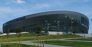
Gliwice Arena
Multi-purpose indoor arena in Gliwice, Poland
Distance: Approx. 5923 meters
Latitude and longitude: 50.28572222,18.68602778
Gliwice Arena, known for sponsorship reasons as PreZero Arena Gliwice, is a multi-purpose indoor arena in Gliwice, Poland. The arena has 13,752 seats in its four stands and provides room for up to 17,178 spectators in the main arena, standing spaces included, making it one of the largest entertainment and sports halls in the country.
Weather in this IP's area
few clouds
13 Celsius
13 Celsius
12 Celsius
14 Celsius
1024 hPa
76 %
1024 hPa
994 hPa
10000 meters
4.86 m/s
12.55 m/s
82 degree
15 %
06:29:00
18:48:30