Country:
Region:
City:
Latitude and Longitude:
Time Zone:
Postal Code:
IP information under different IP Channel
ip-api
Country
Region
City
ASN
Time Zone
ISP
Blacklist
Proxy
Latitude
Longitude
Postal
Route
Luminati
Country
Region
z
City
nazareth
ASN
Time Zone
Asia/Jerusalem
ISP
United Fiber to the home LTD
Latitude
Longitude
Postal
IPinfo
Country
Region
City
ASN
Time Zone
ISP
Blacklist
Proxy
Latitude
Longitude
Postal
Route
db-ip
Country
Region
City
ASN
Time Zone
ISP
Blacklist
Proxy
Latitude
Longitude
Postal
Route
ipdata
Country
Region
City
ASN
Time Zone
ISP
Blacklist
Proxy
Latitude
Longitude
Postal
Route
Popular places and events near this IP address

Basilica of the Annunciation
Catholic church in Nazareth
Distance: Approx. 462 meters
Latitude and longitude: 32.70222222,35.29777778
The Church of the Annunciation (Latin: Basilica Annuntiationis, Arabic: كنيسة البشارة, Hebrew: כנסיית הבשורה), sometimes also referred to as the Basilica of the Annunciation, is a Catholic church in Nazareth, in northern Israel. It is one of two claimants to the site of the Annunciation – in which angel Gabriel appeared to the Virgin Mary and announced that she would give birth to Jesus – the other being the Greek Orthodox Church of the Annunciation. It was established over what Catholic tradition holds to be the site of the house of the Virgin Mary.

White Mosque, Nazareth
Ottoman-era mosque in Israel
Distance: Approx. 549 meters
Latitude and longitude: 32.703425,35.29823611
The White Mosque (Arabic: المسجد الأبيض, al-Masjid al-Abyad; Hebrew: המסגד הלבן, HaMisgad HaLavan) is an Ottoman-era mosque in Nazareth, Israel, occupied Palestine. It is located in Harat Alghama or the "Mosque Quarter" in the centre of Nazareth's Old Market. The mosque's pencil-shaped minaret, cream-coloured walls, and green-coloured trim and dome are an example of the Ottoman architecture that is commonly found throughout the city.

Mensa Christi Church
Catholic church in Nazareth, Israel
Distance: Approx. 407 meters
Latitude and longitude: 32.70434722,35.29521111
Mensa Christi is a Roman Catholic church located in Nazareth, northern Israel.

Christ Church, Nazareth
Distance: Approx. 307 meters
Latitude and longitude: 32.70236111,35.29597222
Christ Church (Hebrew: כנסיית המשיח, romanized: Knesset HaMashiakh, lit. 'Assembly of the Mashiakh'; Arabic: كنيسة المسيح, romanized: Kanisah al-Masîḥ) is an Anglican church located in the town of Nazareth, Israel. Due to financial troubles the church couldn't be completed by 1871 and lacked its intended spire, until one was finally added 143 years later, in 2014. Nearby lies the famous Basilica of the Annunciation.

Nazareth Village
Open-air museum in Nazareth, Israel
Distance: Approx. 180 meters
Latitude and longitude: 32.70008056,35.29161667
Nazareth Village is an open-air museum in Nazareth, Israel, that reconstructs and reenacts village life in the Galilee in the time of Jesus.
St. Joseph's Church, Nazareth
Distance: Approx. 541 meters
Latitude and longitude: 32.70305556,35.29833333
St. Joseph's Church is a Franciscan Roman Catholic church in the Old City of Nazareth, modern-day Northern Israel. It was built in 1914 over the remains of much older churches.

Synagogue Church (Nazareth)
Distance: Approx. 418 meters
Latitude and longitude: 32.70333333,35.29666667
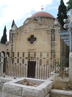
The Synagogue Church is a small Christian church in the heart of Nazareth known by this name due to a tradition claiming that it the location where the village synagogue stood in Jesus' time. Above its doorway is an embedded sign in Arabic and English: "Synagogue". The structure is administered by the Melkite Greek Catholic Church.
Fauzi Azar Inn
Distance: Approx. 439 meters
Latitude and longitude: 32.70460833,35.29534722
Fauzi Azar by Abraham Hostels (formerly known as Fauzi Azar Inn) is a guesthouse located in the old city of Nazareth, Israel. It is on the Jesus Trail. In recent years, the Fauzi Azar has played a role in working with the Christian Arab community of Nazareth through various projects.

EMMS Nazareth Hospital
Hospital in Northern District, Israel
Distance: Approx. 134 meters
Latitude and longitude: 32.7017,35.2917
The EMMS Nazareth Hospital, also known as Scottish Hospital and English Hospital, is the Christian community hospital in Nazareth, Israel. It was founded as a Christian mission by Dr. Kaloost Vartan and the Edinburgh Medical Missionary Society in 1861.
Greek Catholic Church of Nazareth
Church in Nazareth, Israel
Distance: Approx. 458 meters
Latitude and longitude: 32.7033,35.2972
The Greek Catholic Church of the Annunciation is the parish church of the Melkite Greek Catholic community in the city of Nazareth in northern Israel.

Basilica of Jesus the Adolescent
Church in Nazareth, Israel
Distance: Approx. 654 meters
Latitude and longitude: 32.7069,35.2947
The Basilica of Jesus the Adolescent, also known as the Salesian church (Arabic: كنيسة السالزيان; Hebrew: כנסייה הסלזיאנית) is a Catholic church in Nazareth in Israel, belonging to the Salesians of Don Bosco. The church is located next to the school of the Salesians. In Gothic style, was built between 1906 and 1923 on a hill called "Mount of the Start" which overlooks the city, where, according to tradition, Jesus spent his youth.

Monastery Saint Claire (Nazareth)
Distance: Approx. 619 meters
Latitude and longitude: 32.69583333,35.29472222
The Monastery Saint Claire (French: Monastère Sainte-Claire; Hebrew: נזירות סנט קליר, Nazirot Sanat Qlīr; Arabic: راهبات القدیصة کلارا, Rāhibāt al-Qudīṣah Klārā), also known as the Convent of Mary's Fear and by other names, is a convent of the Poor Clares on Tremor Hill in southern Nazareth, Israel. Established in 1884, it is primarily known for the productive time the now-sainted Charles de Foucauld spent there at the end of the 19th century. Expelled from the Ottoman Empire at the onset of World War I, the nuns of the abbey relocated to Malta, founding a new community there.
Weather in this IP's area
light rain
14 Celsius
14 Celsius
14 Celsius
14 Celsius
1014 hPa
88 %
1014 hPa
971 hPa
10000 meters
1.42 m/s
1.83 m/s
212 degree
16 %
06:11:53
16:36:30

