83.138.247.95 - IP Lookup: Free IP Address Lookup, Postal Code Lookup, IP Location Lookup, IP ASN, Public IP
Country:
 Spain
SpainRegion:
City:
Location:
Time Zone:
Postal Code:
ISP:
ASN:
language:
User-Agent:
Proxy IP:
Blacklist:
IP information under different IP Channel
ip-api
Country
Region
City
ASN
Time Zone
ISP
Blacklist
Proxy
Latitude
Longitude
Postal
Route
db-ip
Country
Region
City
ASN
Time Zone
ISP
Blacklist
Proxy
Latitude
Longitude
Postal
Route
IPinfo
Country
Region
City
ASN
Time Zone
ISP
Blacklist
Proxy
Latitude
Longitude
Postal
Route
IP2Location
83.138.247.95Country
esRegion
andalucia
City
garrucha
Time Zone
Europe/Madrid
ISP
Language
User-Agent
Latitude
Longitude
Postal
ipdata
Country
Region
City
ASN
Time Zone
ISP
Blacklist
Proxy
Latitude
Longitude
Postal
Route
Popular places and events near this IP address
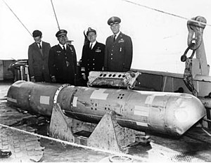
1966 Palomares incident
Collision between a USAF B-52G and KC-135 over the Mediterranean Sea near Spain
Distance: Approx. 7877 meters
Latitude and longitude: 37.24916667,-1.79694444
The Palomares incident occurred on 17 January 1966, when a B-52G bomber of the United States Air Force's Strategic Air Command collided with a KC-135 tanker during mid-air refueling at 31,000 feet (9,450 m) over the Mediterranean Sea, off the coast of Spain. The KC-135 was destroyed when its fuel load ignited, killing all four crew members. The B-52G broke apart, killing three of the seven crew members aboard.

Mojácar
Municipality in Andalusia, Spain
Distance: Approx. 5246 meters
Latitude and longitude: 37.14027778,-1.85138889
Mojácar (Spanish pronunciation: [moˈxakaɾ]) is a municipality situated in the southeast of the Province of Almería (Andalucia) in southern Spain, bordering the Mediterranean Sea. It is 90 km from the capital of the province, Almería. It is an elevated mountain village displaying the traditional white colour from its earlier days.

Garrucha
Municipality in Andalusia, Spain
Distance: Approx. 323 meters
Latitude and longitude: 37.18416667,-1.82138889
Garrucha is a municipality of Almería province, in the autonomous community of Andalusia, Spain. Garrucha is a seaport of south-eastern Spain on the Mediterranean Sea and the right bank of the river Antas. In 1998 the town had a population of 5000.

Los Gallardos
Place in Andalusia, Spain
Distance: Approx. 9967 meters
Latitude and longitude: 37.16666667,-1.93333333
Los Gallardos (Spanish: [los ɣaˈʎaɾðos]) is a municipality of Almería province, in the autonomous community of Andalusia, Spain.

Turre
Place in Andalusia, Spain
Distance: Approx. 6430 meters
Latitude and longitude: 37.15,-1.88333333
Turre is a municipality of Almería province, in the autonomous community of Andalusia, Spain.

Vera, Spain
Place in Andalusia, Spain
Distance: Approx. 8582 meters
Latitude and longitude: 37.25,-1.86666667
Vera is a municipality of Almería province, in the autonomous community of Andalusia, Spain. Today Vera is one of the most important commercial centres in the region, with a thriving traditional core and a number of supermarkets and commercial organisations spread along the ring road. Vera itself lies approximately 10 kilometres (6.2 mi) inland from the coast, but the municipality extends to the sea shore.

Palomares, Almería
Town along the Mediterranean Sea in Andalusia, Spain
Distance: Approx. 7847 meters
Latitude and longitude: 37.24861111,-1.79583333
Palomares is an agricultural, fishing, and tourist town along the Mediterranean Sea in the Almería province of Andalusia, Spain. It is about 20 metres (66 feet) above sea level. The village falls within the municipality of Cuevas del Almanzora.

Almanzora (river)
River in Spain
Distance: Approx. 7553 meters
Latitude and longitude: 37.2387,-1.77687
The Almanzora River (Spanish: Río Almanzora) is a river in the province of Almería in Andalusia, Spain. The Almanzora river rises on the northern slope of the Sierra de Los Filabres on the border between the provinces of Granada and Almeria. It passes through the cities of Seron, Tíjola, Purchena Cantoria, Albox, Arboleas, and Zurgena, and passes near the town of Huercal Overa, and through the town of Cuevas del Almanzora before emptying into the Mediterranean Sea in Punta del Rio, between Palomares and Villaricos, after a journey of 90 kilometres (56 mi).
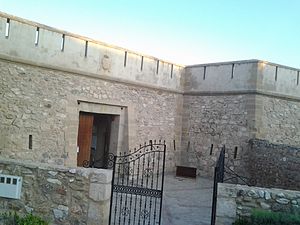
Castillo de las Escobetas
Castle in Garrucha, Andalusia, Spain
Distance: Approx. 996 meters
Latitude and longitude: 37.1725,-1.823611
Castillo de las Escobetas ("Castle of the Nazarene") is located 3.25 miles (5.23 km) northward of Cantal Point, in the town of Garrucha, Almería province, in the autonomous community of Andalusia, Spain. The fishing village of Garrucha suffered at the hands of Berber pirates until the year 1766 when barracks were built at Escobetas, a provisional military building which cost 13,970 reais. In 1769, the castle was completed at a cost of 181,000 reais.
Desert Springs Cricket Ground
Cricket ground
Distance: Approx. 7937 meters
Latitude and longitude: 37.25269444,-1.82313889
The Desert Springs Cricket Ground is a sports ground in Palomares, Cuevas del Almanzora, Almería, Spain. In September 2019, it was selected to host Germany's tour of Spain in March 2020, which included two Twenty20 International (T20I) cricket matches between Spain and Germany. The first international cricket match on the venue was the two teams' first T20I on March 8.
Weather in this IP's area
scattered clouds
15 Celsius
14 Celsius
15 Celsius
15 Celsius
1017 hPa
64 %
1017 hPa
1008 hPa
10000 meters
7.5 m/s
9.09 m/s
207 degree
29 %