Country:
Region:
City:
Latitude and Longitude:
Time Zone:
Postal Code:
IP information under different IP Channel
ip-api
Country
Region
City
ASN
Time Zone
ISP
Blacklist
Proxy
Latitude
Longitude
Postal
Route
Luminati
Country
ASN
Time Zone
Europe/London
ISP
VeloxServ Communications Ltd
Latitude
Longitude
Postal
IPinfo
Country
Region
City
ASN
Time Zone
ISP
Blacklist
Proxy
Latitude
Longitude
Postal
Route
db-ip
Country
Region
City
ASN
Time Zone
ISP
Blacklist
Proxy
Latitude
Longitude
Postal
Route
ipdata
Country
Region
City
ASN
Time Zone
ISP
Blacklist
Proxy
Latitude
Longitude
Postal
Route
Popular places and events near this IP address

Public Record Office
National archive service of the United Kingdom from 1838 until 2003
Distance: Approx. 105 meters
Latitude and longitude: 51.5153,-0.1106
The Public Record Office (abbreviated as PRO, pronounced as three letters and referred to as the PRO), Chancery Lane in the City of London, was the guardian of the national archives of the United Kingdom from 1838 until 2003, when it was merged with the Historical Manuscripts Commission to form The National Archives, based in Kew. It was under the control of the Master of the Rolls, a senior judge. The Public Record Office still exists as a legal entity, as the enabling legislation has not been modified.

St Dunstan-in-the-West
Church in City of London, England
Distance: Approx. 122 meters
Latitude and longitude: 51.51425,-0.11022222
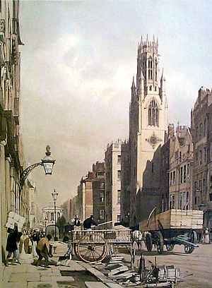
The Guild Church of St Dunstan-in-the-West is in Fleet Street in the City of London. It is dedicated to Dunstan, Bishop of London and Archbishop of Canterbury. The church is of medieval origin, although the present building, with an octagonal nave, was constructed in the 1830s to the designs of John Shaw.
Multimap.com
Distance: Approx. 79 meters
Latitude and longitude: 51.51453,-0.10845
Multimap.com was a provider of mapping and location-based services. Founded around 1997 and based in London, it was acquired by Microsoft in 2007 for $50 million. It was then merged into Bing Maps.

Dr Johnson's House
Distance: Approx. 75 meters
Latitude and longitude: 51.515,-0.10805556
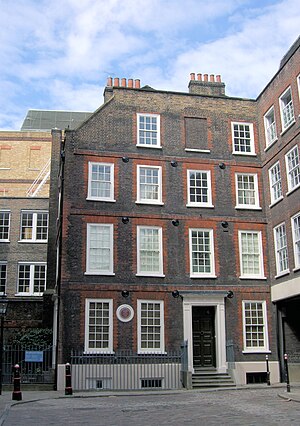
Dr Johnson's House is a writer's house museum in London in the former home of the 18th-century English writer and lexicographer Samuel Johnson. The house is a Grade I listed building.
Dorset Garden Theatre
Historic London theatre
Distance: Approx. 127 meters
Latitude and longitude: 51.51416667,-0.10805556
The Dorset Garden Theatre in London, built in 1671, was in its early years also known as the Duke of York's Theatre, or the Duke's Theatre. In 1685, King Charles II died and his brother, the Duke of York, was crowned as James II. When the Duke became King, the theatre became the Queen's Theatre in 1685, referring to James' second wife, Mary of Modena. The name remained when William III and Mary II came to the throne in 1689.

Farringdon Without
Ward of the City of London
Distance: Approx. 130 meters
Latitude and longitude: 51.51627,-0.10911
Farringdon Without is the most westerly ward of the City of London, England. Its suffix Without reflects its origin as lying beyond the City's former defensive walls. It was first established in 1394 to administer the suburbs west of Ludgate and Newgate, including West Smithfield and Temple.

Maughan Library
Main academic and research library of King's College London
Distance: Approx. 105 meters
Latitude and longitude: 51.5153,-0.1106
The Maughan Library () is the main university research library of King's College London, forming part of the Strand Campus. A 19th-century neo-Gothic building located on Chancery Lane in the City of London, it was formerly the home to the headquarters of the Public Record Office, known as the "strong-box of the Empire", and was acquired by the university in 2001. Following a £35m renovation designed by Gaunt Francis Architects, the Maughan is the largest new university library in the United Kingdom since World War II. Designed by Sir James Pennethorne and constructed in 1851, with further extensions made between 1868 and 1900, it is a Grade II* listed building.

Holy Trinity Gough Square
Distance: Approx. 40 meters
Latitude and longitude: 51.51527778,-0.10861111
Holy Trinity Gough Square was a Victorian church in the City of London.

Fetter Lane
Street in the City of London
Distance: Approx. 35 meters
Latitude and longitude: 51.515,-0.1096
Fetter Lane is a street in the ward of Farringdon Without in the City of London, England. It forms part of the A4 road and runs between Fleet Street at its southern end and Holborn.
London Press Club
Members' club in London, England
Distance: Approx. 134 meters
Latitude and longitude: 51.51509722,-0.10718611
The London Press Club was established in 1882 as a London gentlemen's club. For much of its history, it occupied premises in Wine Office Court, near Fleet Street. It still exists today, as a society for journalists, but no longer offers club facilities, which ended with its leaving Wine Office Court in 1986.

Rolls Building
Court building in London, England
Distance: Approx. 98 meters
Latitude and longitude: 51.5159,-0.1097
The Rolls Building is a judicial court complex on Fetter Lane in the City of London that is used by the High Court of Justice (one of the Senior Courts of England and Wales). It houses the commercial and property business of the Chancery Division (including bankruptcy), as well as the Admiralty Court, Commercial Court, and the Technology and Construction Court. The building has 31 courtrooms, including three "super courts" for high-value cases, and four landscape-oriented courtrooms for multi-party cases.

El Vino
Wine bar in Fleet Street
Distance: Approx. 123 meters
Latitude and longitude: 51.514,-0.1092
El Vino, also known as El Vino's, is a wine bar and off-licence in London's Fleet Street that was famously patronised by journalists when many national newspapers were based nearby. It is still patronised by lawyers as the surrounding area is still London's legal district. The business was founded by the wine merchant Alfred Bower in Mark Lane as Bower and Co.
Weather in this IP's area
broken clouds
10 Celsius
7 Celsius
9 Celsius
11 Celsius
1016 hPa
79 %
1016 hPa
1012 hPa
10000 meters
5.14 m/s
270 degree
75 %
07:22:34
16:08:39
