Country:
 Czech Republic
Region:
City:
Latitude and Longitude:
Time Zone:
Postal Code:
IP information under different IP Channel
ip-api
Country
Region
City
ASN
Time Zone
ISP
Blacklist
Proxy
Latitude
Longitude
Postal
Route
IPinfo
Country
Region
City
ASN
Time Zone
ISP
Blacklist
Proxy
Latitude
Longitude
Postal
Route
MaxMind
Country
Region
City
ASN
Time Zone
ISP
Blacklist
Proxy
Latitude
Longitude
Postal
Route
Luminati
Country
CZRegion
20
City
cernosice
ASN
Time Zone
Europe/Prague
ISP
WIA spol. s.r.o.
Latitude
Longitude
Postal
db-ip
Country
Region
City
ASN
Time Zone
ISP
Blacklist
Proxy
Latitude
Longitude
Postal
Route
ipdata
Country
Region
City
ASN
Time Zone
ISP
Blacklist
Proxy
Latitude
Longitude
Postal
Route
Popular places and events near this IP address
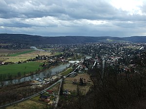
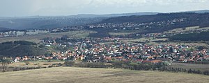
Černošice
Town in Central Bohemian, Czech Republic
Distance: Approx. 529 meters
Latitude and longitude: 49.95305556,14.32527778
Černošice (Czech pronunciation: [ˈtʃɛrnoʃɪtsɛ]) is a town in Prague-West District in the Central Bohemian Region of the Czech Republic. It has about 7,700 inhabitants.

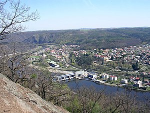
Dobřichovice
Town in Central Bohemian, Czech Republic
Distance: Approx. 4805 meters
Latitude and longitude: 49.9275,14.27722222
Dobřichovice is a town in Prague-West District in the Central Bohemian Region of the Czech Republic. It has about 3,800 inhabitants.

Prague-West District
District in the Czech Republic
Distance: Approx. 3260 meters
Latitude and longitude: 49.93333333,14.3
Prague-West District (Czech: okres Praha-západ) is a district in the Central Bohemian Region of the Czech Republic. Its capital is Prague. The most populated town of the district is Jesenice.
Choteč (Prague-West District)
Municipality in Central Bohemian, Czech Republic
Distance: Approx. 4398 meters
Latitude and longitude: 49.98666667,14.28305556
Choteč is a municipality and village in Prague-West District in the Central Bohemian Region of the Czech Republic. It has about 400 inhabitants.

Jíloviště
Municipality in Central Bohemian, Czech Republic
Distance: Approx. 3605 meters
Latitude and longitude: 49.9275,14.34277778
Jíloviště is a municipality and village in Prague-West District in the Central Bohemian Region of the Czech Republic. It has about 700 inhabitants.
Kosoř
Municipality in Central Bohemian, Czech Republic
Distance: Approx. 3308 meters
Latitude and longitude: 49.9875,14.32666667
Kosoř is a municipality and village in Prague-West District in the Central Bohemian Region of the Czech Republic. It has about 900 inhabitants.

Třebotov
Municipality in Central Bohemian, Czech Republic
Distance: Approx. 2910 meters
Latitude and longitude: 49.9725,14.29138889
Třebotov is a municipality and village in Prague-West District in the Central Bohemian Region of the Czech Republic. It has about 1,500 inhabitants.

Vonoklasy
Municipality in Central Bohemian, Czech Republic
Distance: Approx. 3569 meters
Latitude and longitude: 49.95,14.27666667
Vonoklasy is a municipality and village in Prague-West District in the Central Bohemian Region of the Czech Republic. It has about 600 inhabitants.
Vrané nad Vltavou
Municipality in Central Bohemian, Czech Republic
Distance: Approx. 4469 meters
Latitude and longitude: 49.93583333,14.37722222
Vrané nad Vltavou is a municipality and village in Prague-West District in the Central Bohemian Region of the Czech Republic. It has about 2,700 inhabitants.

Všenory
Municipality in Central Bohemian, Czech Republic
Distance: Approx. 3556 meters
Latitude and longitude: 49.92888889,14.30388889
Všenory is a municipality and village in Prague-West District in the Central Bohemian Region of the Czech Republic. It has about 1,700 inhabitants.

Prague 16
Place in Prague, Czech Republic
Distance: Approx. 3758 meters
Latitude and longitude: 49.98416667,14.35777778
Prague 16 is a municipal district (městská část) of Prague. It has about 8,500 inhabitants. It is located in the south-western part of the city.
Lipence
Municipal District of Prague in Czech Republic
Distance: Approx. 2383 meters
Latitude and longitude: 49.9602778,14.3580556
Lipence is a municipal district (městská část) in Prague, Czech Republic.
Weather in this IP's area
overcast clouds
9 Celsius
7 Celsius
8 Celsius
10 Celsius
1017 hPa
95 %
1017 hPa
992 hPa
8000 meters
4.12 m/s
350 degree
100 %
07:09:02
18:32:47