Country:
 Switzerland
Region:
City:
Latitude and Longitude:
Time Zone:
Postal Code:
IP information under different IP Channel
ip-api
Country
Region
City
ASN
Time Zone
ISP
Blacklist
Proxy
Latitude
Longitude
Postal
Route
IPinfo
Country
Region
City
ASN
Time Zone
ISP
Blacklist
Proxy
Latitude
Longitude
Postal
Route
MaxMind
Country
Region
City
ASN
Time Zone
ISP
Blacklist
Proxy
Latitude
Longitude
Postal
Route
Luminati
Country
CHRegion
zh
City
zurich
ASN
Time Zone
Europe/Zurich
ISP
Init7 (Switzerland) Ltd.
Latitude
Longitude
Postal
db-ip
Country
Region
City
ASN
Time Zone
ISP
Blacklist
Proxy
Latitude
Longitude
Postal
Route
ipdata
Country
Region
City
ASN
Time Zone
ISP
Blacklist
Proxy
Latitude
Longitude
Postal
Route
Popular places and events near this IP address

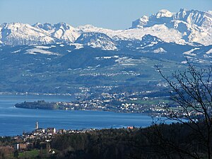
Lake Zurich
Major lake in Switzerland
Distance: Approx. 1907 meters
Latitude and longitude: 47.2475,8.6775
Lake Zurich (German: Zürichsee; Alemannic German: Zürisee) is a lake in Switzerland, extending southeast of the city of Zurich. Depending on the context, Lake Zurich or Zürichsee can be used to describe the lake as a whole, or just that part of the lake downstream of the Hurden peninsula and Seedamm causeway (between Pfäffikon and Rapperswil). In the latter case, the upstream part of the lake is called Obersee (lit. 'Upper Lake'), whilst the lower part is sometimes also referred to as the Lower Lake (unterer Zürichsee), respectively.

Männedorf
Municipality in Zurich, Switzerland
Distance: Approx. 2251 meters
Latitude and longitude: 47.25,8.68333333
Männedorf (High Alemannic: Mänidoorf) is a municipality in the district of Meilen in the canton of Zürich in Switzerland.

Richterswil
Municipality in Zürich, Switzerland
Distance: Approx. 2373 meters
Latitude and longitude: 47.21666667,8.7
Richterswil (Swiss German: Richtischwiil ) is a municipality in the district of Horgen in the canton of Zürich in Switzerland.

Wädenswil
Municipality in Zürich, Switzerland
Distance: Approx. 777 meters
Latitude and longitude: 47.23333333,8.66666667
Wädenswil (locally often called Wättischwiil, Wädischwiil or Wädi) is a municipality located in the district of Horgen in the canton of Zürich in Switzerland. The population, as of 2013, was about 21,000. On 1 January 2019 the former municipalities of Hütten and Schönenberg were merged into the municipality of Wädenswil.

Au, Zürich
Former municipality in Zürich, Switzerland
Distance: Approx. 2943 meters
Latitude and longitude: 47.241,8.64033333
Au is a village in the municipality Wädenswil in the district of Horgen in the canton of Zürich in Switzerland. First mentioned in the year 1130 as "Naglikon" and in 1316 as "Owe", Au (Lauft) belongs politically to the urban area of the south-eastern city of Wädenswil on Lake Zürich.
Au Peninsula
Swiss peninsula
Distance: Approx. 3077 meters
Latitude and longitude: 47.24916667,8.64611111
The Au Peninsula (German: Halbinsel Au) is located on the Swiss Zürichsee lake shore in the municipality of Au, Canton of Zürich.

Alt Wädenswil Castle
Distance: Approx. 2024 meters
Latitude and longitude: 47.213115,8.684284
Alt Wädenswil Castle (German: Ruine Alt-Wädenswil) is a castle in the municipality of Richterswil and the canton of Zurich in Switzerland. It is a Swiss heritage site of national significance.

Au ZH railway station
Railway station in the canton of Zürich, Switzerland
Distance: Approx. 3049 meters
Latitude and longitude: 47.24681111,8.6437
Au ZH railway station (German: Bahnhof Au ZH) is a railway station in Switzerland, situated in the village of Au in the municipality of Wädenswil in the canton of Zürich (abbreviated to ZH). The station is located on the Lake Zürich left bank railway line, and is served by line S8 of the Zürich S-Bahn. As conventions change, the station's name "Au ZH" was previously written "Au (ZH)" or "Au (Zürich)".
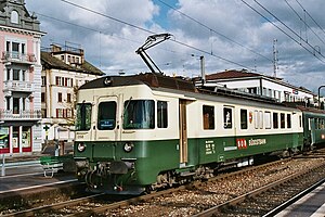
Wädenswil railway station
Railway station in Switzerland
Distance: Approx. 137 meters
Latitude and longitude: 47.2293,8.6751795
Wädenswil railway station is a railway station in Switzerland, situated near to the banks of Lake Zurich in the municipality of Wädenswil in the canton of Zurich. It is located on the Lake Zurich left bank railway line, and is the junction station for the Südostbahn's Wädenswil to Einsiedeln line. The station is served on the lakeside line by an hourly long-distance InterRegio service between Bern and Chur.
Männedorf railway station
Railway station in Switzerland
Distance: Approx. 2850 meters
Latitude and longitude: 47.253474,8.692353
Männedorf is a railway station in the Swiss canton of Zurich, situated in the municipality of Männedorf. The station is located on the Lake Zurich right bank railway line.

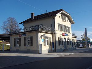
Burghalden railway station
Railway station in the canton of Zürich, Switzerland
Distance: Approx. 2736 meters
Latitude and longitude: 47.208658,8.692862
Burghalden is a railway station in the Swiss canton of Zurich and municipality of Richterswil. It is located on the Südostbahn's Wädenswil to Einsiedeln line, and is served by Zurich S-Bahn line S13.

Wädenswil–Vorder Au
UNESCO World Heritage Site in Canton of Zürich, Switzerland
Distance: Approx. 2518 meters
Latitude and longitude: 47.24691389,8.65323611
Wädenswil–Vorder Au is one of the 111 serial sites of the UNESCO World Heritage Site Prehistoric pile dwellings around the Alps, of which 56 are located in Switzerland.
Weather in this IP's area
fog
11 Celsius
11 Celsius
9 Celsius
12 Celsius
1017 hPa
93 %
1017 hPa
968 hPa
750 meters
27 %
07:49:30
18:30:35