Country:
 Switzerland
Region:
City:
Latitude and Longitude:
Time Zone:
Postal Code:
IP information under different IP Channel
ip-api
Country
Region
City
ASN
Time Zone
ISP
Blacklist
Proxy
Latitude
Longitude
Postal
Route
IPinfo
Country
Region
City
ASN
Time Zone
ISP
Blacklist
Proxy
Latitude
Longitude
Postal
Route
MaxMind
Country
Region
City
ASN
Time Zone
ISP
Blacklist
Proxy
Latitude
Longitude
Postal
Route
Luminati
Country
CHASN
Time Zone
Europe/Zurich
ISP
green.ch AG
Latitude
Longitude
Postal
db-ip
Country
Region
City
ASN
Time Zone
ISP
Blacklist
Proxy
Latitude
Longitude
Postal
Route
ipdata
Country
Region
City
ASN
Time Zone
ISP
Blacklist
Proxy
Latitude
Longitude
Postal
Route
Popular places and events near this IP address

Reuss (river)
River in Switzerland
Distance: Approx. 2011 meters
Latitude and longitude: 47.4909,8.23193
The Reuss (German pronunciation: [ʁɔɪ̯s] ; Swiss German: Rüüss) is a river in Switzerland. With a length of 164 kilometres (102 mi) and a drainage basin of 3,426 square kilometres (1,323 sq mi), it is the fourth largest river in Switzerland (after the Rhine, Aare and Rhône). The upper Reuss forms the main valley of the canton of Uri.
Brugg District
District in Switzerland
Distance: Approx. 543 meters
Latitude and longitude: 47.48333333,8.2
Brugg District is a district in the Canton of Aargau, Switzerland. The capital of the district is the town of Brugg.

Brugg
Municipality in Aargau, Switzerland
Distance: Approx. 246 meters
Latitude and longitude: 47.48638889,8.20666667
Brugg (sometimes written as Brugg AG in order to distinguish it from other Bruggs) is a Swiss municipality and a town in the canton of Aargau and is the seat of the district of the same name. The town is located at the confluence of the Aare, Reuss, and Limmat, with the Aare flowing through its medieval part. It is located approximately 16 kilometers (9.9 mi) from the cantonal capital of Aarau; 28 kilometers (17 mi) from Zürich; and about 45 kilometers (28 mi) from Basel.
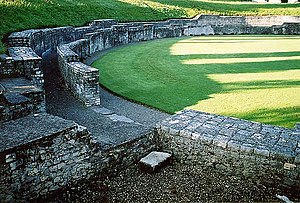
Vindonissa
Former Roman legion camp in Switzerland
Distance: Approx. 1199 meters
Latitude and longitude: 47.480464,8.222051
Vindonissa (from a Gaulish toponym in *windo- "white") was a Roman legion camp, vicus and later a bishop's seat at modern Windisch, Switzerland. The remains of the camp are listed as a heritage site of national significance. The city of Brugg hosts a small Roman museum, displaying finds from the legion camp.
Battle of Vindonissa
Battle between Roman and Alemanni forces (298/302)
Distance: Approx. 2080 meters
Latitude and longitude: 47.46666694,8.21666694
The Battle of Vindonissa was fought in 298 or 302 between the Imperial Roman army, led by Emperor Constantius Chlorus, and the Alemanni. The Romans won the battle, fought in Vindonissa, strengthening Rome's defenses along the Rhine.

Windisch, Switzerland
Place in Aargau, Switzerland
Distance: Approx. 726 meters
Latitude and longitude: 47.48333333,8.21666667
Windisch is a municipality in the district of Brugg in the canton of Aargau in Switzerland.

Gebenstorf
Municipality in Aargau, Switzerland
Distance: Approx. 1976 meters
Latitude and longitude: 47.48333333,8.23333333
Gebenstorf is a municipality in the district of Baden in the canton of Aargau in Switzerland.

Umiken
Former municipality in Aargau, Switzerland
Distance: Approx. 543 meters
Latitude and longitude: 47.48333333,8.2
Umiken was a municipality in the district of Brugg in the canton of Aargau in Switzerland. On 1 January 2010 the municipality of Umiken merged into Brugg.
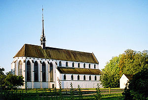
Königsfelden Monastery
Distance: Approx. 933 meters
Latitude and longitude: 47.48027778,8.21805556
Königsfelden Monastery is a former Franciscan double monastery, which housed both a community of Poor Clare nuns and one of Franciscan friars, living in separate wings, in the municipality of Windisch in the canton of Aargau in Switzerland. It was founded in 1308 by the Habsburgs. In the course of the Protestant Reformation in Switzerland in 1528 it was secularized, and the complex was then the residence of the bailiffs of Bern.
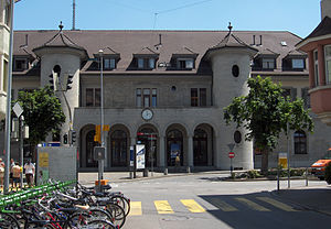
Brugg AG railway station
Railway station in Switzerland
Distance: Approx. 395 meters
Latitude and longitude: 47.48085,8.20881806
Brugg AG railway station (German: Bahnhof Brugg AG) serves the municipality of Brugg, in the canton of Aargau, Switzerland. Opened in 1856, it is owned and operated by Swiss Federal Railways. The station forms the junction between the Baden–Aarau railway, part of the original line between Zurich and Olten, the Bözberg railway line (German: Bözbergstrecke), which links Basel SBB with Brugg, and the Brugg–Hendschiken line, which links Brugg with Rotkreuz.

Altenburg Castle
Distance: Approx. 990 meters
Latitude and longitude: 47.48201111,8.19433889
Altenburg Castle is a castle in the village of Altenburg bei Brugg in the municipality of Brugg in the canton of Aargau in Switzerland. The castle (the Schlössli) and the Altenburg Roman ruins, which are integrated into it, are classified as Swiss heritage site of national significance.
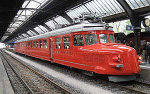
SBB Historic
Distance: Approx. 984 meters
Latitude and longitude: 47.4754,8.2059
SBB Historic is a foundation aiming at preserving historical documents and artefacts from the history of Swiss railway transportation. It was founded by the Swiss Federal Railways (SBB) in 2001 and it is based in Windisch.
Weather in this IP's area
overcast clouds
20 Celsius
20 Celsius
19 Celsius
21 Celsius
1010 hPa
90 %
1010 hPa
969 hPa
8223 meters
0.94 m/s
1.53 m/s
269 degree
100 %
06:55:41
19:54:12