Country:
Region:
City:
Latitude and Longitude:
Time Zone:
Postal Code:
IP information under different IP Channel
ip-api
Country
Region
City
ASN
Time Zone
ISP
Blacklist
Proxy
Latitude
Longitude
Postal
Route
Luminati
Country
ASN
Time Zone
Europe/Warsaw
ISP
MSI Telekom Sp. z o.o. Sp. k.
Latitude
Longitude
Postal
IPinfo
Country
Region
City
ASN
Time Zone
ISP
Blacklist
Proxy
Latitude
Longitude
Postal
Route
db-ip
Country
Region
City
ASN
Time Zone
ISP
Blacklist
Proxy
Latitude
Longitude
Postal
Route
ipdata
Country
Region
City
ASN
Time Zone
ISP
Blacklist
Proxy
Latitude
Longitude
Postal
Route
Popular places and events near this IP address

Olsztyn
Place in Warmian-Masurian Voivodeship, Poland
Distance: Approx. 2216 meters
Latitude and longitude: 53.77777778,20.47916667
Olsztyn (UK: OL-shtin, Polish: [ˈɔlʂtɨn] ; German: Allenstein [ˈʔalənʃtaɪn] ; Old Prussian: Alnāsteini ) is a city on the Łyna River in northern Poland. It is the capital of the Warmian-Masurian Voivodeship, and is a city with county rights. The population of the city was estimated at 169,793 residents in 2021.

Olsztyn Voivodeship
Former administrative unit in Poland
Distance: Approx. 2310 meters
Latitude and longitude: 53.783333,20.483333
Olsztyn Voivodeship (Polish: województwo olsztyńskie) was an administrative division and unit of local government in Poland in the years 1945–75, and a new territorial division between 1975–1998, superseded by Warmian-Masurian Voivodeship. Its capital city was Olsztyn. From 1945 to 1975 the Olsztyn Voivodeship covered a larger area.

Olsztyn County
County in Warmian-Masurian Voivodeship, Poland
Distance: Approx. 1636 meters
Latitude and longitude: 53.78333333,20.5
Olsztyn County (Polish: powiat olsztyński) is a unit of territorial administration and local government (powiat) in Warmian-Masurian Voivodeship, northern Poland. It came into being on January 1, 1999, as a result of the Polish local government reforms passed in 1998. Its administrative seat is the city of Olsztyn, although the city is not part of the county (it constitutes a separate city county).

OSiR Stadium (Olsztyn)
Distance: Approx. 351 meters
Latitude and longitude: 53.773025,20.50941111
Stadium OSiR w Olsztynie (OSiR Stadium in Olsztyn) is a multi-use stadium in Olsztyn, Poland. It is currently used mostly for football matches and is the home ground of OKS 1945 Olsztyn. The stadium has a capacity of 16,800 people.

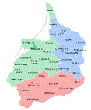
Allenstein (region)
Governmental district of East Prussia from 1905 to 1945
Distance: Approx. 2313 meters
Latitude and longitude: 53.75,20.5
Regierungsbezirk Allenstein was a Regierungsbezirk, or government region, of the Prussian province of East Prussia from 1905 until 1945. The regional capital was Allenstein (present-day Olsztyn). The territory today is part of the Polish Warmian-Masurian Voivodeship.
Roman Catholic Archdiocese of Warmia
Catholic archdiocese in Poland
Distance: Approx. 2253 meters
Latitude and longitude: 53.7761,20.4775
The Archdiocese of Warmia (Polish: Archidiecezja warmińska, German: Erzdiözese Ermland) is a Latin Church Metropolitan archdiocese of the Catholic Church in the Warmian-Masurian Voivodeship, Poland. The archbishop has his Cathedral archiepiscopal see: Bazylika Archikatedralna Wniebowzięcia NMP i św. Andrzeja Apostoła, in the town of Frombork, and a co-cathedral Bazylika Konkatedralna św.
Ostrzeszewo
Village in Warmian-Masurian Voivodeship, Poland
Distance: Approx. 1773 meters
Latitude and longitude: 53.76722222,20.53666667
Ostrzeszewo [ɔstʂɛˈʂɛvɔ] is a village in the administrative district of Gmina Purda, within Olsztyn County, Warmian-Masurian Voivodeship, in northern Poland. It is located within the historic region of Warmia. Before 1772 the area was part of Kingdom of Poland, from 1772 of Prussia, after 1871 of Germany, and after 1945 of Poland.

Mendelsohn House
Building in Olsztyn, Poland
Distance: Approx. 2812 meters
Latitude and longitude: 53.77527778,20.46833333
The Mendelsohn House (Polish: Dom Mendelsohna) is a former Jewish Tahara house (Bet Tahara) in Olsztyn, Poland, today used as a center for intercultural dialogue. It also includes a gatehouse.

Olsztyn Castle
Castle in Warmian-Masurian Voivodeship, Poland
Distance: Approx. 2880 meters
Latitude and longitude: 53.76666667,20.46666667
The Olsztyn Castle, officially the Castle of Warmian Cathedral Chapter in Olsztyn (Polish: Zamek Kapituły Warmińskiej w Olsztynie), is a Brick Gothic castle located in the heart of Olsztyn, in northern Poland. Built in the 14th century, it served as the seat for administrators of property of the Warmian Cathedral Chapter. The most well-known administrator caretaker was Nicolaus Copernicus, a canon of Warmian Cathedral Chapter in Frombork, who resided here between 1516 and 1521.
Olsztyn Główny railway station
Railway station in Olsztyn, Poland
Distance: Approx. 1947 meters
Latitude and longitude: 53.7856553,20.4972517
Olsztyn Główny (Polish for Olsztyn Main station) is a railway station of Olsztyn, Warmian-Masurian Voivodeship, Poland. According to the classification of passenger stations in Poland, it belongs to Voivodeship station. In 2018, the station served approximately 7,900 passengers a day.

Trams in Olsztyn
Public transport in Olsztyn, Poland
Distance: Approx. 1204 meters
Latitude and longitude: 53.7807,20.509
The tram network in Olsztyn, Poland, is operated by the city-owned Olsztyn Municipal Transport Company (Polish: Miejskie Przedsiębiorstwo Komunikacyjne Olsztyn) Sp. z o.o. The system contains five lines.

Co-Cathedral Basilica of St. James in Olsztyn
Church in Olsztyn, Poland
Distance: Approx. 2228 meters
Latitude and longitude: 53.77588889,20.47777778
The Co-Cathedral Basilica of St. James in Olsztyn (Polish: Bazylika konkatedralna św. Jakuba Apostoła w Olsztynie) is a Catholic basilica and co-cathedral in Olsztyn, Poland.
Weather in this IP's area
overcast clouds
7 Celsius
3 Celsius
7 Celsius
7 Celsius
1022 hPa
55 %
1022 hPa
1006 hPa
10000 meters
6.94 m/s
14.98 m/s
256 degree
89 %
06:42:10
16:00:48


