Country:
Region:
City:
Latitude and Longitude:
Time Zone:
Postal Code:
IP information under different IP Channel
ip-api
Country
Region
City
ASN
Time Zone
ISP
Blacklist
Proxy
Latitude
Longitude
Postal
Route
Luminati
Country
Region
10
City
bangkok
ASN
Time Zone
Asia/Bangkok
ISP
CSNE Co., Ltd.
Latitude
Longitude
Postal
IPinfo
Country
Region
City
ASN
Time Zone
ISP
Blacklist
Proxy
Latitude
Longitude
Postal
Route
db-ip
Country
Region
City
ASN
Time Zone
ISP
Blacklist
Proxy
Latitude
Longitude
Postal
Route
ipdata
Country
Region
City
ASN
Time Zone
ISP
Blacklist
Proxy
Latitude
Longitude
Postal
Route
Popular places and events near this IP address

National Institute of Development Administration
Business school
Distance: Approx. 4666 meters
Latitude and longitude: 13.769621,100.652622
The National Institute of Development Administration (NIDA) Thai: สถาบันบัณฑิตพัฒนบริหารศาสตร์) is the only public higher education institution in Thailand that teaches only at the graduate level (postgraduate) with a strong emphasis on Management, Economics and Sustainable Development. It also has duties in research, training, and other academic services. To government agencies, state enterprises, private businesses and the general public.

Bueng Kum district
Khet in Bangkok, Thailand
Distance: Approx. 2330 meters
Latitude and longitude: 13.78527778,100.66916667
Bueng Kum (Thai: บึงกุ่ม, pronounced [bɯ̄ŋ kùm]) is one of the 50 districts (Khet) of Bangkok, Thailand. From north clockwise, it is bounded by Bang Khen, Khan Na Yao, Saphan Sung, Bang Kapi, and Lat Phrao.

Saphan Sung district
Khet in Bangkok, Thailand
Distance: Approx. 4076 meters
Latitude and longitude: 13.77,100.68472222
Saphan Sung (Thai: สะพานสูง, pronounced [sā.pʰāːn sǔːŋ]) is one of the 50 districts (khet) of Bangkok, Thailand. Located on the eastern part of the capital, it is bounded by other Bangkok districts (from north clockwise): Khan Na Yao, Min Buri, Lat Krabang, Prawet, Suan Luang, Bang Kapi, and Bueng Kum. Most part of Saphan Sung district are low density residential area.

Siam Amazing Park
Amusement and water park in the Khan Na Yao District of Bangkok, Thailand
Distance: Approx. 2392 meters
Latitude and longitude: 13.805242,100.697229
Siam Amazing Park (Thai: สยามอะเมซิ่งพาร์ค), more commonly known as Siam Park City or Suansiam (สวนสยาม, RTGS: Suan Sayam, pronounced [sǔa̯n sā.jǎːm]), is an amusement and water park located in the Khan Na Yao district of Bangkok, Thailand. It was founded in November 1980 and remains the oldest amusement and water park complex in Southeast Asia. Located near Bangkok's Suvarnabhumi Airport, it contains attractions such as Southeast Asia's first suspended looping coaster with five inversions, a large wave pool and seven-story slides.

Fashion Island (Bangkok)
Shopping mall in Bangkok
Distance: Approx. 2312 meters
Latitude and longitude: 13.825803,100.679096
Fashion Island is a shopping mall located on Ramintra Road, in Khan Na Yao District outskirt of Bangkok, Thailand. Fashion Island is currently ranked as the Twenty-sixth largest mall in the World along with Dubai Mall and West Edmonton Mall (once biggest mall in the world until 2004). The shopping mall featured an amusement park with a monorail circling around the mall.
Niva International School
Private school in Bangkok, Thailand
Distance: Approx. 4526 meters
Latitude and longitude: 13.803033,100.633307
NIVA American International School (Thai: โรงเรียนนานาชาตินีวาอเมริกัน, RTGS: Rong Rian Nana Chat Niwa Amerikan) is a privately owned coeducational school located in Bang Kapi District, Bangkok, Thailand. NIVA is a K-12 school with approximately 350 students. The international school was founded in 1991.

Wat Bueng Thonglang
Buddhist temple in Bangkok, Thailand
Distance: Approx. 5296 meters
Latitude and longitude: 13.79666667,100.62694444
Wat Bueng Thonglang (Thai: วัดบึงทองหลาง, pronounced [wát bɯ̄ŋ tʰɔ̄ːŋ.lǎːŋ]) is a Buddhist temple in Bang Kapi District, Bangkok, Thailand. It was measured under Theravada School, Section of Maha Nikai. It is located at Lat Phrao 101 Road.

Khwan Riam Floating Market
Distance: Approx. 3819 meters
Latitude and longitude: 13.8001,100.71
Khwan Riam Floating Market (Thai: ตลาดน้ำขวัญเรียม, pronounced [tā.làːt náːm kʰwǎn rīam]) is one of the central floating markets of Bangkok, Thailand. It located between Soi Seri Thai 60 and Soi Ramkhamhaeng 187 in Min Buri District, eastern Bangkok. The name of the market "Khwan Riam" comes from the name of main characters in Thai romance-drama novel titled Phlae Kao.
Klong Chan Sports Center
Multi-purpose stadium in Thailand
Distance: Approx. 4455 meters
Latitude and longitude: 13.778111,100.644962
Klong Chan Sports Center (Thai: สนามกีฬาการเคหะแห่งชาติคลองจั่น) is a multi-purpose stadium in Bang Kapi, Bangkok, Thailand. It is currently used mostly for football matches.

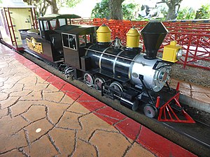
Siam Park City Railway
Miniature railway in Bangkok, Thailand
Distance: Approx. 1936 meters
Latitude and longitude: 13.805675,100.693003
Siam Amazing Park Railway is a former miniature railway at Siam Park City in Bangkok.
Nopparat Rajathanee Hospital
Hospital in Bangkok , Thailand
Distance: Approx. 1937 meters
Latitude and longitude: 13.817454,100.688026
Nopparat Rajathanee Hospital (Thai: โรงพยาบาลนพรัตนราชธานี) is a hospital located in Khan Na Yao District, Bangkok, Thailand. It is a main teaching hospital for the College of Medicine, Rangsit University. It is also an affiliated teaching hospital of the Faculty of Medicine Siriraj Hospital, Mahidol University, the Faculty of Medicine, Srinakharinwirot University and Phramongkutklao College of Medicine.

Min Buri subdistrict
Khwaeng in Thailand
Distance: Approx. 4665 meters
Latitude and longitude: 13.81266667,100.71759722
Min Buri (Thai: แขวงมีนบุรี, pronounced [kʰwɛ̌ːŋ mīːn būrīː]) is a khwaeng (subdistrict) of Min Buri district, Bangkok, Thailand.
Weather in this IP's area
light rain
30 Celsius
33 Celsius
30 Celsius
30 Celsius
1011 hPa
62 %
1011 hPa
1010 hPa
10000 meters
4.12 m/s
30 degree
20 %
06:14:19
17:47:50