82.151.33.165 - IP Lookup: Free IP Address Lookup, Postal Code Lookup, IP Location Lookup, IP ASN, Public IP
Country:
Region:
City:
Location:
Time Zone:
Postal Code:
ISP:
ASN:
language:
User-Agent:
Proxy IP:
Blacklist:
IP information under different IP Channel
ip-api
Country
Region
City
ASN
Time Zone
ISP
Blacklist
Proxy
Latitude
Longitude
Postal
Route
db-ip
Country
Region
City
ASN
Time Zone
ISP
Blacklist
Proxy
Latitude
Longitude
Postal
Route
IPinfo
Country
Region
City
ASN
Time Zone
ISP
Blacklist
Proxy
Latitude
Longitude
Postal
Route
IP2Location
82.151.33.165Country
Region
noord-holland
City
den oever
Time Zone
Europe/Amsterdam
ISP
Language
User-Agent
Latitude
Longitude
Postal
ipdata
Country
Region
City
ASN
Time Zone
ISP
Blacklist
Proxy
Latitude
Longitude
Postal
Route
Popular places and events near this IP address

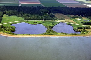
Wieringen
Former municipality in North Holland, Netherlands
Distance: Approx. 5528 meters
Latitude and longitude: 52.9,4.97
Wieringen (Dutch pronunciation: [ˈʋiːrɪŋə(n)] ) is located in the province of North Holland in the Netherlands. Now a part of the municipality of Hollands Kroon, it was a separate municipality before 2012. Its name first appeared in 8th and 9th century records.

Inundation of the Wieringermeer
Distance: Approx. 5715 meters
Latitude and longitude: 52.89,5.076
On 17 April 1945, the retreating German occupying forces inundated the polder of Wieringermeer, the Netherlands.

Hippolytushoef
Town in North Holland, Netherlands
Distance: Approx. 5695 meters
Latitude and longitude: 52.9,4.96666667
Hippolytushoef, abbreviated locally as Hippo, is a town in the western Netherlands, located in the municipality of Hollands Kroon, North Holland, 14 km east of Den Helder.

Den Oever
Village in North Holland, Netherlands
Distance: Approx. 171 meters
Latitude and longitude: 52.93333333,5.03333333
Den Oever (Dutch pronunciation: [dɛn ˈuvər]; in English, the shore, the coast) is a village in the Dutch province of North Holland. It is a part of the municipality of Hollands Kroon, and lies about 18 kilometres (11 mi) east of Den Helder.

Oosterland, North Holland
Village in North Holland, Netherlands
Distance: Approx. 948 meters
Latitude and longitude: 52.93333333,5.01666667
Oosterland is a village in the Dutch province of North Holland. It is a part of the municipality of Hollands Kroon, and lies about 17 kilometres (11 mi) southeast of Den Helder. From 1918 to 1923, Oosterland was the residence of the exiled German crown prince, Friedrich Wilhelm von Hohenzollern.

Stroe, North Holland
Hamlet in North Holland, Netherlands
Distance: Approx. 3185 meters
Latitude and longitude: 52.93333333,4.98333333
Stroe is a hamlet in the Dutch province of North Holland. It is a part of the municipality of Hollands Kroon, and lies about 14 kilometres (8.7 mi) southeast of Den Helder. Stroe is considered part of Hippolytushoef.
Vatrop
Hamlet in North Holland, Netherlands
Distance: Approx. 2067 meters
Latitude and longitude: 52.93333333,5
Vatrop is a hamlet in the Dutch province of North Holland. It is a part of the municipality of Hollands Kroon, and lies about 17 km southeast of Den Helder. Vatrop is not a statistical entity, and the postal authorities have placed it under Den Oever.
Noordburen
Hamlet in North Holland, Netherlands
Distance: Approx. 5012 meters
Latitude and longitude: 52.919,4.9601
Noordburen is a hamlet in the Dutch province of North Holland. It is a part of the municipality of Hollands Kroon. Noordburen lies about 14 km southeast of Den Helder, and one km north of Hippolytushoef.
Belt, North Holland
Human residence in the Netherlands
Distance: Approx. 6203 meters
Latitude and longitude: 52.905,4.95138889
Belt or De Belt is a hamlet in the Dutch province of North Holland. It is located on the former island of Wieringen. Belt is located just to the west of the village of Hippolytushoef.

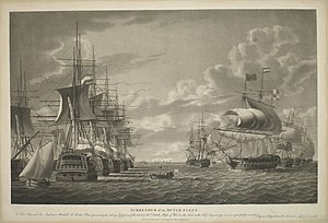
Vlieter incident
Dutch surrender during the War of the Second Coalition
Distance: Approx. 5528 meters
Latitude and longitude: 52.9,4.97
In the Vlieter incident on 30 August 1799, a squadron of the Batavian Navy, commanded by Rear-Admiral Samuel Story, surrendered to the British navy. The incident occurred during the Anglo-Russian invasion of Holland. It occurred in the tidal trench between Texel and the mainland that was known as De Vlieter, near Wieringen.

Den Oever Lighthouse
Lighthouse
Distance: Approx. 793 meters
Latitude and longitude: 52.93533333,5.04222222
The Den Oever Lighthouse is a cast iron lighthouse in Den Oever, the Netherlands, on the Wadden Sea. Erected in 1885, it was originally located at the western end of the former island of Wieringen where it served as the rear light of a pair of leading lights. In 1930, when the Afsluitdijk was finished, the tower was relocated to the eastern end of Wieringen at Den Oever.

De Hoop, Den Oever
Dutch windmill
Distance: Approx. 196 meters
Latitude and longitude: 52.934444,5.028333
De Hoop is a windmill in Den Oever, Netherlands. The mill was built in 1675 as a corn mill and served until the end of the 1930s. In 1952, the Oud-Wieringen De Hoop foundation purchased it in order to preserve it.
Weather in this IP's area
heavy intensity rain
8 Celsius
2 Celsius
7 Celsius
8 Celsius
996 hPa
87 %
996 hPa
996 hPa
10000 meters
17.49 m/s
22.64 m/s
200 degree
100 %