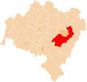
Country:
 Poland
Region:
City:
Latitude and Longitude:
Time Zone:
Postal Code:
IP information under different IP Channel
ip-api
Country
Region
City
ASN
Time Zone
ISP
Blacklist
Proxy
Latitude
Longitude
Postal
Route
IPinfo
Country
Region
City
ASN
Time Zone
ISP
Blacklist
Proxy
Latitude
Longitude
Postal
Route
MaxMind
Country
Region
City
ASN
Time Zone
ISP
Blacklist
Proxy
Latitude
Longitude
Postal
Route
Luminati
Country
PLRegion
02
City
wroclaw
ASN
Time Zone
Europe/Warsaw
ISP
Netia SA
Latitude
Longitude
Postal
db-ip
Country
Region
City
ASN
Time Zone
ISP
Blacklist
Proxy
Latitude
Longitude
Postal
Route
ipdata
Country
Region
City
ASN
Time Zone
ISP
Blacklist
Proxy
Latitude
Longitude
Postal
Route
Popular places and events near this IP address

Wrocław Voivodeship (1975–1998)
Distance: Approx. 3683 meters
Latitude and longitude: 51.116667,17.033333
Wrocław Voivodeship (Polish: województwo wrocławskie) was a voivodeship (province) of Poland that existed from 1975 until 31 December 1998, when it was absorbed into the larger Lower Silesian Voivodeship.
Wrocław County
County in Lower Silesian Voivodeship, Poland
Distance: Approx. 3683 meters
Latitude and longitude: 51.11666667,17.03333333
Wrocław County (Polish: powiat wrocławski) is a unit of territorial administration and local government (powiat) in Lower Silesian Voivodeship, south-western Poland. It came into being on January 1, 1999, as a result of the Polish local government reforms passed in 1998. The county covers an area of 1,116 square kilometres (431 sq mi).

Battle of Breslau (1757)
1757 battle during the Third Silesian War
Distance: Approx. 3679 meters
Latitude and longitude: 51.1167,17.0333
The Battle of Breslau (also known as the Battle on the Lohe) was fought on 22 November 1757 in Breslau (now Wrocław, Poland) during the Third Silesian War (part of the Seven Years' War). A Prussian army of 28,000 men fought an Austrian army of 60,000 men. The Prussians held off the Austrian attack, losing 6,000 men to the Austrians' 5,000 men.

Siege of Breslau
1945 siege of the German city of Breslau during World War II
Distance: Approx. 3683 meters
Latitude and longitude: 51.11666667,17.03333333
The siege of Breslau, also known as the Battle of Breslau, was a three-month-long siege of the city of Breslau in Lower Silesia, Germany (now Wrocław, Poland), lasting to the end of World War II in Europe. From 13 February 1945 to 6 May 1945, German troops in Breslau were besieged by the Soviet forces which encircled the city as part of the Lower Silesian Offensive Operation. The German garrison's surrender on 6 May was followed by the surrender of all German forces two days after the battle.

Wrocław Academy of Music
School
Distance: Approx. 3293 meters
Latitude and longitude: 51.111119,17.020931
The Karol Lipiński Academy of Music (Polish: Akademia Muzyczna im. Karola Lipińskiego, 'AMKL') is a university level school of music in Wrocław, Poland. It was established in November 1948 and is located on John Paul II Square.

Wrocław Stadium
Stadium in Poland
Distance: Approx. 3145 meters
Latitude and longitude: 51.14116667,16.94377778
The Wrocław Stadium (Polish: Stadion Wrocław), known for sponsorship reasons as the Tarczyński Arena Wrocław since 2021, is a UEFA Category Four association football stadium built for the 2012 UEFA European Football Championship. The Stadium is located on aleja Śląska (English: Silesian Avenue) in the district of Fabryczna, Wrocław. It is the home stadium of the Śląsk Wrocław football team playing in the Polish Ekstraklasa.

Hala Orbita
Distance: Approx. 228 meters
Latitude and longitude: 51.13247222,16.98724444
Hala Orbita is a multi-purpose Indoor arena in Wrocław, Poland. It hosts the home games of Śląsk Wrocław basketball club, Śląsk Wrocław handball club and Gwardia Wrocław men's and women's volleyball clubs. It has a seating capacity for 3,000 people.
Osobowice Cemetery
Cemetery in Wroclaw, Poland
Distance: Approx. 1853 meters
Latitude and longitude: 51.13583333,17.01083333
The Osobowice Cemetery (German: Friedhof Oswitz) is a large municipal cemetery in Wrocław (the capital of the Lower Silesian Voivodeship), Poland. It is located along Osobowicka 47-59 Street. It covers the area of 52 hectares (130 acres).
Siege of Breslau (1757)
1757 siege
Distance: Approx. 3679 meters
Latitude and longitude: 51.1167,17.0333
The siege of Breslau was a siege in the Third Silesian War (part of the Seven Years' War) that began on 7 December 1757 and ended on 19 December 1757. After the defeat at Leuthen, the Austrians withdrew into Breslau. The combined Austro-French garrison of approximately 17,000 men, commanded by Lieutenant General Field Marshal Soloman Sprecher von Bernegg, faced a Prussian army commanded by Frederick the Great.
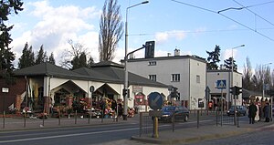
Wrocław Muchobór railway station
Railway station in Wrocław, Poland
Distance: Approx. 2362 meters
Latitude and longitude: 51.110556,16.975
Wrocław Muchobór is a railway station in Wrocław, at Traktowa Street in the Muchobór Mały housing estate located at the crossroads of the Wrocław-Szczecin and Wrocław-Guben lines. Only passenger trains towards Zielona Góra and Legnica stop at the station. It is an important railway junction where the freight ring road begins (from the north-western side).

Wrocław Contemporary Museum
Art museum in Wrocław, Poland
Distance: Approx. 2371 meters
Latitude and longitude: 51.11324,17.00503
Wrocław Contemporary Museum (Polish: Muzeum Współczene Wrocław; MWW), is a museum located in Wrocław, Poland. It was established in 2011. It develops relations with contemporary artists by exhibitions and educational events, while expanding its art collection.

John Paul II Square, Wrocław
Square in Wrocław, Poland
Distance: Approx. 3296 meters
Latitude and longitude: 51.11168,17.02176
The John Paul II Square (Polish: plac Jana Pawła II [plat͡s ˈjana ˈpavwa druˈɡʲɛɡɔ]) is a square and important transit point in Wrocław, Poland. The square is situated in the Szczepin district.
Weather in this IP's area
clear sky
29 Celsius
30 Celsius
28 Celsius
30 Celsius
1012 hPa
47 %
1012 hPa
999 hPa
10000 meters
8.23 m/s
130 degree
06:16:47
19:22:53