Country:
 Poland
Region:
City:
Latitude and Longitude:
Time Zone:
Postal Code:
IP information under different IP Channel
ip-api
Country
Region
City
ASN
Time Zone
ISP
Blacklist
Proxy
Latitude
Longitude
Postal
Route
IPinfo
Country
Region
City
ASN
Time Zone
ISP
Blacklist
Proxy
Latitude
Longitude
Postal
Route
MaxMind
Country
Region
City
ASN
Time Zone
ISP
Blacklist
Proxy
Latitude
Longitude
Postal
Route
Luminati
Country
PLRegion
02
City
wroclaw
ASN
Time Zone
Europe/Warsaw
ISP
Netia SA
Latitude
Longitude
Postal
db-ip
Country
Region
City
ASN
Time Zone
ISP
Blacklist
Proxy
Latitude
Longitude
Postal
Route
ipdata
Country
Region
City
ASN
Time Zone
ISP
Blacklist
Proxy
Latitude
Longitude
Postal
Route
Popular places and events near this IP address

Krzyki
Former borough in Wrocław, Poland
Distance: Approx. 1782 meters
Latitude and longitude: 51.08,17.05333333
Krzyki (Polish: [ˈkʂɨkʲi]; German: Krietern [ˈkʁiːtɐn]) is a former borough of Wrocław located in the southern part of the city. On March 21, 1991, the newly created City Office of Wrocław assumed many of the functions previously carried out within the borough. The name, though, remained in use, mainly for statistical and administrative purposes.
Wrocław University of Economics
Public university located in Wrocław, Poland
Distance: Approx. 587 meters
Latitude and longitude: 51.09138889,17.025
The Wroclaw University of Economics and Business (Uniwersytet Ekonomiczny we Wrocławiu) is one of ten public universities located in Wrocław, Poland. Originally established in 1947 as a private business school (then named Wyższa Szkoła Handlowa, or "Trade College"), it was nationalized in 1954 under the name Wyższa Szkoła Ekonomiczna ("College of Economics"). In October 1974 it was named after the Polish economist Oskar Lange, although his name does not occur in the official English name of the university.

Poltegor Centre
Distance: Approx. 1043 meters
Latitude and longitude: 51.09398056,17.019925
Poltegor Centre (formerly Poltegor) was the highest building in Wrocław. It was built in 1982 and the name originates from a mining company called Poltegor (an acronym for Polska Technika Górnicza, "Polish Mining Technics"). During the 1980s, the building was the company's headquarters, and even after that period they still occupied a fair part of the building.

Wrocław Water Tower
Water tower in Wrocław, Poland
Distance: Approx. 980 meters
Latitude and longitude: 51.08522222,17.01755556
The Wrocław Water Tower (Polish: Wieża ciśnień we Wrocławiu) is a historic water tower situated in the Borek neighbourhood of Wrocław, Poland.
BISC Wrocław
Independent school in Wrocław, Dolnośląskie, Poland
Distance: Approx. 1177 meters
Latitude and longitude: 51.083294,17.015694
British International School of Wrocław (BISC Wrocław) is a co-educational private school in Wrocław, Poland. The school opened in September 2006 to provide primary and secondary educations for the growing expatriate community. BISC Wroclaw is the sister school of the British International School of Cracow (BISC).
Wrocław Główny railway station
Railway station in Wrocław, Poland
Distance: Approx. 1294 meters
Latitude and longitude: 51.0988,17.0365
Wrocław Główny is the largest and most important passenger train station in the city of Wrocław, in southwestern Poland. Situated at the junction of several important routes, it is the largest railway station in the Lower Silesia Voivodeship, as well as in Poland in terms of the number of passengers serviced. In 2018, the station served over 21.2 million passengers.

Sky Tower (Wrocław)
Skyscraper in Wrocław, Poland
Distance: Approx. 1169 meters
Latitude and longitude: 51.09388889,17.0175
Sky Tower is a skyscraper in Wrocław, Poland. At 212 metres (696 ft) and featuring 51 floors, it is the tallest building in Wrocław and was also the tallest building in Poland in the category of height to roof until Varso Tower overtook it in 2022. Construction began in 2007 and was completed in 2012.

Wrocław Polish Theatre
Distance: Approx. 1540 meters
Latitude and longitude: 51.101226,17.026352
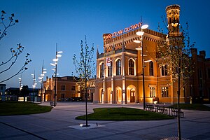
The Polish Theatre in Wrocław (Polish: Teatr Polski we Wrocławiu) is one of the theatres in Wrocław, Poland. The Polish Theatre in Wrocław has three stages: Small Stage on 28 Świdnicka Street, “Na Świebodzkim” Stage, situated inside Świebodzki railway station's building at 20c Orląt Lwowskich Square, and Jerzy Grzegorzewski Stage located in the Theatre's main building at 3 Zapolska Street. The main building, the result of the endeavors of a Wrocław merchant: Paul Auerbach, was designed by Berlin architect: Walter Hentschel and completed in 1909.

Old Jewish Cemetery, Wrocław
Cemetery in Wrocław, Poland
Distance: Approx. 435 meters
Latitude and longitude: 51.08666667,17.025
The Old Jewish Cemetery (Polish: Stary Cmentarz Żydowski we Wrocławiu) is a historic necropolis-museum situated on 37/39 Ślężna Street, in the southern part of Wrocław (formerly Breslau), Poland. Opened in 1856, the cemetery's eclectic layout features many architectural forms and styles on a monumental scale. The current shape of the cemetery evolved mostly throughout the 19th century, during the times of the German Empire.

Cupid on the Pegasus
Sculpture in Wrocław, Poland
Distance: Approx. 1872 meters
Latitude and longitude: 51.10431,17.03517
The Cupid on the Pegasus monument (Polish: Pomnik Amora na Pegazie, German: Amor auf dem Pegasus reitend) in Wrocław, Poland, is a monument located in Nicolaus Copernicus Park (Park Mikołaja Kopernika we Wrocławiu), within the Old Town Promenade at Teatralna Street. The sculptor was Theodor von Gosen.
Powstańców Śląskich
District in Wrocław, Poland
Distance: Approx. 977 meters
Latitude and longitude: 51.09333333,17.02027778
Powstańców Śląskich (Polish: [pɔfˈstaj̃t͡suf ˈɕlɔ̃skʲix], lit. '[district] of Silesian Insurgents'; German: Neudorf [ˈnɔʏdɔʁf]), also sometimes referred to as Południe (Polish: [pɔˈwudɲɛ] ), is a district in Wrocław located in the southern part of the city. It was established in the territory of the former Krzyki district. Originally a village, the settlement was incorporated into Breslau (Wrocław) in 1868.

Silesian Insurgents Square
Square in Wrocław, Poland
Distance: Approx. 1056 meters
Latitude and longitude: 51.090221,17.01644
The Silesian Insurgents Square (Polish: plac Powstańców Śląskich [ˈplat͡s pɔfˈstaj̃t͡suf ˈɕlɔ̃skʲix]), commonly and colloquially referred to as Rondo (Polish: [ˈrɔndɔ], 'The Roundabout'), is a circular square and important transit point in Wrocław, Poland. The roundabout is situated in the Powstańców Śląskich district and measures approximately 220 meters in diameter. It comprises a three-lane roadway and a green, tree-lined area in the center.
Weather in this IP's area
clear sky
29 Celsius
29 Celsius
28 Celsius
30 Celsius
1012 hPa
46 %
1012 hPa
998 hPa
10000 meters
8.23 m/s
130 degree
06:16:39
19:22:40