Country:
 Great Britain
Region:
City:
Latitude and Longitude:
Time Zone:
Postal Code:
IP information under different IP Channel
ip-api
Country
Region
City
ASN
Time Zone
ISP
Blacklist
Proxy
Latitude
Longitude
Postal
Route
IPinfo
Country
Region
City
ASN
Time Zone
ISP
Blacklist
Proxy
Latitude
Longitude
Postal
Route
MaxMind
Country
Region
City
ASN
Time Zone
ISP
Blacklist
Proxy
Latitude
Longitude
Postal
Route
Luminati
Country
GBRegion
eng
City
durham
ASN
Time Zone
Europe/London
ISP
TalkTalk
Latitude
Longitude
Postal
db-ip
Country
Region
City
ASN
Time Zone
ISP
Blacklist
Proxy
Latitude
Longitude
Postal
Route
ipdata
Country
Region
City
ASN
Time Zone
ISP
Blacklist
Proxy
Latitude
Longitude
Postal
Route
Popular places and events near this IP address

Ushaw College
Church in Durham, UK
Distance: Approx. 2080 meters
Latitude and longitude: 54.78818,-1.66116
Ushaw College (formally St Cuthbert's College, Ushaw) is a former Catholic seminary near the village of Ushaw Moor, County Durham, England, which is now a heritage and cultural tourist attraction. The college is known for its Georgian and Victorian Gothic architecture and listed nineteenth-century chapels. The college now hosts a programme of art exhibitions, music and theatre events, alongside tearooms and a café.

Bearpark
Village and civil parish in County Durham, England
Distance: Approx. 324 meters
Latitude and longitude: 54.782222,-1.63
Bearpark is a village and civil parish in County Durham in England. It is situated two and a half miles west of Durham, and a short distance to the north of Ushaw Moor. The name may be a corruption of the French term Beau Repaire – meaning "beautiful retreat".
Broompark
Human settlement in England
Distance: Approx. 1752 meters
Latitude and longitude: 54.7698,-1.6228
Broompark is a village in County Durham, England. It is situated some 3 miles (4.8 km) west of Durham city. It was once the site of the Broompark colliery, operated by North Brancepeth Coal company.

New Brancepeth
Distance: Approx. 2448 meters
Latitude and longitude: 54.76666667,-1.65
New Brancepeth is a village in County Durham, in England. It is about 3 miles (5 km) west of the centre of Durham, above the River Deerness. Its population is around 100–200.
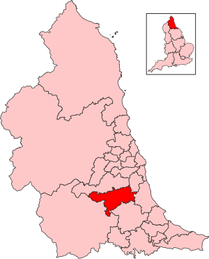
City of Durham (UK Parliament constituency)
Parliamentary constituency in the United Kingdom, 1678 onwards
Distance: Approx. 2084 meters
Latitude and longitude: 54.77,-1.61
City of Durham is a constituency represented in the House of Commons of the UK Parliament since 2019 by Mary Kelly Foy of the Labour Party.

New College Durham
College in Durham, UK
Distance: Approx. 2508 meters
Latitude and longitude: 54.796,-1.595
New College Durham is a further and higher education college and a sixth form college in County Durham, England. It was founded in 1977 as a result of a merger between Neville's Cross College of Education and Durham Technical College. It holds foundation degree awarding powers.
Durham Johnston Comprehensive School
Community comprehensive school in Crossgate Moor Durham, County Durham, England
Distance: Approx. 2204 meters
Latitude and longitude: 54.77948,-1.59628
Durham Johnston Comprehensive School is a secondary school in Durham, England.

Aldin Grange for Bearpark railway station
Disused railway station in Bearpark, County Durham
Distance: Approx. 629 meters
Latitude and longitude: 54.782,-1.621
Aldin Grange for Bearpark railway station was located on the Lanchester Valley Railway that operated in County Durham, England. The railway station opened in 1883 as Aldin Grange, and was renamed Aldin Grange for Bearpark about a year later. In 1927 its name was changed to Bearpark.

Ushaw Moor
Village in England
Distance: Approx. 1320 meters
Latitude and longitude: 54.778,-1.64565867
Ushaw Moor is an old pit village in County Durham, in England, on the north side of the River Deerness. It is situated to the west of Durham, a short distance to the south of Bearpark. Ushaw Moor falls within the Deerness electoral ward in the City of Durham constituency, whose MP since 2019 has been Mary Foy.
Ushaw Moor railway station
Former railway station in England
Distance: Approx. 1727 meters
Latitude and longitude: 54.774,-1.648
Ushaw Moor railway station, was a station on the Deerness Valley Railway, south of the village of Ushaw Moor in County Durham, was opened on 1 September 1884 by the North Eastern Railway. The station closed to passengers on 29 October 1951 and freight on 28 December 1964. The stone and timber built station was demolished and few traces of it remain.
Durham Academy, Ushaw Moor
Academy in Ushaw Moor, County Durham, England
Distance: Approx. 676 meters
Latitude and longitude: 54.7816,-1.6378
Durham Academy (formerly Durham Community Business College) is a coeducational secondary school located in Ushaw Moor, County Durham, England. The school educates pupils from Ushaw Moor and surrounding villages, including Sacriston, Lanchester, Esh Winning, Witton Gilbert, Langley Park and other areas North of Durham.

University Hospital of North Durham
Hospital in Durham, England
Distance: Approx. 2346 meters
Latitude and longitude: 54.7893,-1.59339
University Hospital of North Durham is an acute care hospital built to replace the older Dryburn Hospital on the same site. It is managed by the County Durham and Darlington NHS Foundation Trust.
Weather in this IP's area
overcast clouds
14 Celsius
14 Celsius
14 Celsius
15 Celsius
1006 hPa
94 %
1006 hPa
991 hPa
2418 meters
1.76 m/s
3.12 m/s
5 degree
100 %
06:26:54
19:41:39