Country:
 Czech Republic
Region:
City:
Latitude and Longitude:
Time Zone:
Postal Code:
IP information under different IP Channel
ip-api
Country
Region
City
ASN
Time Zone
ISP
Blacklist
Proxy
Latitude
Longitude
Postal
Route
IPinfo
Country
Region
City
ASN
Time Zone
ISP
Blacklist
Proxy
Latitude
Longitude
Postal
Route
MaxMind
Country
Region
City
ASN
Time Zone
ISP
Blacklist
Proxy
Latitude
Longitude
Postal
Route
Luminati
Country
CZRegion
32
City
pilsen
ASN
Time Zone
Europe/Prague
ISP
Quantcom, a.s.
Latitude
Longitude
Postal
db-ip
Country
Region
City
ASN
Time Zone
ISP
Blacklist
Proxy
Latitude
Longitude
Postal
Route
ipdata
Country
Region
City
ASN
Time Zone
ISP
Blacklist
Proxy
Latitude
Longitude
Postal
Route
Popular places and events near this IP address

Úhlava
River in Plzeň, Czech Republic
Distance: Approx. 6067 meters
Latitude and longitude: 49.72055556,13.38861111
The Úhlava (German: Angel) is a river in the Czech Republic, a right tributary of the Radbuza River. It flows through the Plzeň Region to the city of Plzeň. It is 104.0 km (64.6 mi) long, making it the 19th longest river in the Czech Republic.

University of West Bohemia
Distance: Approx. 3998 meters
Latitude and longitude: 49.72368889,13.35154167
The University of West Bohemia (Czech: Západočeská univerzita v Plzni, ZČU) is a university in Plzeň, Czech Republic. It was founded in 1991 and consists of nine faculties.
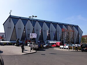
Logspeed CZ Aréna
Distance: Approx. 6352 meters
Latitude and longitude: 49.73666667,13.3775
LOGSPEED CZ Aréna is an indoor sporting arena located in Plzeň, Czech Republic. The capacity of the arena is 7,356 people. The ice rink was established in 1950 as an open-air stadium, and between 1966 and 1970 the area was developed to cover the playing surface.

Dobřany
Town in Plzeň, Czech Republic
Distance: Approx. 5243 meters
Latitude and longitude: 49.65388889,13.29027778
Dobřany (Czech pronunciation: [ˈdobr̝anɪ]; German: Dobrzan) is a town in Plzeň-South District in the Plzeň Region of the Czech Republic. It has about 6,400 inhabitants. The historic town centre is well preserved and is protected by law as urban monument zone.

Zbůch
Municipality in Plzeň, Czech Republic
Distance: Approx. 6553 meters
Latitude and longitude: 49.67861111,13.22583333
Zbůch (German: Zwug) is a municipality and village in Plzeň-North District in the Plzeň Region of the Czech Republic. It has about 3,000 inhabitants.

Nová Ves (Plzeň-South District)
Municipality in Plzeň, Czech Republic
Distance: Approx. 1954 meters
Latitude and longitude: 49.68611111,13.29277778
Nová Ves is a municipality and village in Plzeň-South District in the Plzeň Region of the Czech Republic. It has about 300 inhabitants. Nová Ves lies approximately 10 kilometres (6 mi) south-west of Plzeň and 93 km (58 mi) south-west of Prague.

Útušice
Municipality in Plzeň, Czech Republic
Distance: Approx. 5634 meters
Latitude and longitude: 49.67777778,13.38222222
Útušice is a municipality and village in Plzeň-South District in the Plzeň Region of the Czech Republic. It has about 700 inhabitants. Útušice lies approximately 8 kilometres (5 mi) south of Plzeň and 88 km (55 mi) south-west of Prague.

Líně
Municipality in Plzeň, Czech Republic
Distance: Approx. 3955 meters
Latitude and longitude: 49.69472222,13.25666667
Líně is a municipality and village in Plzeň-North District in the Plzeň Region of the Czech Republic. It has about 2,900 inhabitants.

Tlučná
Municipality in Plzeň, Czech Republic
Distance: Approx. 6141 meters
Latitude and longitude: 49.72416667,13.23527778
Tlučná is a municipality and village in Plzeň-North District in the Plzeň Region of the Czech Republic. It has about 3,400 inhabitants.

Vejprnice
Municipality in Plzeň, Czech Republic
Distance: Approx. 4240 meters
Latitude and longitude: 49.72972222,13.27638889
Vejprnice is a municipality and village in Plzeň-North District in the Plzeň Region of the Czech Republic. It has about 4,600 inhabitants.
Modrá Hvězda Dobřany
Czech independent beer brewery
Distance: Approx. 5083 meters
Latitude and longitude: 49.6554275,13.2900819
Modrá Hvězda Dobřany is a small, independent Czech beer brewery based in the town of Dobřany. Beer has been brewed in Dobřany since 1378. Modrá Hvězda opened in 1998, founded by Jaroslav Franěk, who had previously worked at Pilsner Urquell.

Techmania Science Center
Czech science center
Distance: Approx. 5904 meters
Latitude and longitude: 49.7409,13.3615
Techmania Science Center is one of the first science centers in the Czech Republic and an institution of informal education. The project was established in 2005 by the Škoda Transportation joint-stock company and the University of West Bohemia in Pilsen. The intention has been to build up a modern, interactive center (often known as a science center) in the industrial estate of the Škoda company.
Weather in this IP's area
overcast clouds
14 Celsius
13 Celsius
13 Celsius
16 Celsius
1014 hPa
84 %
1014 hPa
973 hPa
10000 meters
2.24 m/s
130 degree
100 %
07:33:10
18:10:12