Country:
 Belgium
Region:
City:
Latitude and Longitude:
Time Zone:
Postal Code:
IP information under different IP Channel
ip-api
Country
Region
City
ASN
Time Zone
ISP
Blacklist
Proxy
Latitude
Longitude
Postal
Route
IPinfo
Country
Region
City
ASN
Time Zone
ISP
Blacklist
Proxy
Latitude
Longitude
Postal
Route
MaxMind
Country
Region
City
ASN
Time Zone
ISP
Blacklist
Proxy
Latitude
Longitude
Postal
Route
Luminati
Country
BERegion
vlg
City
bruges
ASN
Time Zone
Europe/Brussels
ISP
DC STAR nv
Latitude
Longitude
Postal
db-ip
Country
Region
City
ASN
Time Zone
ISP
Blacklist
Proxy
Latitude
Longitude
Postal
Route
ipdata
Country
Region
City
ASN
Time Zone
ISP
Blacklist
Proxy
Latitude
Longitude
Postal
Route
Popular places and events near this IP address

St. Salvator's Cathedral
Distance: Approx. 472 meters
Latitude and longitude: 51.2055,3.2215
St. Salvator's Cathedral (Dutch: Sint-Salvatorskathedraal), also known as the Cathedral of the Saviour and St. Donat, is the Roman Catholic cathedral of Bruges, Belgium.
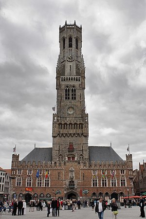
Belfry of Bruges
UNESCO World Heritage Site in Bruges, Belgium
Distance: Approx. 447 meters
Latitude and longitude: 51.20833333,3.22472222
The Belfry of Bruges (Dutch: Belfort van Brugge) is a medieval bell tower in the centre of Bruges, Belgium. One of the city's most prominent symbols, the belfry formerly housed a treasury and the municipal archives and served as an observation post for spotting fires and other dangers.

Markt, Bruges
Square in Bruges, Belgium
Distance: Approx. 428 meters
Latitude and longitude: 51.20833333,3.22444444
The Markt (Dutch for "Market") is the central square of Bruges, West Flanders, Belgium. It is located in the city centre and covers an area of about 1 ha (2.5 acres). On the south side of the square is one of the city's most famous landmarks, the 12th-century Belfry.

Huis 't Schaep
Distance: Approx. 497 meters
Latitude and longitude: 51.204932,3.21996
Huis 't Schaep is the name of two 17th century dwellings, which have been converted into one house at Korte Vuldersstraat 14, 8000 Bruges, Belgium. The buildings had a step gable each, but have been remodelled in the Gothic Revival Style during the conversion by Samuel Coucke. It was the house and workshop of the Coucke family, who made stained glass windows.
Choco-Story Brugge
Distance: Approx. 549 meters
Latitude and longitude: 51.21055556,3.22611111
Choco-Story, the Chocolate Museum in Bruges, Belgium, is located in the sixteenth-century "Huis de Crone" building on Sint-Jansplein (at the intersection of Wijnzakstraat and Sint-Jansstraat) in central Bruges. This building was originally the home of a wine tavern. It later housed a bakery and, most recently, a furniture making shop.

Frietmuseum
Food museum in Bruges, Belgium
Distance: Approx. 426 meters
Latitude and longitude: 51.21111111,3.22388889
The Frietmuseum (Fries museum) is a museum in Bruges, Belgium, which is devoted to the history of potatoes and the production of Belgian fries. It describes itself as "the first and only museum dedicated to potato fries".

Bruges
Capital of West Flanders province, Belgium
Distance: Approx. 398 meters
Latitude and longitude: 51.20888889,3.22416667
Bruges ( BROOZH, French: [bʁyʒ] ; Dutch: Brugge [ˈbrʏɣə] ; West Flemish: Brugge [ˈbrœɦə]; ‹See Tfd›German: Brügge [ˈbʁʏɡə] ) is the capital and largest city of the province of West Flanders in the Flemish Region of Belgium, in the northwest of the country. It is the sixth most populous city in the country. The area of the whole city amounts to more than 14,099 hectares (140.99 km2; 54.44 sq miles), including 1,075 hectares off the coast, at Zeebrugge (from Brugge aan zee, meaning 'Bruges by the Sea').

Cranenburg House
Building in Bruges, Belgium
Distance: Approx. 366 meters
Latitude and longitude: 51.20862,3.22364
The Cranenburg House (also Craenenburg) is a historic building located on the Markt (main square) of Bruges, Belgium. The building is now a café with a historicised facade by M. Vermeersch from 1956. George W. T. Omond's Bruges and West Flanders (1906), illustrated by Amédée Forestier, refers to the building: Cranenburg, from the windows of which, in olden times, the Counts of Flanders, with the lords and ladies of their Court, used to watch the tournaments and pageants for which Bruges was celebrated, and in which Maximilian was imprisoned by the burghers in 1488.

Provinciaal Hof
Building in Bruges, Belgium
Distance: Approx. 469 meters
Latitude and longitude: 51.2089,3.2252
The Provinciaal Hof (English: Provincial Court) is a neo-Gothic building on the Markt (main square) in Bruges, Belgium. It is the former meeting place for the Provincial Government of West Flanders.

St. James's Church, Bruges
Distance: Approx. 211 meters
Latitude and longitude: 51.2106,3.2207
St. James's Church (Sint-Jakobskerk) is a Catholic church in Bruges, Belgium. Originally built around 1240, the church was considerably expanded in 1459 to match the rising affluence of Bruges, and was patronized by the Duke of Burgundy.

Provostry of St. Donatian
Distance: Approx. 539 meters
Latitude and longitude: 51.20867,3.22616
The Provostry of St. Donatian (Dutch: Sint-Donaasproosdij or Proosdij van de kerkelijke heerlijkheid van Sint-Donaas) is a Baroque building on the Burg Square in Bruges, Belgium. Built in the 17th century, it served as the headquarters of the ecclesiastical seigniory of St.
Bruges Public Library
Distance: Approx. 307 meters
Latitude and longitude: 51.2099,3.2228
The Bruges Public Library is a public library in Bruges, Belgium. Since its foundation in 1796 the Public Library of Bruges has functioned both as a public library and a special collections library. The core of the special collections consists of ca.
Weather in this IP's area
light rain
12 Celsius
12 Celsius
12 Celsius
14 Celsius
1005 hPa
88 %
1005 hPa
1004 hPa
10000 meters
10.91 m/s
15.79 m/s
252 degree
100 %
07:47:59
19:25:14