81.93.206.224 - IP Lookup: Free IP Address Lookup, Postal Code Lookup, IP Location Lookup, IP ASN, Public IP
Country:
Region:
City:
Location:
Time Zone:
Postal Code:
IP information under different IP Channel
ip-api
Country
Region
City
ASN
Time Zone
ISP
Blacklist
Proxy
Latitude
Longitude
Postal
Route
Luminati
Country
Region
fe
City
szekesfehervar
ASN
Time Zone
Europe/Budapest
ISP
Datatrans Internet Ltd
Latitude
Longitude
Postal
IPinfo
Country
Region
City
ASN
Time Zone
ISP
Blacklist
Proxy
Latitude
Longitude
Postal
Route
IP2Location
81.93.206.224Country
Region
komarom-esztergom
City
tatabanya
Time Zone
Europe/Budapest
ISP
Language
User-Agent
Latitude
Longitude
Postal
db-ip
Country
Region
City
ASN
Time Zone
ISP
Blacklist
Proxy
Latitude
Longitude
Postal
Route
ipdata
Country
Region
City
ASN
Time Zone
ISP
Blacklist
Proxy
Latitude
Longitude
Postal
Route
Popular places and events near this IP address

Komárom-Esztergom County
County of Hungary
Distance: Approx. 4499 meters
Latitude and longitude: 47.58333333,18.33333333
Komárom-Esztergom (Hungarian: Komárom-Esztergom vármegye, pronounced [ˈkomaːrom ˈɛstɛrɡom]; German: Komitat Komorn-Gran; Slovak: Komárňansko-ostrihomská župa) is an administrative Hungarian county in Central Transdanubia Region; its shares its northern border the Danube with Slovakia. It shares borders with the Hungarian counties of Győr-Moson-Sopron, Veszprém, Fejér and Pest and the Slovakian Nitra Region (Nové Zámky District, Komárno District). Its county seat is Tatabánya.

Tatabánya
City with county rights in Central Transdanubia, Hungary
Distance: Approx. 187 meters
Latitude and longitude: 47.58616,18.39485
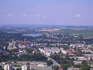
Tatabánya (Hungarian: [ˈtɒtɒbaːɲɒ] ; German: Totiserkolonie; Slovak: Banská Stará) is a city with county rights of 64,305 inhabitants in northwestern Hungary, in the Central Transdanubian region. It is the capital of Komárom-Esztergom County.

Környe
Place in Komárom-Esztergom, Hungary
Distance: Approx. 6644 meters
Latitude and longitude: 47.54534,18.32697
Környe (German: Kirne) is a village in Komárom-Esztergom county, Hungary.
Vértesszőlős
Place in Komárom-Esztergom, Hungary
Distance: Approx. 3900 meters
Latitude and longitude: 47.61884,18.3803
Vértesszőlős is a village in Komárom-Esztergom county, Hungary. It is most known for the archaeological site where a Middle Pleistocene human fossil, known as "Samu", was found.

Vértestolna
Place in Komárom-Esztergom, Hungary
Distance: Approx. 6780 meters
Latitude and longitude: 47.62839,18.45644
Vértestolna (German: Tolnau) is a village in Komárom-Esztergom county, Hungary.
Samu (fossil)
Hominin fossil
Distance: Approx. 4737 meters
Latitude and longitude: 47.627,18.384
Samu (VSZ II) is the nickname given to a fragmentary Middle Pleistocene human occipital, also known as Vertesszolos Man or Vertesszolos occipital, discovered in Vértesszőlős, Central Transdanubia, Hungary.

Szelim cave
Cave and archaeological site in Hungary
Distance: Approx. 1193 meters
Latitude and longitude: 47.59027778,18.40694444
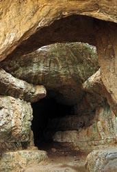
The Szelim cave (Hungarian: Szelim-barlang or Szelim-lyuk (Szelim hole), Bánhidai nagy barlang (Bánhidian big cave), Eperjes-barlang, Szemi-luki, Szemi-lyuka, Szelimluk barlang, Bánhidai-zsomboly, Szent Vit-barlang) is located in northwestern Hungary at the western margin of the Gerecse Mountains, 289 m (948 ft) above the Által-ér Valley near Tatabánya city. The cave interior is 45 m (148 ft) long and 14 m (46 ft) high. The site has been regularly frequented and used as a shelter by local villagers over the centuries, is easily accessible and its huge rectangular entrance features a memorial of the Turul.

Gerecse Mountains
Mountain range in Hungary
Distance: Approx. 6565 meters
Latitude and longitude: 47.64333333,18.405
Gerecse is a mountain range in northwestern Hungary that belongs to the Transdanubian Mountains.

Bánhida
Distance: Approx. 1625 meters
Latitude and longitude: 47.57111111,18.38611111
Bánhida (in German: Weinhild) is the oldest quarter of the city of Tatabánya in north-western Hungary. Inhabited since ancient times, excavations in this area have uncovered finds from the Bronze Age and the Roman era. It is hypothesized that the name derives from a former landowner named Bán who owned a bridge across the Rákos River (now called Által-ér).

Imre Földi Sports Hall
Multi-use indoor arena in Tatabánya, Hungary
Distance: Approx. 3523 meters
Latitude and longitude: 47.5575,18.41666667
The Imre Földi Sports Hall (Hungarian: Földi Imre Sportcsarnok) is a multi-use indoor arena in Tatabánya, Hungary. The home of Hungarian top division handball club Tatabánya KC, it can accommodate up to 1,000 spectators in handball matches. Due to its dimensions, the sports hall is suitable for a number of other indoor sports as well as exhibitions and concerts.

Tatabánya railway station
Railway station in Tatabánya, Hungary
Distance: Approx. 74 meters
Latitude and longitude: 47.58555556,18.39333333
Tatabánya railway station (Hungarian: Tatabánya vasútállomás) is a railway station in Tatabánya, Komárom-Esztergom County, Hungary. The station opened on 15 July 1884. The station is located on the main line between Vienna and Budapest (Line 1 Budapest–Hegyeshalom railway), Line 12 Tatabánya–Oroszlány railway and Line 13 Tatabánya–Pápa railway.

Tatabánya District
Districts of Hungary in Komárom-Esztergom
Distance: Approx. 541 meters
Latitude and longitude: 47.5833,18.4
Tatabánya (Hungarian: Tatabányai járás; German: Kreis Totiserkolonie) is a district in south-eastern part of Komárom-Esztergom County. Tatabánya is also the name of the town where the district seat is found. The district is located in the Central Transdanubia Statistical Region.
Weather in this IP's area
overcast clouds
2 Celsius
-3 Celsius
2 Celsius
2 Celsius
1020 hPa
77 %
1020 hPa
993 hPa
10000 meters
7.28 m/s
14.91 m/s
329 degree
87 %
