81.92.85.18 - IP Lookup: Free IP Address Lookup, Postal Code Lookup, IP Location Lookup, IP ASN, Public IP
Country:
 France
Region:
City:
Location:
Time Zone:
Postal Code:
ISP:
ASN:
language:
User-Agent:
Proxy IP:
Blacklist:
IP information under different IP Channel
ip-api
Country
Region
City
ASN
Time Zone
ISP
Blacklist
Proxy
Latitude
Longitude
Postal
Route
db-ip
Country
Region
City
ASN
Time Zone
ISP
Blacklist
Proxy
Latitude
Longitude
Postal
Route
IPinfo
Country
Region
City
ASN
Time Zone
ISP
Blacklist
Proxy
Latitude
Longitude
Postal
Route
IP2Location
81.92.85.18Country
frRegion
pays-de-la-loire
City
angers
Time Zone
Europe/Paris
ISP
Language
User-Agent
Latitude
Longitude
Postal
ipdata
Country
Region
City
ASN
Time Zone
ISP
Blacklist
Proxy
Latitude
Longitude
Postal
Route
Popular places and events near this IP address

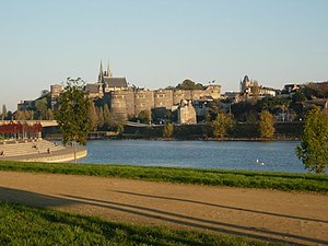
Château d'Angers
Castle in Angers, Maine-et-Loire, France
Distance: Approx. 856 meters
Latitude and longitude: 47.47,-0.56
The Château d'Angers is a castle in the city of Angers in the Loire Valley, in the département of Maine-et-Loire, in France. Founded in the 9th century by the Counts of Anjou, it was expanded to its current size in the 13th century. It is located overhanging the River Maine.

Angers
Prefecture and commune in Pays de la Loire, France
Distance: Approx. 847 meters
Latitude and longitude: 47.473612,-0.554167
Angers (French: [ɑ̃ʒe] , UK: , US: ;) is a city in western France, about 300 km (190 mi) southwest of Paris. It is the prefecture of the Maine-et-Loire department and was the capital of the province of Anjou until the French Revolution. The inhabitants of both the city and the province are called Angevins or, more rarely, Angeriens.

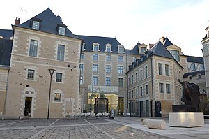
Catholic University of the West
Private French university
Distance: Approx. 227 meters
Latitude and longitude: 47.46472222,-0.54861111
The Catholic University of the West (French: Université catholique de l'Ouest), also known as UCO or colloquially as la Catho, is a private university located in Angers, France.

Angers Cathedral
Roman Catholic church in Angers, France
Distance: Approx. 589 meters
Latitude and longitude: 47.47055556,-0.555
Angers Cathedral (French: Cathédrale Saint-Maurice d'Angers) is a Catholic church dedicated to Saint Maurice in Angers, France. It is the seat of the Bishops of Angers. Built between the 11th and 16th centuries, it is known for its mixture of Romanesque and Gothic architecture, its ornate Baroque altar and sculpture.

Muséum d'histoire naturelle d'Angers
Municipal museum in Angers, France
Distance: Approx. 822 meters
Latitude and longitude: 47.47361111,-0.54638889
The Muséum des sciences naturelles d'Angers (commonly called Muséum d'Angers, as opposed to the arts museums, called Musées d'Angers) is a municipal museum in Angers (Maine-et-Loire, France). Dedicated to Natural History, the Muséum d'Angers houses in its collections about 530,000 objects, including 3,000 birds, 20,000 shells, 50,000 fossils, 80,000 insects and 350,000 herbarium samples, as well as hundreds of specimens taxidermised or in liquid, skeletons, minerals, technical instruments and Documents. The Muséum d'Angers receives annually about 20,000 visitors, as well as school groups, interns, researchers and volunteers.
Siege of Angers
1793 siege
Distance: Approx. 847 meters
Latitude and longitude: 47.4736,-0.5542
The siege of Angers was a siege of the French town of Angers on 3 December 1793 in the War in the Vendée. Among the combatants was Françoise Després, a loyal monarchist and Catholic who disguised herself as a man to serve in the Bourbon army.

Angers-Saint-Laud station
Railway station in France
Distance: Approx. 577 meters
Latitude and longitude: 47.46472222,-0.55694444
Angers-Saint-Laud is a railway station located in Angers, Maine-et-Loire, western France. The station was opened in 1849 and is located on the Le Mans–Angers railway and the Tours–Saint-Nazaire railway. The train services are operated by SNCF. The station is at 40 m above sea level and at kilometre post 342.950 of the Tours–Saint-Nazaire railway.

Apocalypse Tapestry
Tapestry woven in Paris, 1377 to 1382
Distance: Approx. 856 meters
Latitude and longitude: 47.47,-0.56
The Apocalypse Tapestry is a large medieval set of tapestries commissioned by Louis I, the Duke of Anjou, and woven in Paris between 1377 and 1382. It depicts the story of the Apocalypse from the Book of Revelation by Saint John the Divine in colourful images, spread over six tapestries that originally totalled 90 scenes, and were about six metres high, and 140 metres long in total. It is the most significant, and almost the only, survival from the first decades of the great period of tapestry, when the industry developed large workshops and represented the most effective art form for exhibiting the magnificence of royal patrons, not least because large tapestries were hugely expensive.
Musée des Beaux-Arts d'Angers
Art gallery and museum in Angers, France
Distance: Approx. 450 meters
Latitude and longitude: 47.46889,-0.55472
The Musée des beaux-arts d'Angers is a museum of art located in a mansion, the "logis Barrault", place Saint-Éloi near the historic city of Angers, western France.

Canton of Angers-1
Canton in Pays de la Loire, France
Distance: Approx. 379 meters
Latitude and longitude: 47.47,-0.55
The canton of Angers-1 (French: Canton d'Angers-1) is an administrative division of the Maine-et-Loire department, in western France. It was created at the French canton reorganisation which came into effect in March 2015. Its seat is in Angers.

Abbey of Saint-Aubin
Abbey in Angers
Distance: Approx. 352 meters
Latitude and longitude: 47.4687,-0.5533
Saint-Aubin Abbey is a former abbey in Angers, founded in the 6th century and dispersed during the French Revolution.

Hôtel de Ville, Angers
Town hall in Angers, France
Distance: Approx. 515 meters
Latitude and longitude: 47.4711,-0.5482
The Hôtel de Ville (French pronunciation: [otɛl də vil], City Hall) is a municipal building in Angers, Maine-et-Loire, west France, standing on the Boulevard Résistance et Déportation. It has been included on the Inventaire général des monuments by the French Ministry of Culture since 1981.
Weather in this IP's area
overcast clouds
7 Celsius
5 Celsius
7 Celsius
7 Celsius
1017 hPa
77 %
1017 hPa
1011 hPa
10000 meters
3.36 m/s
6.52 m/s
96 degree
100 %