81.9.250.234 - IP Lookup: Free IP Address Lookup, Postal Code Lookup, IP Location Lookup, IP ASN, Public IP
Country:
Region:
City:
Location:
Time Zone:
Postal Code:
ISP:
ASN:
language:
User-Agent:
Proxy IP:
Blacklist:
IP information under different IP Channel
ip-api
Country
Region
City
ASN
Time Zone
ISP
Blacklist
Proxy
Latitude
Longitude
Postal
Route
db-ip
Country
Region
City
ASN
Time Zone
ISP
Blacklist
Proxy
Latitude
Longitude
Postal
Route
IPinfo
Country
Region
City
ASN
Time Zone
ISP
Blacklist
Proxy
Latitude
Longitude
Postal
Route
IP2Location
81.9.250.234Country
Region
valenciana, comunidad
City
gandia
Time Zone
Europe/Madrid
ISP
Language
User-Agent
Latitude
Longitude
Postal
ipdata
Country
Region
City
ASN
Time Zone
ISP
Blacklist
Proxy
Latitude
Longitude
Postal
Route
Popular places and events near this IP address
Gandia
Municipality in Valencian Community, Spain
Distance: Approx. 58 meters
Latitude and longitude: 38.96666667,-0.18333333
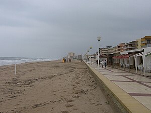
Gandia (Valencian: [ɡanˈdi.a], Spanish: Gandía [ɡanˈdi.a]) is a city and municipality in the Valencian Community, eastern Spain on the Mediterranean. Gandia is located on the Costa de Valencia, 65 kilometres (40 mi) south of Valencia and 110 km (68 mi) north of Alicante. Vehicles can access the city through road N-332 and AP-7 highway Gandia operated as an important cultural and commercial centre in the 15th and 16th centuries: in the 15th century it had a university.

Safor
Comarca in Valencian Community, Spain
Distance: Approx. 2784 meters
Latitude and longitude: 38.9756,-0.214061
Safor (Valencian: [saˈfoɾ]; Spanish: [saˈfoɾ]) is a comarca within the province of Valencia, Valencian Community, Spain. The capital is the city of Gandia, but also includes the towns of Oliva, Piles and Daimús, among others. The beach area of Gandia, La Platja, is well known for its wild nightlife during the summer.

Daimús
Municipality in Valencian Community, Spain
Distance: Approx. 2563 meters
Latitude and longitude: 38.96805556,-0.15444444
Daimús (Valencian: [dajˈmus]; Spanish: Daimuz [dajˈmuθ]) is a small municipality in the Safor comarca, in the Valencian Community close to the Mediterranean Sea in Spain. It has a population of about 2,200 inhabitants in winter and around 20,000 in summer.
El Real de Gandia
Municipality in Valencian Community, Spain
Distance: Approx. 2241 meters
Latitude and longitude: 38.94722222,-0.19055556
El Real de Gandia (Valencian pronunciation: [el reˈal de ɣanˈdi.a], Spanish: Real de Gandía) is a municipality in the comarca of Safor in the Valencian Community, Spain.
Almoines
Municipality in Valencian Community, Spain
Distance: Approx. 2606 meters
Latitude and longitude: 38.94333333,-0.18222222
Almoines (Valencian: [alˈmɔjnes]; Spanish: [alˈmojnes]) is a municipality in the comarca of Safor in the Valencian Community, Spain.
Benirredrà
Municipality in Valencian Community, Spain
Distance: Approx. 927 meters
Latitude and longitude: 38.96111111,-0.19194444
Benirredrà (Valencian pronunciation: [benireˈðɾa], Spanish: Benirredrá) is a municipality in the comarca of Safor in the Valencian Community, Spain.
Ducal Palace of Gandia
Historic site in Gandia
Distance: Approx. 352 meters
Latitude and longitude: 38.9658,-0.1801
The Ducal Palace of Gandia was, from the 14th century, the residence of the Royal Dukes of Gandía, and from 1485, the Borja family. It was the birthplace of Saint Francis Borja. The oldest part of the building dates from the 15th century in Valencian Gothic style, but was restored and turned into a sanctuary by the Society of Jesus.
Collegiate Basilica of Gandia
Church in Gandia, Spain
Distance: Approx. 327 meters
Latitude and longitude: 38.96696389,-0.18023333
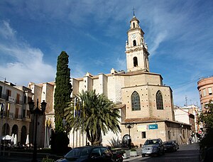
The Collegiate Basilica of Santa Maria of Gandia, also known as "La Seu", is the principal church of the city of Gandia, (Valencia). Construction commenced in the 14th century. The Collegiate Church of Santa María is a Valencian Gothic construction, located in the centre Gandia.
Archaeological Museum of Gandia
Distance: Approx. 532 meters
Latitude and longitude: 38.96696,-0.17786
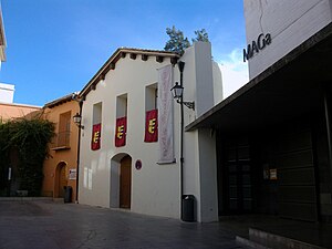
The Archaeological Museum of Gandia is a center where is shown the archaeological heritage of La Safor and Gandia area, but especially, the materials of the Parpalló cave. In 1972, with the collaboration of the Diputación de Valencia, was officially inaugurated the museum, now known by the acronym Maga, and is located in the old building of the Sant Marc Hospital, in the South-East end of the medieval walls of Gandia, on the left bank of the river Serpis. The museum was closed to the public during the period from 1987 to 2003.
Convent of Santa Clara of Gandia
Convent in Valencia, Spain
Distance: Approx. 534 meters
Latitude and longitude: 38.96745556,-0.17791111
The Convent of Santa Clara is 15th-century, Roman Catholic convent belonging to cloistered order of the Colettine Poor Clares, and located in the town of Gandia, province of Valencia, Spain. It is located in the centre of Gandia and at few meters from the Collegiate Basilica of Gandia, in María Enríquez de Luna square.
Oratory of the Borgias
Church in Canals , Spain
Distance: Approx. 327 meters
Latitude and longitude: 38.96696389,-0.18023333
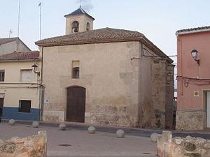
The Oratory of the Borgias or Church of the Tower is located in the municipality of Canals (Valencia), Spain. It is a church built in early Valencian Gothic style, probably in the 13th century. It is located in front of the Borgias Tower and has been reformed on several occasions.
Francis Borgia College, Gandia
School in Gandia, Valencia, Spain
Distance: Approx. 406 meters
Latitude and longitude: 38.9653,-0.17966389
Francis Borgia College, Gandia (Spanish: Colegio Borja), is a private Catholic multilingual nursery through secondary school (ESO), located in Gandia, Valencia, Spain. The origins of the school date to 1543 and is run by the Society of Jesus.The school shares space with the Jesuit community and the Ducal Palace of Gandia.
Weather in this IP's area
overcast clouds
14 Celsius
13 Celsius
13 Celsius
14 Celsius
1016 hPa
67 %
1016 hPa
992 hPa
10000 meters
1.79 m/s
2.68 m/s
205 degree
100 %


