Country:
Region:
City:
Latitude and Longitude:
Time Zone:
Postal Code:
IP information under different IP Channel
ip-api
Country
Region
City
ASN
Time Zone
ISP
Blacklist
Proxy
Latitude
Longitude
Postal
Route
Luminati
Country
Region
06
City
figueiradafozmunicipality
ASN
Time Zone
Europe/Lisbon
ISP
Nos Comunicacoes, S.A.
Latitude
Longitude
Postal
IPinfo
Country
Region
City
ASN
Time Zone
ISP
Blacklist
Proxy
Latitude
Longitude
Postal
Route
db-ip
Country
Region
City
ASN
Time Zone
ISP
Blacklist
Proxy
Latitude
Longitude
Postal
Route
ipdata
Country
Region
City
ASN
Time Zone
ISP
Blacklist
Proxy
Latitude
Longitude
Postal
Route
Popular places and events near this IP address

Figueira da Foz
Municipality in Centro, Portugal
Distance: Approx. 811 meters
Latitude and longitude: 40.15,-8.85
Figueira da Foz (Portuguese pronunciation: [fiˈɣɐjɾɐ ðɐ ˈfɔʃ] ), also known as Figueira for short, is a city and a municipality in the Coimbra District, in Portugal. Practically at the midpoint of the Iberian Peninsula's Atlantic coast, it is located at the mouth of the Mondego River, 40 km (25 mi) west of Coimbra and sheltered by hills (Serra da Boa Viagem), sharing about the same latitude with Philadelphia, Baku and Beijing. The population of the municipality in 2011 was 62,125, in an area of 379.05 km2 (146.35 sq mi).

Buarcos
Civil parish in Centro, Portugal
Distance: Approx. 2557 meters
Latitude and longitude: 40.166,-8.877
Buarcos is a freguesia (civil parish) in Figueira da Foz Municipality, Portugal. The population in 2011 was 18,454, in an area of 15.53 km². During the 1600s, the people of Buarcos were harassed by pirates and built the long fortification that stands to this day.
Estádio Municipal José Bento Pessoa
Stadium in Figueira da Foz, Portugal
Distance: Approx. 1678 meters
Latitude and longitude: 40.162675,-8.85936944
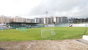
Estadio Municipal Jose Bento Pessoa is a multi-use stadium in Figueira da Foz, Portugal. It is currently used mostly for football matches and is home of the Naval 1º de Maio. The stadium is able to hold 10,000 people.
Tavarede
Civil parish in Centro, Portugal
Distance: Approx. 2466 meters
Latitude and longitude: 40.167,-8.845
Tavarede is a parish in the municipality of Figueira da Foz, Portugal. The population in 2011 was 9,441, in an area of 10.71 km2.
Alhadas
Civil parish in Centro, Portugal
Distance: Approx. 7127 meters
Latitude and longitude: 40.185,-8.791
Alhadas is a town in the municipality of Figueira da Foz, Portugal. The population in 2011 was 4,757, in an area of 31.84 km2.
Lavos (Figueira da Foz)
Civil parish in Centro, Portugal
Distance: Approx. 6490 meters
Latitude and longitude: 40.094,-8.829
Lavos is a seaside parish in Figueira da Foz Municipality, Portugal. The population in 2011 was 3,999, in an area of 42.02 km².

Cabo Mondego
Cape in Portugal
Distance: Approx. 6242 meters
Latitude and longitude: 40.19111111,-8.90527778
Cabo Mondego is a cape located in central western Portugal bordering the Atlantic Ocean. It is the westernmost point of the Serra da Boa Viagem and is located three kilometers north of Figueira da Foz. It is classified as a natural monument since 2007.

Serra da Boa Viagem
Distance: Approx. 4831 meters
Latitude and longitude: 40.19083333,-8.86388889
Serra da Boa Viagem is a mountain range in Portugal, it lies three kilometers north of Figueira da Foz. The range goes up to 261.9 m (859 ft) in altitude. Around 83% of its area is between 150 and 250 m (490 and 820 ft) high.

Castle of Redondos
Medieval castle in Portugal
Distance: Approx. 2631 meters
Latitude and longitude: 40.16677778,-8.87708333
The Castle of Redondos (Portuguese: Castelo de Redondos/Torre de Redondos) is a medieval castle located in the civil parish of Buarcos, in the municipality of Figueira da Foz, Portuguese Coimbra.

Fort Santa Catarina (Figueira da Foz)
Distance: Approx. 631 meters
Latitude and longitude: 40.14805556,-8.86638889
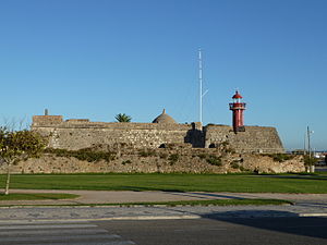
Fort Santa Catarina of Figueira da Foz is located in the parish of Buarcos, in the city and municipality of Figueira da Foz, district of Coimbra, in Portugal. It cooperated with the Fortress of Buarcos and the Palheiros Fortlet in the defense of the port and bay of Figueira da Foz and Buarcos. It houses the Santa Catarina Lighthouse.

Cape Mondego Lighthouse
Lighthouse in Portugal
Distance: Approx. 6242 meters
Latitude and longitude: 40.19111111,-8.90527778
The Cape Mondego Lighthouse (Portuguese: Farol do Cabo Mondego) is situated 3 nautical miles NNW of the Mondego River estuary on the Portuguese Atlantic coast, in the parish of Buarcos, in the Figueira da Foz Municipality, in the Coimbra District. It was constructed in 1922, replacing an earlier lighthouse to its south. The lighthouse has a square white masonry tower, 97 metres (318 ft) above sea level, together with annexes.

Maiorca halt
Closed halt in Portugal
Distance: Approx. 6259 meters
Latitude and longitude: 40.1752,-8.7949
The Maiorca halt was a railway halt of the shut down Ramal da Figueira da Foz, which served the town of Maiorca, Coimbra, Portugal, and closed in 2009.
Weather in this IP's area
few clouds
20 Celsius
20 Celsius
20 Celsius
20 Celsius
1018 hPa
70 %
1018 hPa
1018 hPa
10000 meters
1.94 m/s
1.84 m/s
273 degree
14 %
07:24:52
17:16:48
