Country:
 Portugal
Region:
City:
Latitude and Longitude:
Time Zone:
Postal Code:
IP information under different IP Channel
ip-api
Country
Region
City
ASN
Time Zone
ISP
Blacklist
Proxy
Latitude
Longitude
Postal
Route
IPinfo
Country
Region
City
ASN
Time Zone
ISP
Blacklist
Proxy
Latitude
Longitude
Postal
Route
MaxMind
Country
Region
City
ASN
Time Zone
ISP
Blacklist
Proxy
Latitude
Longitude
Postal
Route
Luminati
Country
PTRegion
08
City
quarteira
ASN
Time Zone
Europe/Lisbon
ISP
Nos Comunicacoes, S.A.
Latitude
Longitude
Postal
db-ip
Country
Region
City
ASN
Time Zone
ISP
Blacklist
Proxy
Latitude
Longitude
Postal
Route
ipdata
Country
Region
City
ASN
Time Zone
ISP
Blacklist
Proxy
Latitude
Longitude
Postal
Route
Popular places and events near this IP address
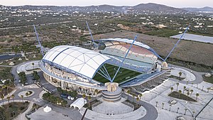
Estádio Algarve
Football stadium in Faro/Loulé, Portugal
Distance: Approx. 7154 meters
Latitude and longitude: 37.08833333,-7.97472222
The Estádio Algarve (transl. Algarve Stadium) is an association football stadium located between Faro and Loulé municipalities, in the Algarve region of Portugal. The stadium has a capacity of 30,305 and was purposely built for the UEFA Euro 2004 championship.

Loulé
Municipality in Algarve, Portugal
Distance: Approx. 2011 meters
Latitude and longitude: 37.15,-8
Loulé (locally [loˈlɛ] ) is a city and municipality in the region of Algarve, district of Faro, Portugal. In 2011, the population of the entire municipality was 70,622 inhabitants, in an area of approximately 763.67 square kilometres (294.85 sq mi). The municipality has two principal cities: Loulé (the seat of the municipality) and Quarteira.

Almancil
Civil parish in Algarve, Portugal
Distance: Approx. 6269 meters
Latitude and longitude: 37.086,-8.032
Almancil (Portuguese pronunciation: [almɐ̃ˈsil]) is a town and freguesia in the Loulé Municipality, in the affluent Golden Triangle region of the Algarve of southern Portugal. Almancil is known for its three Michelin star restaurants, the most of any town in the Algarve. The town had a population of 10,677 inhabitants in 2011, in an area of 62.30 square kilometres (24.05 sq mi).
Santa Bárbara de Nexe
Civil parish in Algarve, Portugal
Distance: Approx. 6563 meters
Latitude and longitude: 37.103,-7.964
Santa Bárbara de Nexe is a village and civil parish in the Portuguese municipality of Faro on the southern Algarve region. The population in 2011 was 4,116, in an area of 38.22 km². It is located a few kilometers from both the cities of Loulé and Faro.

Church of São Lourenço (Almancil)
Church in Algarve, Portugal
Distance: Approx. 6686 meters
Latitude and longitude: 37.08208611,-8.00894167
The Church of São Lourenço (Portuguese: Igreja de São Lourenço) is a Church in the civil parish of Almancil, in the municipality of Loulé in the Portuguese Algarve.
Querença
Civil Parish in Algarve, Portugal
Distance: Approx. 6999 meters
Latitude and longitude: 37.19888889,-7.98777778
Querença (European Portuguese pronunciation: [kɨɾẽsɐ]) is a former civil parish in the municipality of Loulé, eastern Algarve, Portugal. In 2013, the parish merged into the new parish Querença, Tôr e Benafim. Located north of Loulé proper, Querença is an area of 37.18 square kilometres (14.36 sq mi) with a population of 759 inhabitants (based on 2011 census).
Querença, Tôr e Benafim
Civil parish in Algarve, Portugal
Distance: Approx. 7035 meters
Latitude and longitude: 37.2,-7.99
Querença, Tôr e Benafim is a civil parish in the municipality of Loulé, Portugal. It was formed in 2013 by the merger of the former parishes Querença, Tôr and Benafim. The population in 2011 was 2,713, in an area of 102.18 km².

Vilamoura Old Course
Distance: Approx. 9754 meters
Latitude and longitude: 37.10194444,-8.11805556
Vilamoura Old Course is a golf course in Vilamoura, on the Algarve in Southern Portugal. Sometimes referred to as the "Grande Dame" of the Algarve, it is owned and operated by Dom Pedro Hotels & Golf Collection, who purchased the course, along with four others in Vilamoura, in 2016. The five courses had previously been owned by the Oceanico Group since 2007.
International School São Lourenço
School in Portugal
Distance: Approx. 4637 meters
Latitude and longitude: 37.1,-8.02445
International School São Lourenço (ISSL) is an international school located in Almancil in Algarve, Portugal. Founded in 1978 and a private fee-paying school, ISSL is a nonprofit organisation. It has been run since 2006 by a Board of Governors composed of parents elected by the Parent Teacher Association (PTA).

Castle of Loulé
Castle in Loulé, Portugal
Distance: Approx. 414 meters
Latitude and longitude: 37.13944444,-8.02388889
Castle of Loulé (Portuguese: Castelo de Loulé) is a castle in the municipality of Loulé, in the Portuguese Algarve. Classified a National Monument, since 20 June 1924, three towers remain within the cordon of walls, the remnants of the town hall located within the structure.

Algibre River
River of the Algarve, Portugal
Distance: Approx. 5694 meters
Latitude and longitude: 37.19163889,-8.00727778
The Algibre River (Portuguese pronunciation: [alˈʒiβɾɨ]) is a small river in the Portuguese region of the Algarve. The Algibre River is formed by the confluence of the Mercês (Ribeira das Mercês) and Benémola (Ribeira da Benémola) rivers close to the village of Querença in a small fertile valley. The area is characterized by many derelict sluices and dams that date back to the period of Arab occupation, during which the whole area was irrigated and agriculture was the predominating activity of this land.
Weather in this IP's area
clear sky
20 Celsius
20 Celsius
19 Celsius
22 Celsius
1018 hPa
56 %
1018 hPa
996 hPa
10000 meters
2.57 m/s
270 degree
07:26:44
19:17:02