Country:
 Portugal
Region:
City:
Latitude and Longitude:
Time Zone:
Postal Code:
IP information under different IP Channel
ip-api
Country
Region
City
ASN
Time Zone
ISP
Blacklist
Proxy
Latitude
Longitude
Postal
Route
IPinfo
Country
Region
City
ASN
Time Zone
ISP
Blacklist
Proxy
Latitude
Longitude
Postal
Route
MaxMind
Country
Region
City
ASN
Time Zone
ISP
Blacklist
Proxy
Latitude
Longitude
Postal
Route
Luminati
Country
PTRegion
11
City
sacavem
ASN
Time Zone
Europe/Lisbon
ISP
Nos Comunicacoes, S.A.
Latitude
Longitude
Postal
db-ip
Country
Region
City
ASN
Time Zone
ISP
Blacklist
Proxy
Latitude
Longitude
Postal
Route
ipdata
Country
Region
City
ASN
Time Zone
ISP
Blacklist
Proxy
Latitude
Longitude
Postal
Route
Popular places and events near this IP address
Sacavém
Civil parish in Lisbon, Portugal
Distance: Approx. 408 meters
Latitude and longitude: 38.79444444,-9.10527778
Sacavém (Portuguese pronunciation: [sɐkɐˈvɐ̃j]; Arabic: شقبان) is a city and former civil parish in the municipality of Loures, Lisbon District, Portugal. In 2013, the parish merged into the new parish Sacavém e Prior Velho. It is a few kilometers north-east of the Portuguese capital, Lisbon.
Camarate
Civil parish in Lisbon, Portugal
Distance: Approx. 2389 meters
Latitude and longitude: 38.79802778,-9.13393611
Camarate (Portuguese pronunciation: [kɐmɐˈɾatɨ]) is a former civil parish in the municipality of Loures, Lisbon District, Portugal. In 2013, the parish merged into the new parish Camarate, Unhos e Apelação. With a population of 23,000 inhabitants in 2001, the parish of Camarate extends into an area of 5.52 km².

Portela (Loures)
Civil parish in Lisbon, Portugal
Distance: Approx. 1605 meters
Latitude and longitude: 38.78472222,-9.11361111
Portela (Portuguese pronunciation: [puɾˈtɛlɐ]) is a former civil parish in the municipality of Loures, Lisbon District, Portugal. In 2013, the parish merged into the new parish Moscavide e Portela.
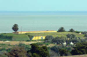
Estádio Alfredo Marques Augusto
Distance: Approx. 2688 meters
Latitude and longitude: 38.774,-9.103
Estádio Alfredo Marques Augusto is a stadium in Lisbon, Portugal. It is currently used mostly for football matches and it is the home stadium of CD Olivais e Moscavide. The stadium is able to hold 2,730 people.
Sacavém e Prior Velho
Civil parish in Lisbon, Portugal
Distance: Approx. 574 meters
Latitude and longitude: 38.793,-9.108
Sacavém e Prior Velho is a civil parish in the municipality of Loures, Portugal. It was formed in 2013 by the merger of the former parishes Sacavém and Prior Velho. The population in 2011 was 24,822, in an area of 3.89 km².

Moscavide Station (Lisbon Metro)
Metro station in Lisbon, Portugal
Distance: Approx. 2583 meters
Latitude and longitude: 38.775,-9.1025
Moscavide is a station on the Red Line of the Lisbon Metro. The station is in the parish of Moscavide in the Municipality of Loures, bordering Lisbon, and is located in Rua João Pinto Ribeiro beside Estádio Alfredo Marques Augusto. The station, designed by the architect Manuel Bastos, opened in July 2012 in conjunction with the Encarnação and Aeroporto stations, as part of the expansion of the line to serve Lisbon Portela Airport.

Army Geospatial Information Center
Military unit
Distance: Approx. 2283 meters
Latitude and longitude: 38.7783,-9.1137
The Army Geospatial Information Center (Portuguese: Centro de Informação Geoespacial do Exército; CIGeoE) is the military geographical, cartographical and geospatial intelligence agency of the Portuguese Army. The main mission of the CIGeoE is to provide the Army and the other branches of the Armed Forces of Portugal, as well as the civil community, with geographic information, ensuring the implementation of activities related to the geographical science, cartographic technique and the promotion and development of scientific and technological research actions in the field of geographical support and geomatics. This mission includes the geospatial intelligence (GEOINT) and imagery intelligence (IMINT) activities in support of the Armed Forces.
Camarate, Unhos e Apelação
Civil parish in Lisbon, Portugal
Distance: Approx. 1926 meters
Latitude and longitude: 38.802,-9.128
Camarate, Unhos e Apelação is a civil parish in the municipality of Loures, Portugal. It was formed in 2013 by the merger of the former parishes Camarate, Unhos and Apelação. The population in 2011 was 34,943, in an area of 11.57 km².
Moscavide e Portela
Civil parish in Lisbon, Portugal
Distance: Approx. 2136 meters
Latitude and longitude: 38.779,-9.103
Moscavide e Portela is a civil parish in the municipality of Loures, Portugal. It was formed in 2013 by the merger of the former parishes Moscavide and Portela. The population in 2011 was 21,891, in an area of 1.66 km².
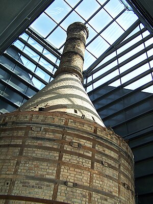
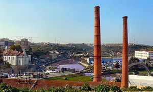
Ceramics Museum of Sacavém
Museum near Lisbon, Portugal
Distance: Approx. 546 meters
Latitude and longitude: 38.794187,-9.102438
The Ceramics Museum of Sacavém (Portuguese: Museu de Cerâmica de Sacavém) is situated in the town of Sacavém in the municipality of Loures, just northeast of Lisbon in Portugal. The museum was opened in July 2000 and was constructed on the grounds of a former ceramics factory. Most of the exhibits reflect the output of that factory and its documentation centre is devoted to the study of the history and production of the factory and the industrial heritage of the municipality.
Fort of Sacavém
19th-century fort in Portugal
Distance: Approx. 489 meters
Latitude and longitude: 38.795833,-9.1015
The Redoubt of Mount Cintra (or Mount Sintra), commonly known as the Fort of Sacavém, is located in the town of Sacavém in the municipality of Loures in the Lisbon District of Portugal. It is situated immediately to the north of Lisbon. The fort’s construction began in 1875 and was completed in 1892.
Trancão River
River in Portugal
Distance: Approx. 1438 meters
Latitude and longitude: 38.79611111,-9.09
The Trancão River (Portuguese pronunciation: [tɾɐ̃ˈkɐ̃w]), formerly called Rio de Sacavém, is a small river in Portugal (about 29 km) from District of Lisbon. Near its mouth, this watercourse can also be called Ribeira de Sacavém ou Vala de Sacavém.
Weather in this IP's area
clear sky
20 Celsius
20 Celsius
19 Celsius
21 Celsius
1019 hPa
79 %
1019 hPa
1018 hPa
10000 meters
5.14 m/s
310 degree
07:31:32
19:20:55