Country:
 Switzerland
Region:
City:
Latitude and Longitude:
Time Zone:
Postal Code:
IP information under different IP Channel
ip-api
Country
Region
City
ASN
Time Zone
ISP
Blacklist
Proxy
Latitude
Longitude
Postal
Route
IPinfo
Country
Region
City
ASN
Time Zone
ISP
Blacklist
Proxy
Latitude
Longitude
Postal
Route
MaxMind
Country
Region
City
ASN
Time Zone
ISP
Blacklist
Proxy
Latitude
Longitude
Postal
Route
Luminati
Country
CHRegion
zh
City
unterengstringen
ASN
Time Zone
Europe/Zurich
ISP
green.ch AG
Latitude
Longitude
Postal
db-ip
Country
Region
City
ASN
Time Zone
ISP
Blacklist
Proxy
Latitude
Longitude
Postal
Route
ipdata
Country
Region
City
ASN
Time Zone
ISP
Blacklist
Proxy
Latitude
Longitude
Postal
Route
Popular places and events near this IP address
Arni, Aargau
Municipality in Aargau, Switzerland
Distance: Approx. 3545 meters
Latitude and longitude: 47.319445,8.42222167
Arni is a municipality in the district of Bremgarten in the Swiss canton of Aargau.

Oberwil-Lieli
Municipality in Aargau, Switzerland
Distance: Approx. 3203 meters
Latitude and longitude: 47.33333333,8.4
Oberwil-Lieli is a municipality in the district of Bremgarten in the canton of Aargau in Switzerland.

Wettswil am Albis
Municipality in Zurich, Switzerland
Distance: Approx. 3074 meters
Latitude and longitude: 47.33333333,8.46666667
Wettswil am Albis is a municipality in the district of Affoltern in the canton of Zürich in Switzerland.

Aesch, Zürich
Municipality in Zurich, Switzerland
Distance: Approx. 1879 meters
Latitude and longitude: 47.33333333,8.43333333
Aesch is a municipality in the district of Dietikon in the canton of Zürich in Switzerland. Until 2001 it was known as Aesch bei Birmensdorf.

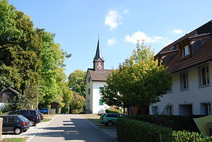
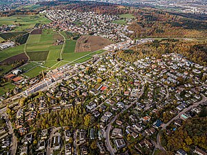
Birmensdorf
Municipality in Zurich, Switzerland
Distance: Approx. 83 meters
Latitude and longitude: 47.35,8.43333333
Birmensdorf is a municipality in the district of Dietikon in the canton of Zürich in Switzerland.
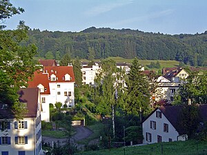
Uitikon
Municipality in Zurich, Switzerland
Distance: Approx. 2178 meters
Latitude and longitude: 47.36666667,8.45
Uitikon is a village and municipality in the district of Dietikon in the canton of Zürich in Switzerland. Besides the village of Uitikon itself, the municipality includes the villages of Waldegg and Ringlikon.
Urdorf
Municipality in Zurich, Switzerland
Distance: Approx. 3689 meters
Latitude and longitude: 47.38333333,8.43333333
Urdorf is a municipality in the district of Dietikon in the canton of Zürich in Switzerland, located in the Limmat Valley (German: Limmattal).
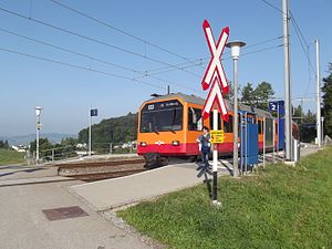
Uitikon Waldegg railway station
Railway station in the municipality of Uitikon in the Swiss canton of Zürich
Distance: Approx. 2955 meters
Latitude and longitude: 47.3659,8.466
Uitikon Waldegg is a railway station in the village of Waldegg in the municipality of Uitikon in Switzerland. The station is on the Uetliberg line, which is operated by the Sihltal Zürich Uetliberg Bahn (SZU). The station is served by the following passenger trains: The station is connected, by PostAuto bus route 201, with the villages of Uitikon and Ringlikon.
Ringlikon railway station
Railway station in the municipality of Uitikon in the Swiss canton of Zürich
Distance: Approx. 3423 meters
Latitude and longitude: 47.35999,8.477433
Ringlikon is a railway station situated near the village of Ringlikon in the municipality of Uitikon in Switzerland. The station is on the Uetliberg line, which is operated by the Sihltal Zürich Uetliberg Bahn (SZU). The station is served by the following passenger trains: The station has a passing loop and two side platforms, and has no station buildings.

Urdorf Weihermatt railway station
Railway station in Switzerland
Distance: Approx. 3439 meters
Latitude and longitude: 47.380958,8.430207
Urdorf Weihermatt is a railway station in the municipality of Urdorf, in the Swiss canton of Zurich. The station is located on the Zurich to Zug via Affoltern am Albis railway line. Urdorf Weihermatt railway station should not be confused with Urdorf railway station, situated some 1.25 kilometres (0.78 mi) away on the same line and served by the same trains.
Birmensdorf railway station
Railway station in Switzerland
Distance: Approx. 851 meters
Latitude and longitude: 47.35761,8.437189
Birmensdorf is a railway station in the municipality of Birmensdorf, in the Swiss canton of Zurich. The station is located on the Zurich to Zug via Affoltern am Albis railway line.
Swiss Federal Institute for Forest, Snow and Landscape Research
Swiss research institution
Distance: Approx. 1918 meters
Latitude and longitude: 47.3604,8.4549
The Swiss Federal Institute for Forest, Snow and Landscape Research WSL (short WSL, German: Eidgenössische Forschungsanstalt für Wald, Schnee und Landschaft WSL, French: Institut fédéral de recherches sur la forêt, la neige et le paysage WSL, Italian: Istituto federale di ricerca per la foresta, la neve e il paesaggio WSL) is a solution-orientated research organisation specialising in on forests, landscapes, biodiversity, natural hazards, snow and ice in a changing world. As a federal research institute and part of the ETH Domain, WSL is committed to excellence in research and implementation. As of the end of 2024, WSL employed approximately 650 people.
Weather in this IP's area
fog
13 Celsius
12 Celsius
11 Celsius
14 Celsius
1013 hPa
95 %
1013 hPa
956 hPa
600 meters
100 %
07:49:12
18:33:11