81.5.194.169 - IP Lookup: Free IP Address Lookup, Postal Code Lookup, IP Location Lookup, IP ASN, Public IP
Country:
Region:
City:
Location:
Time Zone:
Postal Code:
IP information under different IP Channel
ip-api
Country
Region
City
ASN
Time Zone
ISP
Blacklist
Proxy
Latitude
Longitude
Postal
Route
Luminati
Country
Region
3
City
alland
ASN
Time Zone
Europe/Vienna
ISP
Telekom Austria
Latitude
Longitude
Postal
IPinfo
Country
Region
City
ASN
Time Zone
ISP
Blacklist
Proxy
Latitude
Longitude
Postal
Route
IP2Location
81.5.194.169Country
Region
burgenland
City
jois
Time Zone
Europe/Vienna
ISP
Language
User-Agent
Latitude
Longitude
Postal
db-ip
Country
Region
City
ASN
Time Zone
ISP
Blacklist
Proxy
Latitude
Longitude
Postal
Route
ipdata
Country
Region
City
ASN
Time Zone
ISP
Blacklist
Proxy
Latitude
Longitude
Postal
Route
Popular places and events near this IP address
Neusiedl am See
Municipality in Burgenland, Austria
Distance: Approx. 4231 meters
Latitude and longitude: 47.95,16.85
Neusiedl am See (Austrian German: [ˈnɔʏˌsiːdl̩ am ˈseː] ; Czech: Nezider; Croatian: Niuzalj; Hungarian: Nezsider; Slovak: Nezider) is a town in Burgenland, Austria, and administrative center of the district of Neusiedl am See. Neusiedl am See is located on the northern shore of Lake Neusiedl.

Bruck an der Leitha
Municipality in Lower Austria, Austria
Distance: Approx. 6497 meters
Latitude and longitude: 48.01666667,16.76666667
Bruck an der Leitha (Central Bavarian: Bruck aun da Leitha; "Bridge on the Leitha") is a town in the Austrian state of Lower Austria on the border of Burgenland, marked by the Leitha river. In 2018 it had a population of around 8,000.

Purbach am Neusiedlersee
Municipality in Burgenland, Austria
Distance: Approx. 8740 meters
Latitude and longitude: 47.91666667,16.7
Purbach am Neusiedlersee (Hungarian: Feketeváros), which is sometimes written as Purbach am Neusiedler See or Purbach am See, is a town in the Austrian state of Burgenland known for its viticulture. It lies in the Eisenstadt-Umgebung district. Purbach is located at the western shores of Neusiedler See, the only steppe lake in Central Europe, and the only lake without natural outflow in Europe.
Breitenbrunn am Neusiedler See
Municipality in Burgenland, Austria
Distance: Approx. 5034 meters
Latitude and longitude: 47.94583333,16.73277778
Breitenbrunn am Neusiedler See (Hungarian: Fertőszéleskút, Croatian: Patipron) is a small wine village in the district of Eisenstadt-Umgebung in the Austrian state of Burgenland.

Bruckneudorf
Municipality in Burgenland, Austria
Distance: Approx. 6497 meters
Latitude and longitude: 48.01666667,16.76666667
Bruckneudorf (Hungarian: Királyhida) is a small town in the district of Neusiedl am See in the federal state of Burgenland in Austria, neighbouring Bruck an der Leitha ("Leitha Bridge"). Its name means bridge new village, whereas the Hungarian version means royal bridge, and the royal refers to King Francis I. Historically and geographically, Bruckneudorf represents the extension of the Austrian town of Bruck an der Leitha over the Austrian border into Hungary. This border, symbolised by the river Leitha, separated the Austrian Empire from the Kingdom of Hungary (Cisleithania and Transleithania).

Jois
Municipality in Burgenland, Austria
Distance: Approx. 1336 meters
Latitude and longitude: 47.95,16.8
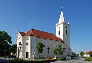
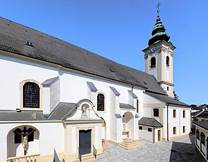
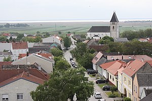
Jois (German pronunciation: [jɔɪ̯s] ; Hungarian: Nyulas) is a small town in the district of Neusiedl am See in Burgenland in Eastern Austria. It is on the northern shore of Lake Neusiedl, which straddles the border with Hungary. The picturesque wine-producing area is popular with tourists, who visit Jois's parish church with its Baroque statues dating back to 1757, the local heritage museum with the district's school museum, wayside shrines, cycling trails, and the wine trail.

Parndorf
Municipality in Burgenland, Austria
Distance: Approx. 4063 meters
Latitude and longitude: 47.96666667,16.85
Parndorf (Hungarian: Pándorfalu, Croatian: Pandrof) is a town in the district of Neusiedl am See in the Austrian state of Burgenland. Its original ancient name Perun is derived from the Slavic deity Perun.

Weiden am See
Municipality in Burgenland, Austria
Distance: Approx. 7273 meters
Latitude and longitude: 47.91666667,16.86666667
Weiden am See (Hungarian: Védeny) is a town in the district of Neusiedl am See in the Austrian state of Burgenland.
Winden am See
Municipality in Burgenland, Austria
Distance: Approx. 3668 meters
Latitude and longitude: 47.95,16.75
Winden am See (Hungarian: Sásony) is a town in the district of Neusiedl am See in the Austrian state of Burgenland.

Kalvarienberg (nature reserve)
Distance: Approx. 5260 meters
Latitude and longitude: 47.943073,16.860842
Kalvarienberg is a nature monument in Neusiedl am See in the state of Burgenland, Austria. The nature monument covers the steep south-eastern slope of the Parndorf Plain, the Wagram.

Burgenland corpses discovery
2015 death of 71 migrants in a lorry in Austria
Distance: Approx. 5338 meters
Latitude and longitude: 48.0032585,16.8317331
On 27 August 2015, the bodies of 71 illegal immigrants were discovered in a lorry on the Ost Autobahn in Burgenland, Austria. The victims were part of the wave of many thousands of migrants who traveled through the western Balkans in an effort to reach Germany. The borders were opened shortly afterward to allow the influx across.

The Pit (Breitenbrunn am Neusiedlersee, Austria)
Distance: Approx. 5318 meters
Latitude and longitude: 47.95155,16.7263
The Pit (Breitenbrunn am Neusiedlersee, Austria) is a land art project by Peter Noever in Breitenbrunn which has existed since the early 1970s and in 2019 was placed under monument protection by the Austrian Federal Office BDA.
Weather in this IP's area
clear sky
-0 Celsius
-5 Celsius
-1 Celsius
1 Celsius
1037 hPa
79 %
1037 hPa
1019 hPa
10000 meters
5.07 m/s
10.51 m/s
329 degree
9 %


