81.4.110.96 - IP Lookup: Free IP Address Lookup, Postal Code Lookup, IP Location Lookup, IP ASN, Public IP
Country:
Region:
City:
Location:
Time Zone:
Postal Code:
IP information under different IP Channel
ip-api
Country
Region
City
ASN
Time Zone
ISP
Blacklist
Proxy
Latitude
Longitude
Postal
Route
Luminati
Country
Region
nh
City
amsterdam
ASN
Time Zone
Europe/Amsterdam
ISP
RouteLabel V.O.F.
Latitude
Longitude
Postal
IPinfo
Country
Region
City
ASN
Time Zone
ISP
Blacklist
Proxy
Latitude
Longitude
Postal
Route
IP2Location
81.4.110.96Country
Region
zuid-holland
City
papendrecht
Time Zone
Europe/Amsterdam
ISP
Language
User-Agent
Latitude
Longitude
Postal
db-ip
Country
Region
City
ASN
Time Zone
ISP
Blacklist
Proxy
Latitude
Longitude
Postal
Route
ipdata
Country
Region
City
ASN
Time Zone
ISP
Blacklist
Proxy
Latitude
Longitude
Postal
Route
Popular places and events near this IP address

Drechtsteden
Distance: Approx. 1734 meters
Latitude and longitude: 51.81666667,4.68333333
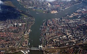
The Drechtsteden (Dutch pronunciation: [ˈdrɛxtsteːdə(n)]; Dutch for "Drecht cities") are a number of towns and cities bordering each other in the delta area of the rivers Oude Maas, Noord, and Beneden-Merwede in the province of South Holland, Netherlands. These cooperate in the Gemeenschappelijke Regeling Drechtsteden ("joint arrangement Drechtsteden"), which performs common tasks for the municipalities in the field of economy, development, culture, and social assistance. Collectively, a little more than 250,000 people call one of the towns and cities of Drechtsteden home.
Papendrecht
Municipality in South Holland, Netherlands
Distance: Approx. 341 meters
Latitude and longitude: 51.83333333,4.68333333
Papendrecht (Dutch pronunciation: [ˈpaːpə(n)drɛxt] ) is a town and municipality in the western Netherlands, in the province of South Holland, at the crossing of the River Beneden Merwede and the Noord River. The municipality had a population of 32,171 in 2021 and covers an area of 10.79 km2 (4.17 sq mi) of which 1.38 km2 (0.53 sq mi) is water. Although Papendrecht is first mentioned in documents dating back to 1105, it remained a small settlement until the 1950s.

Beneden Merwede
Distance: Approx. 1702 meters
Latitude and longitude: 51.817,4.683
The Beneden Merwede (Dutch pronunciation: [bəˌneːdə ˈmɛrʋeːdə]; "Lower Merwede") is a stretch of river in the Netherlands, mainly fed by the river Rhine. It starts as the continuation of the Boven Merwede after the branching-off of the Nieuwe Merwede ship canal. It flows from Hardinxveld-Giessendam to Dordrecht, where it splits into the Noord and Oude Maas rivers.

Merwede
River in the Netherlands
Distance: Approx. 2242 meters
Latitude and longitude: 51.81666667,4.66666667
The Merwede (Dutch pronunciation: [ˈmɛrʋeːdə]; etymology uncertain, possibly derived from the Old Dutch merwe or merowe, a word meaning "wide water") is the name of several connected stretches of river in the Netherlands, between the cities of Woudrichem, Dordrecht and Papendrecht. The river is part of the Rhine–Meuse–Scheldt delta and is mostly fed by the river Rhine. At first, a disconnected branch of the Meuse joins the Waal at Woudrichem to form the Boven Merwede (Upper Merwede).

Johan's Ark
Reconstruction of Noah's Ark, Netherlands
Distance: Approx. 1446 meters
Latitude and longitude: 51.81912222,4.68506667
Johan's Ark is a Noah's Ark-themed barge in Dordrecht, Netherlands, which was built by the Dutch building contractor, carpenter and creationist Johan Huibers. It is a full-scale interpretation of the biblical Ark, featuring animal models, including cows, penguins, a crocodile, and a giraffe. It opened to the public in 2012.

Dordrecht railway station
Railway station in the Netherlands
Distance: Approx. 3056 meters
Latitude and longitude: 51.8075,4.66777778
Dordrecht is a railway station in Dordrecht, Netherlands located on the Breda–Rotterdam railway and the Elst–Dordrecht railway. The station was opened on 1 January 1872, when the railway line between Rotterdam and Antwerp was opened. On 16 July 1885, the railway line from Dordrecht to Gorinchem was opened.

Noord (river)
River in South Holland, Netherlands
Distance: Approx. 2965 meters
Latitude and longitude: 51.85111111,4.65777778
The Noord ("North") is a short tidal river in the western Netherlands, in the province of South Holland. The Noord starts at the city of Dordrecht where the Beneden Merwede river forks into the Oude Maas and the Noord. It joins the Lek at the city of Ridderkerk and Kinderdijk, and the combined stream is thereafter known as the Nieuwe Maas.

Dordrecht City Hall
Distance: Approx. 2602 meters
Latitude and longitude: 51.81361111,4.66444444
The City Hall in Dordrecht is a renaissance building decorated in neoclassic style on the Stadhuisplein and over one of the city harbors; the Voorstraathaven. It is the seat of the city's government, which first received city rights in 1220, and today it is still the place where residents often hold their civic wedding ceremonies.
Matena, Netherlands
Village in South Holland, Netherlands
Distance: Approx. 3050 meters
Latitude and longitude: 51.82805556,4.73166667
Matena is a small village in the west of the Netherlands. It is located in the municipality of Papendrecht, South Holland, east of the town Papendrecht.

Groothoofdspoort
City Gate in Dordrecht
Distance: Approx. 1846 meters
Latitude and longitude: 51.81944444,4.67027778
The Groothoofdspoort is a former city gate in Dordrecht that is located at the point where three rivers meet; the Merwede, the Oude Maas, and the Noord.
Grote Kerk, Dordrecht
Church in Netherlands
Distance: Approx. 2757 meters
Latitude and longitude: 51.81416667,4.66
The Grote Kerk of Dordrecht, officially the Church of Our Lady (Dutch: Onze-Lieve-Vrouwekerk, or Grote Kerk) is a large church in the Brabantine Gothic style, and the largest church in the city. It was built between 1284 and 1470, though some parts are newer. It became a Protestant church in 1572, and remains an active church, now owned by the Protestant Church in the Netherlands.

Binnenvaartmuseum
Maritime museum in Dordrecht, Netherlands
Distance: Approx. 1651 meters
Latitude and longitude: 51.8172,4.6863
Binnenvaartmuseum ('Inland Shipping Museum') is a floating museum in Dordrecht, South Holland, Netherlands, on the Wantij waterway near the former shipyard De Biesbosch.
Weather in this IP's area
broken clouds
5 Celsius
5 Celsius
4 Celsius
6 Celsius
1039 hPa
79 %
1039 hPa
1039 hPa
10000 meters
0.45 m/s
1.79 m/s
18 degree
58 %

