Country:
Region:
City:
Latitude and Longitude:
Time Zone:
Postal Code:
IP information under different IP Channel
ip-api
Country
Region
City
ASN
Time Zone
ISP
Blacklist
Proxy
Latitude
Longitude
Postal
Route
Luminati
Country
ASN
Time Zone
Asia/Tehran
ISP
Sharif University Of Technology
Latitude
Longitude
Postal
IPinfo
Country
Region
City
ASN
Time Zone
ISP
Blacklist
Proxy
Latitude
Longitude
Postal
Route
db-ip
Country
Region
City
ASN
Time Zone
ISP
Blacklist
Proxy
Latitude
Longitude
Postal
Route
ipdata
Country
Region
City
ASN
Time Zone
ISP
Blacklist
Proxy
Latitude
Longitude
Postal
Route
Popular places and events near this IP address

Sharif University of Technology
One of the most prestigious universities in Iran
Distance: Approx. 41 meters
Latitude and longitude: 35.70179722,51.35143889
Sharif University of Technology (SUT); (Persian: دانشگاه صنعتی شریف, romanized : Dāneshgāh-e sana'ti-e sharif) is a public research university in Tehran, Iran. Nicknamed "the MIT of Iran", it is widely considered to be the nation's most prestigious and leading institution for science, technology, engineering, and mathematics (STEM) fields. Every year, the smartest and the most prospective students in Iran, ranked according to the results of the Iranian University Entrance Exam, choose to study at SUT at Bachelor's, Master's as well as PhD levels.

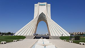
Azadi Tower
Building in Tehran, Iran
Distance: Approx. 1279 meters
Latitude and longitude: 35.69944444,51.33777778
The Azadi Tower (Persian: برج آزادی, Borj-e Āzādi; "Freedom Tower"), formerly known as the Shahyad Tower (برج شهیاد, Borj-e Šahyād; "Shah's Memorial Tower"), is a monument on Azadi Square in Tehran, Iran. It is one of the landmarks of Tehran, marking the west entrance to the city, and is part of the Azadi Cultural Complex, which also includes an underground museum. The tower is about 45 metres (148 ft) tall and is completely clad in cut marble.

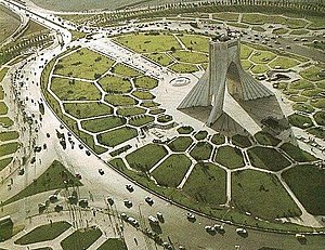
Azadi Square
City square in Tehran, Iran
Distance: Approx. 1324 meters
Latitude and longitude: 35.69972222,51.33722222
Azadi Square (Persian: میدان آزادی Meydāne Āzādi meaning "Freedom Square" or "Liberty Square"), formerly known as Shahyad Square (Persian: میدان شهیاد Meydāne Ŝahyād meaning "Remembrance of [the] Shah Square"), is a mainly green city square in Tehran, Iran. It hosts as its centerpiece the Azadi Tower. The tower and square were commissioned by Mohammad Reza Pahlavi, the last Shah of Iran, to mark the 2,500-year celebration of the Persian Empire.

Shademan Metro Station
Station of the Tehran Metro
Distance: Approx. 1786 meters
Latitude and longitude: 35.70111111,51.33194444
Shademan Metro Station is a station on Tehran Metro Line 2 and Line 4. It is located in the junction of Azadi Street and Azarbayjan Street. It is between Navvab Metro Station and Sharif University Metro Station.
Daneshgah-e Sharif Metro Station
Station of the Tehran Metro
Distance: Approx. 509 meters
Latitude and longitude: 35.7058,51.3536
Sharif University Metro Station is a station on Tehran Metro Line 2. It is located at the junction of Sohravard Street and Dr. Habibollah Street.
Tarasht Metro Station
Station of the Tehran Metro
Distance: Approx. 1786 meters
Latitude and longitude: 35.7161,51.3435
Tarasht Metro Station is a station on Tehran Metro Line 2. It is located on Shahid Golab Street. It is between the Sharif University Metro Station and the Sadeghieh (Tehran) Metro Station.

Ministry of Labour and Social Affairs (Iran)
Distance: Approx. 1422 meters
Latitude and longitude: 35.70094722,51.36741944
Ministry of Labour and Social Affairs of Iran (Persian: وزارت کار و امور اجتماعی, Vâzart-e Kaz-e vâ Amvâz-e Ajtema'i), was the main organ of Iranian Government in charge of the regulation and implementation of policies applicable to labour and social affairs.
University of Applied Science and Technology
Public university in Iran
Distance: Approx. 41 meters
Latitude and longitude: 35.70179722,51.35143889
The University of Applied Science and Technology (UAST) (Persian: دانشگاه جامع علمی - کاربردی Dāneshgah-e Jām'e Elmi Kārbordi) is a public university in Iran administrated by the Ministry of Science, Research and Technology. It was established in 1992 and has 1500 education centers in various Provinces of Iran. This university helps to increase skill level of employed personnel in various sectors of economic field and graduates of higher education and professional skills that are lacking in administrative.

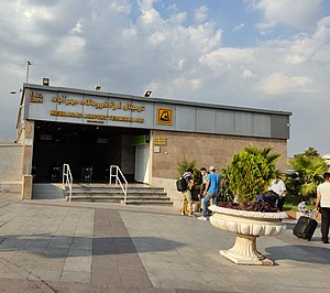
Mehrabad Airport Terminal 4 and 6 station
Station of the Tehran Metro
Distance: Approx. 2340 meters
Latitude and longitude: 35.68805556,51.33180556
Mehrabad Airport Terminal 4 and 6 station is a station in Tehran Metro Line 4's Mehrabad Branch, branching off from Bimeh Metro Station. It is located in Mehrabad Airport serving Terminal pairs 4 and 6. Terminals 4 and 6 have the following function: Terminals 4 and 6 handle departures (Terminal 4) and arrivals (Terminal 6) for airlines other than Iran Air, Iran Air Tours, Meraj Airlines, Qeshm Air, Ata Airlines, Kish Air, Chabahar Airlines and Zagros Airlines.
Soore University
University
Distance: Approx. 1706 meters
Latitude and longitude: 35.7002,51.3705
Soore University (SU) (Persian: دانشگاه سوره, Dânešgâh-e Sure) is an International non-for-profit university located in Tehran, Iran. Soore University was founded in 1994, and it is considered among the top art universities in Iran alongside Tehran University of Art and College of Fine Arts at University of Tehran. Historically, Soore University has been particularly strong in Graphic Design and Cinema among arts.
Iran Technical and Vocational Training Organization
Technical and Vocational Training Government Agency of Iran
Distance: Approx. 1860 meters
Latitude and longitude: 35.7002385,51.3722132
The Iran Technical and Vocational Training Organization or in brief I.R.T.V.T.O is one of the organizations affiliated to the Ministry of Cooperatives, Labour, and Social Welfare, which was formed from the merger of three educational institutions in 1980 in order to provide technical and vocational education. In addition to the central headquarters, this organization has 31 general administrations in provinces of Iran, an instructor training center, 552 Learning Center and over 11700 free technical and vocational schools. In order to achieve the latest science and technology news and to comply with international standards, the organization always tried to expand international relations, including with the International Labour Organization and the International Organization for Vocational Training in other countries.
Geological Survey and Mineral Exploration of Iran
Iranian Geological & Mineral Exploration government agency
Distance: Approx. 1868 meters
Latitude and longitude: 35.696634,51.331928
The Geological Survey and Mineral Exploration of Iran or in brief GSI is a government agency responsible for conducting geological and mineral surveys throughout the country, collecting the results of activities carried out in this field, establishing coordination, preparing and publishing geological maps of Iran. It is a subdivision of the Ministry of Industry, Mine and Trade, which was established in 1962 in cooperation with United Nations.
Weather in this IP's area
broken clouds
11 Celsius
10 Celsius
9 Celsius
11 Celsius
1023 hPa
71 %
1023 hPa
889 hPa
8000 meters
2.06 m/s
320 degree
75 %
06:34:40
17:02:17