Country:
 Norway
Region:
City:
Latitude and Longitude:
Time Zone:
Postal Code:
IP information under different IP Channel
ip-api
Country
Region
City
ASN
Time Zone
ISP
Blacklist
Proxy
Latitude
Longitude
Postal
Route
IPinfo
Country
Region
City
ASN
Time Zone
ISP
Blacklist
Proxy
Latitude
Longitude
Postal
Route
MaxMind
Country
Region
City
ASN
Time Zone
ISP
Blacklist
Proxy
Latitude
Longitude
Postal
Route
Luminati
Country
NOASN
Time Zone
Europe/Oslo
ISP
Globalconnect As
Latitude
Longitude
Postal
db-ip
Country
Region
City
ASN
Time Zone
ISP
Blacklist
Proxy
Latitude
Longitude
Postal
Route
ipdata
Country
Region
City
ASN
Time Zone
ISP
Blacklist
Proxy
Latitude
Longitude
Postal
Route
Popular places and events near this IP address

Strømmen Storsenter
Distance: Approx. 1049 meters
Latitude and longitude: 59.9475,11.00694444
Strømmen Storsenter is a Norwegian shopping centre located in Strømmen, just outside of Oslo, Norway.

Strømmen Stadion
Distance: Approx. 1757 meters
Latitude and longitude: 59.939661,11.003525
Strømmen Stadion is a sports stadium in Strømmen, Lillestrøm, Norway. It is currently used mostly for football matches, and is the home ground of Strømmen IF and women's Premier League team Team Strømmen. The record attendance is about 14,000, from a 1957 cup match where Strømmen played Larvik Turn.

Hanaborg Station
Distance: Approx. 2413 meters
Latitude and longitude: 59.93888889,10.96611111
Hanaborg Station (Norwegian: Hanaborg stasjon) is a railway station on the Trunk Line in Lørenskog, Norway. It is served by the Oslo Commuter Rail line L1 operated by Vy running from Lillestrøm via Oslo S to Spikkestad. The station was opened in 1956, the same year the line was electrified.
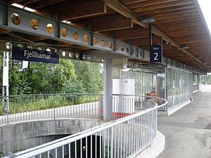
Fjellhamar Station
Distance: Approx. 1741 meters
Latitude and longitude: 59.94083333,10.98166667
Fjellhamar is a railway station on the Trunk Line in Lørenskog, Norway. It is served by the Oslo Commuter Rail line L1 operated by Vy running from Lillestrøm via Oslo S to Spikkestad. The station was opened in 1931, but the current station was built from scratch in 2003.

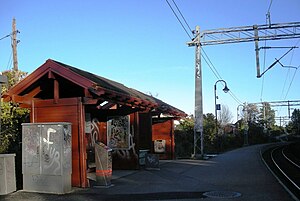
Strømmen Station
Distance: Approx. 653 meters
Latitude and longitude: 59.95027778,11.0025
Strømmen Station (Norwegian: Strømmen stasjon) is a railway station on the Trunk Line in Skedsmo, Norway. It is served by the Oslo Commuter Rail line L1 operated by Vy running from Lillestrøm via Oslo S to Spikkestad. The station was opened in 1854 along with the rest of the Trunk Line.
Sagdalen Station
Distance: Approx. 1198 meters
Latitude and longitude: 59.95611111,11.01666667
Sagdalen Station (Norwegian: Sagdalen stasjon) is a railway station on the Trunk Line in Skedsmo, Norway. It is served by the Oslo Commuter Rail line L1 operated by Vy running from Lillestrøm via Oslo S to Spikkestad. The station was opened in 1938.
Strømmen
Town in Akershus, Norway
Distance: Approx. 605 meters
Latitude and longitude: 59.95,11
Strømmen is a town in Lillestrøm municipality, Akershus county, Norway. It is about twenty kilometers east of Oslo, and considered part of Greater Oslo. It has around 11,400 residents.
Fjellhamar
Village in Østlandet, Norway
Distance: Approx. 1229 meters
Latitude and longitude: 59.945,10.98555556
Fjellhamar is a village in Lørenskog, Akershus, Norway, and it is about twenty minutes driving from Oslo.
Hvam, Skedsmo
Village in Østlandet, Norway
Distance: Approx. 2164 meters
Latitude and longitude: 59.9743,10.9978
Hvam is a village in Lillestrøm, Akershus, Norway.
Nordbyhagen
Village in Østlandet, Norway
Distance: Approx. 2406 meters
Latitude and longitude: 59.9333,10.9936
Nordbyhagen is a village in Akershus, Norway. The area is home to Akershus University Hospital (sometimes referred to as "Ahus").

Skjetten
Village in Østlandet, Norway
Distance: Approx. 2043 meters
Latitude and longitude: 59.97277778,11.00361111
Skjetten is a town in Lillestrøm municipality, Akershus county, Norway. It is located approximately 20 kilometres northeast of Oslo's city centre with a population of 10 000. Skjetten has five kindergartens, two primary schools and a secondary school in close proximity.

Romerike og Glåmdal District Court
Distance: Approx. 2377 meters
Latitude and longitude: 59.9550971,11.03793907
Romerike og Glåmdal District Court (Norwegian: Romerike og Glåmdal tingrett) is a district court located in Innlandet and Akershus counties in Norway. This court is based at three different courthouses which are located in Eidsvoll, Kongsvinger, and Lillestrøm. The court serves the southern part of Innlandet county and the northern part of Akershus county.
Weather in this IP's area
scattered clouds
10 Celsius
10 Celsius
9 Celsius
11 Celsius
1029 hPa
96 %
1029 hPa
1005 hPa
10000 meters
0.24 m/s
0.24 m/s
137 degree
50 %
06:49:19
19:31:43