Country:
 Lithuania
Region:
City:
Latitude and Longitude:
Time Zone:
Postal Code:
IP information under different IP Channel
ip-api
Country
Region
City
ASN
Time Zone
ISP
Blacklist
Proxy
Latitude
Longitude
Postal
Route
IPinfo
Country
Region
City
ASN
Time Zone
ISP
Blacklist
Proxy
Latitude
Longitude
Postal
Route
MaxMind
Country
Region
City
ASN
Time Zone
ISP
Blacklist
Proxy
Latitude
Longitude
Postal
Route
Luminati
Country
LTRegion
kl
City
klaipeda
ASN
Time Zone
Europe/Vilnius
ISP
UAB Cgates
Latitude
Longitude
Postal
db-ip
Country
Region
City
ASN
Time Zone
ISP
Blacklist
Proxy
Latitude
Longitude
Postal
Route
ipdata
Country
Region
City
ASN
Time Zone
ISP
Blacklist
Proxy
Latitude
Longitude
Postal
Route
Popular places and events near this IP address

Klaipėda
Coastal city in Lithuania
Distance: Approx. 1549 meters
Latitude and longitude: 55.7125,21.135
Klaipėda ( CLAY-ped-ə; Lithuanian: [ˈkɫɐɪpʲeːdɐ] ; German: Memel) is a city in Lithuania on the Baltic Sea coast. It is the third largest city in Lithuania, the fifth largest city in the Baltic States and the capital of Klaipėda County, as well as the only major seaport in the country. The city has a complex recorded history, partially due to the combined regional importance of the usually ice-free Port of Klaipėda at the mouth of the river Akmena-Danė.

Smiltynė
Distance: Approx. 1079 meters
Latitude and longitude: 55.70611111,21.11111111
Smiltynė (German: Sandkrug) is a part of Klaipėda city municipality in Lithuania. It is located on the northern tip of the Curonian Spit, next to Kopgalis, which is at the very tip of the spit pointing into the narrow strait which connects the Curonian Lagoon to the Baltic Sea. Across the 0.5-kilometre wide (0.31 mi) strait, on the Lithuanian mainland, is the port city of Klaipėda.
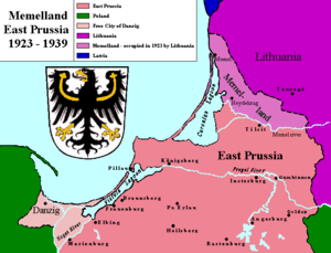
Klaipėda Revolt
1923 successful push for unification with Lithuania in the Klaipėda Region of East Prussia
Distance: Approx. 1549 meters
Latitude and longitude: 55.7125,21.135
The Klaipėda Revolt took place in January 1923 in the Klaipėda Region (also known as the Memel Territory or Memelland). The region, located north of the Neman River, was detached from East Prussia, German Empire by the Treaty of Versailles and became a mandate of the League of Nations. It was placed under provisional French administration until a more permanent solution could be worked out.

Klaipėda Central Stadium
Lithuanian football stadium
Distance: Approx. 1161 meters
Latitude and longitude: 55.7262,21.1096
Klaipėda Central Stadium (Lithuanian: Klaipėdos centrinis stadionas) is a football stadium in Klaipėda, Lithuania. It was the home ground of FK Atlantas, and has a capacity of 4,428. The construction started in 1925 and the stadium was originally opened in 1927.
Klaipėda University
University in Lithuania
Distance: Approx. 1265 meters
Latitude and longitude: 55.72459167,21.12378889
Klaipėda University (Lithuanian: Klaipėdos universitetas or KU) is a university in the Lithuanian port city of Klaipėda.

Port of Klaipėda
Port in Lithuania
Distance: Approx. 239 meters
Latitude and longitude: 55.717778,21.1125
The Port of Klaipėda (Lithuanian: Klaipėdos uostas) is a seaport located in Klaipėda, Lithuania. It is one of the few ice-free ports in northernmost Europe, and the second largest European Union port by tonnage in the Baltic. It serves as a port of call for cruise ships as well as freight transport.
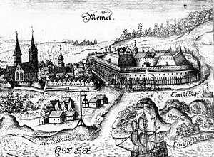
Klaipėda Castle
Distance: Approx. 1600 meters
Latitude and longitude: 55.70555556,21.12888889
Klaipėda Castle (Lithuanian: Klaipėdos pilis), also known as Memelburg or Memel Castle, is an archeological site and museum housed in a castle built by the Teutonic Knights in Klaipėda, Lithuania, near the Baltic Sea. The Teutons called the castle Memelburg or Memel, and Klaipėda was generally known as Memel until 1923, when Lithuanian military forces took over the city. The castle was first mentioned in written sources in 1252, and underwent numerous destructions and reconstructions in the centuries that followed.

Institute of Baltic Region History and Archaeology
Research institute of Klaipėda University
Distance: Approx. 1257 meters
Latitude and longitude: 55.72444444,21.12388889
Institute of Baltic Region History and Archaeology (Lithuanian: Baltijos regiono istorijos ir archeologijos institutas or BRIAI) is the scholarly research subdivision of Klaipėda University. It was established in 2003, following reorganization of the former Centre for the History of Western Lithuania and Prussia, which functioned in the period 1992 to 2003 The scholars of the Institute are involved in the research of changes in prehistoric and historic societies and cultures within the Baltic region by applying diverse scientific theories and methodologies.

LKL Sūduvis (M52)
Distance: Approx. 1377 meters
Latitude and longitude: 55.708918,21.129246
LKL Sūduvis (M52) is a minehunter of the Lithuanian Naval Force. Built in West Germany in 1957 as Koblenz (M1071), a Lindau-class (or Type 320) minesweeper for the German Navy, she was upgraded to a Type 331 minehunter in the 1970s. Germany donated Koblenz to the Lithuanian Naval Force in 1999.

Klaipėda railway station
Railway station in Klaipėda, Lithuania
Distance: Approx. 1589 meters
Latitude and longitude: 55.72083333,21.13472222
Klaipėda railway station (Lithuanian: Klaipėdos geležinkelio stotis) is a Lithuanian Railways station in Klaipėda. It is located at the northern part of the old town of the city. The current building was built in 1983.
Battle of Memel (1323)
Distance: Approx. 1525 meters
Latitude and longitude: 55.706,21.128
The Battle of Memel was fought between the Samogitians and the Livonian branch of the Teutonic Knights in 1323. According to the chronicle of Peter of Dusburg, the Samogitians burned the city, but failed to take the Memel Castle. They also burned another three neighboring castles probably Žardė (now the southern outskirts of Klaipėda), Poyso (on the left bank of upstream Dangė River, east of Klaipėda), and Eketė (at the confluence of Dangė and Eketė Rivers).

Arka (monument)
Distance: Approx. 1517 meters
Latitude and longitude: 55.71055556,21.13333333
Arka (transl. Arch) is a monument in Klaipėda, Lithuania. Unveiled on 8 August 2003, it commemorates the 85-year anniversary of the Act of Tilsit and the 80-year anniversary of the Klaipėda Revolt. The monument weighs 150 tonnes and reaches 8.5 metres (28 ft) in height.
Weather in this IP's area
broken clouds
16 Celsius
15 Celsius
16 Celsius
16 Celsius
1020 hPa
56 %
1020 hPa
1020 hPa
10000 meters
7.19 m/s
10.91 m/s
128 degree
62 %
06:54:33
20:12:08