Country:
 Great Britain
Region:
City:
Latitude and Longitude:
Time Zone:
Postal Code:
IP information under different IP Channel
ip-api
Country
Region
City
ASN
Time Zone
ISP
Blacklist
Proxy
Latitude
Longitude
Postal
Route
IPinfo
Country
Region
City
ASN
Time Zone
ISP
Blacklist
Proxy
Latitude
Longitude
Postal
Route
MaxMind
Country
Region
City
ASN
Time Zone
ISP
Blacklist
Proxy
Latitude
Longitude
Postal
Route
Luminati
Country
GBASN
Time Zone
Europe/London
ISP
CloudCoCo Connect Limited
Latitude
Longitude
Postal
db-ip
Country
Region
City
ASN
Time Zone
ISP
Blacklist
Proxy
Latitude
Longitude
Postal
Route
ipdata
Country
Region
City
ASN
Time Zone
ISP
Blacklist
Proxy
Latitude
Longitude
Postal
Route
Popular places and events near this IP address

Daresbury
Human settlement in England
Distance: Approx. 962 meters
Latitude and longitude: 53.3402,-2.6332
Daresbury is a village and civil parish in the Borough of Halton, Cheshire, England. At the 2011 census, it had a population of 246.
Creamfields
English annual dance music festival held in Cheshire
Distance: Approx. 749 meters
Latitude and longitude: 53.34,-2.63
Creamfields is an electronic dance music festival series founded and organised by British club promoter Cream, with its UK edition taking place on August Bank Holiday weekend, with a number of international editions held across various territories worldwide. First held in 1998 in Winchester, the festival moved to Cream's home city of Liverpool the following year, taking place on the old Liverpool airport, before moving to its current location on the Daresbury estate in Cheshire. The festival, having initially begun as a one-day event with 25,000 people in attendance, is now a four-day event with camping options hosting 70,000 per day.

Hatton, Warrington
Human settlement in England
Distance: Approx. 994 meters
Latitude and longitude: 53.338,-2.604
Hatton is a civil parish and hamlet in the Borough of Warrington, Cheshire, England, located to the south of Warrington town centre. It lies on the B5356 road between the villages of Daresbury and Stretton. It has one public house, The Hatton Arms.

Cockcroft Institute
Distance: Approx. 1409 meters
Latitude and longitude: 53.34472222,-2.63777778
The Cockcroft Institute is an international centre for Accelerator Science and Technology (AST) in the UK. It was proposed in September 2003 and officially opened in September 2006. It is a joint venture of Lancaster University, the University of Liverpool, the University of Manchester, the University of Strathclyde, the Science and Technology Facilities Council, and the Northwest Regional Development Agency. The Institute is located in a purpose-built building on the Sci-Tech Daresbury campus, and in centres in each of the participating universities.
Daresbury Laboratory
Laboratory in Halton, Cheshire, UK
Distance: Approx. 1511 meters
Latitude and longitude: 53.34305556,-2.64055556
Daresbury Laboratory is a scientific research laboratory based at Sci-Tech Daresbury campus near Daresbury in Halton, Cheshire, England. The laboratory began operations in 1962 and was officially opened on 16 June 1967 as the Daresbury Nuclear Physics Laboratory (DNPL) by the then Prime Minister of United Kingdom, Harold Wilson. It was the second national laboratory established by the British National Institute for Research in Nuclear Science, following the Rutherford High Energy Laboratory (now Rutherford Appleton Laboratory).
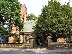
All Saints' Church, Daresbury
Church in Cheshire, England
Distance: Approx. 839 meters
Latitude and longitude: 53.3406,-2.6312
All Saints' Church is in the village of Daresbury, Cheshire, England. It is known for its association with Lewis Carroll who is commemorated in its stained glass windows depicting characters from Alice's Adventures in Wonderland. It is recorded in the National Heritage List for England as a designated Grade II* listed building.
EMMA (accelerator)
Distance: Approx. 1511 meters
Latitude and longitude: 53.34305556,-2.64055556
The electron machine with many applications or electron model for many applications (EMMA) is a linear non-scaling FFAG (fixed-field alternating-gradient) particle accelerator at Daresbury Laboratory in the UK that can accelerate electrons from 10 to 20 MeV. A FFAG is a type of accelerator in which the magnetic field in the bending magnets is constant during acceleration. This means the particle beam will move radially outwards as its momentum increases. Acceleration was successfully demonstrated in EMMA, paving the way for future non-scaling FFAGs to meet important applications in energy, security and medicine.

HPCx
Distance: Approx. 1511 meters
Latitude and longitude: 53.34305556,-2.64055556
HPCx was a supercomputer (actually a cluster of IBM eServer p5 575 high-performance servers) located at the Daresbury Laboratory in Cheshire, England.
NINA (accelerator)
Particle accelerator
Distance: Approx. 1511 meters
Latitude and longitude: 53.34305556,-2.64055556
NINA (Northern Institute's Nuclear Accelerator) was a particle accelerator located at Daresbury Laboratory, UK that was used for particle physics and as a source of synchrotron radiation.

Daresbury Hall
Distance: Approx. 472 meters
Latitude and longitude: 53.33798,-2.62575
Daresbury Hall is a former Georgian country house in the village of Daresbury, Cheshire, England. It was built in 1759 for George Heron. The house is recorded in the National Heritage List for England as a designated Grade II* listed building.
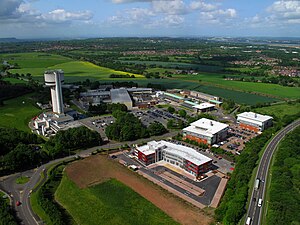
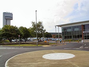
Sci-Tech Daresbury
Distance: Approx. 1506 meters
Latitude and longitude: 53.343,-2.6405
Sci-Tech Daresbury, also known as Sci-Tech Daresbury Enterprise Zone, is a science and innovation campus near the village of Daresbury in Halton, Cheshire, England. The site began life as the Daresbury Laboratory later forming a joint venture and adding the Cockcroft Institute, Innovation Centre, Vanguard House, Techspace One and ITAC. Over 1,300 people work on the campus for nearly 150 high tech companies. The science park was formerly known as Daresbury Science and Innovation Campus.
Hartree Centre
Distance: Approx. 1435 meters
Latitude and longitude: 53.3446,-2.6383
The Hartree Centre is a high performance computing, data analytics and artificial intelligence (AI) research facility focused on industry-led challenges. It was formed in 2012 at Daresbury Laboratory on the Sci-Tech Daresbury science and innovation campus in Cheshire, UK. The Hartree Centre is part of the Science and Technology Facilities Council (STFC) which itself is part of United Kingdom Research and Innovation (UKRI).
Weather in this IP's area
fog
11 Celsius
10 Celsius
9 Celsius
12 Celsius
1028 hPa
97 %
1028 hPa
1021 hPa
200 meters
2.06 m/s
160 degree
100 %
06:46:26
19:24:13