81.25.84.76 - IP Lookup: Free IP Address Lookup, Postal Code Lookup, IP Location Lookup, IP ASN, Public IP
Country:
 Sweden
Region:
City:
Location:
Time Zone:
Postal Code:
ISP:
ASN:
language:
User-Agent:
Proxy IP:
Blacklist:
IP information under different IP Channel
ip-api
Country
Region
City
ASN
Time Zone
ISP
Blacklist
Proxy
Latitude
Longitude
Postal
Route
db-ip
Country
Region
City
ASN
Time Zone
ISP
Blacklist
Proxy
Latitude
Longitude
Postal
Route
IPinfo
Country
Region
City
ASN
Time Zone
ISP
Blacklist
Proxy
Latitude
Longitude
Postal
Route
IP2Location
81.25.84.76Country
seRegion
vasternorrlands lan
City
timra
Time Zone
Europe/Stockholm
ISP
Language
User-Agent
Latitude
Longitude
Postal
ipdata
Country
Region
City
ASN
Time Zone
ISP
Blacklist
Proxy
Latitude
Longitude
Postal
Route
Popular places and events near this IP address

Timrå Municipality
Municipality in Västernorrland County, Sweden
Distance: Approx. 1499 meters
Latitude and longitude: 62.5,17.33333333
Timrå Municipality (Timrå kommun) is a municipality in Västernorrland County, Sweden. The town of Timrå is the municipal seat. The rural municipality Timrå was made a market town (köping) in 1947.

Timrå
Place in Medelpad, Sweden
Distance: Approx. 9 meters
Latitude and longitude: 62.48694444,17.32583333
Timrå () is a locality and the seat of Timrå Municipality in Västernorrland County, Sweden with 10,443 inhabitants in 2010. It is located about 13 km north of Sundsvall (a town with a metropolitan area of some 100,000 inhabitants), and could arguably be considered a satellite to that town. The two closest cities (Sundsvall and Härnösand) share one airport, Midlanda, that is geographically located in Timrå.

Sörberge
Distance: Approx. 3917 meters
Latitude and longitude: 62.51666667,17.36666667
Sörberge is a village in Timrå Municipality, Sweden. The village has three schools, Böle skola for years 1–6, Sörbergeskolan for years 7–9, and Timrå Gymnasieskola for the secondary school level. The local Ice hockey team, Timrå Red Eagles, plays its home hames in the SCA Arena located between Sörbergskolan and Timrå Secondary School.

Indalsälven
River in Sweden
Distance: Approx. 5720 meters
Latitude and longitude: 62.5,17.43333333
Indalsälven is one of Sweden's longest rivers with a total length of 430 kilometers. Among its tributaries are Kallströmmen, Långan, Hårkan and Ammerån. A total of 26 hydropower plants are placed along its course, making it the third most power producing river of Sweden.
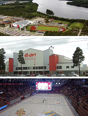
Timrå Isstadion
Indoor sporting arena in Timrå, Sweden
Distance: Approx. 2440 meters
Latitude and longitude: 62.50583333,17.35
Timrå Isstadion, currently known as SCA Arena and formerly known as NHC Arena, NHK Arena, E.ON Arena, Sydkraft Arena for sponsorship reasons, is an indoor sporting arena located in Timrå, Västernorrland County, Sweden. Construction began in 1964 and was inaugurated on 4 September 1966. Since then the venue has undergone several renovations and expansions.

Bergeforsen
Place in Medelpad, Sweden
Distance: Approx. 4436 meters
Latitude and longitude: 62.51666667,17.38333333
Bergeforsen is a locality situated in Timrå Municipality, Västernorrland County, Sweden with 1,563 inhabitants in 2010.
Vi, Sweden
Place in Medelpad, Sweden
Distance: Approx. 7590 meters
Latitude and longitude: 62.43333333,17.41666667
Vi is a locality situated on Alnön in Sundsvall Municipality, Västernorrland County, Sweden with 4,997 inhabitants in 2010.
Hovid
Place in Medelpad, Sweden
Distance: Approx. 3730 meters
Latitude and longitude: 62.46666667,17.38333333
Hovid is a locality situated in Sundsvall Municipality, Västernorrland County, Sweden with 225 inhabitants in 2010.
Johannedal
Place in Medelpad, Sweden
Distance: Approx. 6335 meters
Latitude and longitude: 62.43333333,17.36666667
Johannedal is a locality situated in Sundsvall Municipality, Västernorrland County, Sweden with 2,754 inhabitants in 2010.
Sundsbruk
Place in Medelpad, Sweden
Distance: Approx. 4304 meters
Latitude and longitude: 62.45,17.35
Sundsbruk is a locality situated in Sundsvall Municipality, Västernorrland County, Sweden with 2,137 inhabitants in 2010.

Timrå Church
Church in Timrå, Sweden
Distance: Approx. 1304 meters
Latitude and longitude: 62.4763,17.3154
The Timrå Church (Swedish: Timrå kyrka) is a church building in Östrand in Timrå, Sweden. Belonging to the Timrå Parish of the Church of Sweden, it was inaugurated on 16 October 1796.

Alnön old church
Church building in Sundsvall Municipality, Sweden
Distance: Approx. 5990 meters
Latitude and longitude: 62.44767,17.40514
Alnön's old church (Swedish: Alnö gamla kyrka) is a medieval church on the island of Alnön, Sundsvall Municipality, Sweden. The oldest part of the church probably originates from the 13th century. The church is mentioned in 1314 as subordinate to Skön, and Alnön became its own pastorate only in 1892.
Weather in this IP's area
clear sky
-10 Celsius
-10 Celsius
-10 Celsius
-10 Celsius
1032 hPa
92 %
1032 hPa
1018 hPa
10000 meters
0.51 m/s
6 %