Country:
 Netherlands
Region:
City:
Latitude and Longitude:
Time Zone:
Postal Code:
IP information under different IP Channel
ip-api
Country
Region
City
ASN
Time Zone
ISP
Blacklist
Proxy
Latitude
Longitude
Postal
Route
IPinfo
Country
Region
City
ASN
Time Zone
ISP
Blacklist
Proxy
Latitude
Longitude
Postal
Route
MaxMind
Country
Region
City
ASN
Time Zone
ISP
Blacklist
Proxy
Latitude
Longitude
Postal
Route
Luminati
Country
NLASN
Time Zone
Europe/Amsterdam
ISP
Cyso Group B.V.
Latitude
Longitude
Postal
db-ip
Country
Region
City
ASN
Time Zone
ISP
Blacklist
Proxy
Latitude
Longitude
Postal
Route
ipdata
Country
Region
City
ASN
Time Zone
ISP
Blacklist
Proxy
Latitude
Longitude
Postal
Route
Popular places and events near this IP address

Alkmaar
City and municipality in North Holland, Netherlands
Distance: Approx. 1097 meters
Latitude and longitude: 52.63333333,4.75
Alkmaar (Dutch pronunciation: [ˈɑl(ə)kmaːr] ) is a city and municipality in the Netherlands, located in the province of North Holland. Alkmaar is well known for its traditional cheese market. For tourists, it is a popular cultural destination.
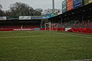
Alkmaarderhout (stadium)
Distance: Approx. 1942 meters
Latitude and longitude: 52.62111111,4.73111111
The Alkmaarderhout is a football stadium in Alkmaarderhout, a city park in Alkmaar, North Holland, Netherlands. It was used from 1948 until 2006, when it was replaced by the AFAS Stadion. The Alkmaarderhout was the home ground of Eredivisie side AZ Alkmaar.

Siege of Alkmaar
1573 battle of the Eighty Years' War
Distance: Approx. 1323 meters
Latitude and longitude: 52.63,4.75
The siege of Alkmaar (1573) was a turning point in the Eighty Years' War. The burghers of the Dutch city of Alkmaar held off the Spanish (who had set up their camp in Oudorp) between 21 August and 8 October 1573, with boiling tar and burning branches from their renewed city walls. On 23 September William the Silent followed up on a request by Cabeliau dating from the beginning of the siege and ordered the dikes surrounding Alkmaar to be breached, thereby flooding the polders in which the Spanish troops were camped, like the Achtermeer polder.
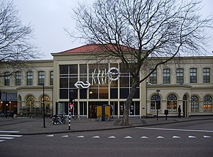
Alkmaar railway station
Station in the Netherlands
Distance: Approx. 315 meters
Latitude and longitude: 52.63777778,4.74055556
Alkmaar railway station serves the town of Alkmaar, Netherlands. It is located approximately 40 km (25 mi) northwest of Amsterdam. The station opened on 20 December 1865 and is located on the Den Helder–Amsterdam railway.

Battle of Alkmaar (1799)
Battle of the War of the Second Coalition
Distance: Approx. 824 meters
Latitude and longitude: 52.63444444,4.74638889
The Battle of Alkmaar (also sometimes called the Second Battle of Bergen or the Battle of Egmond-aan-Zee) was fought on 2 October 1799 between forces of the French Republic and her ally, the Batavian Republic under the command of general Guillaume Marie Anne Brune, and an expeditionary force from Great Britain and her ally Russia, commanded by Prince Frederick, Duke of York and Albany in the vicinity of Alkmaar during the Anglo-Russian invasion of Holland. The battle ended in a Anglo-Russians victory, forcing Brune to order a strategic withdrawal the next day to a line between Monnickendam in the East and Castricum in the West. There the final battle of the campaign would take place on 6 October.
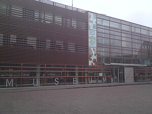
Stedelijk Museum Alkmaar
Distance: Approx. 750 meters
Latitude and longitude: 52.6334,4.7436
Stedelijk Museum Alkmaar is a city museum located in the center of Alkmaar on the Canadaplein (Canada Square). The museum is devoted to presenting and preserving the cultural history of Alkmaar and the surrounding region.

Grote or Sint-Laurenskerk (Alkmaar)
Distance: Approx. 838 meters
Latitude and longitude: 52.6325,4.74388889
Grote or Sint-Laurenskerk (English: Great, or St. Lawrence church) is a landmark formerly Protestant church in Alkmaar, Netherlands, now in secular use. The building is located on the Koorstraat (choir street).
Sportpaleis Alkmaar
Distance: Approx. 1369 meters
Latitude and longitude: 52.6347,4.7166
The Sportpaleis Alkmaar is a velodrome and multisport indoor arena in Alkmaar, the Netherlands. The original velodrome, which was built in 1964 and made of concrete, was renovated in 2003. The concrete track was replaced by a wooden track and was now situated in a completely covered hall.
Rôtisserie Rue du Bois
Restaurant in Alkmaar, Netherlands
Distance: Approx. 1030 meters
Latitude and longitude: 52.63203333,4.74719167
Rôtisserie Rue du Bois is a defunct restaurant in Alkmaar, Netherlands. It was a fine dining restaurant that was awarded one Michelin star in 1979. The restaurant lost its star the next year, after the departure of the head chef.
Alcmaria Victrix
Dutch sport club
Distance: Approx. 1743 meters
Latitude and longitude: 52.62907222,4.71513056
Alcmaria Victrix is a Dutch omnisport club based in Alkmaar. The club has football, baseball and softball departments. The name is derived from the city crest "Wapen van Alkmaar", Alcmaria Victrix as in Alkmaar as victor.

Waag (Alkmaar)
Listed building in Netherlands, site of annual cheese market
Distance: Approx. 1235 meters
Latitude and longitude: 52.6314,4.7503
The Waag building is a National monument (Rijksmonument) listed building on the Waagplein in Alkmaar in the Netherlands. On this square Waagplein every Friday from April till the second week of September, the famous cheese market is held. The Dutch Cheese Museum and the tourist information Office (VVV) are also in the building.
Alkmaarderhout
Park in Alkmaar
Distance: Approx. 1477 meters
Latitude and longitude: 52.625158,4.732928
Alkmaarderhout, locally known as "De Hout" (Dutch for "the wood(s)"), in a city park in Alkmaar, North Holland, Netherlands. The park is one of the oldest city parks in the Netherlands, dating from 1607.
Weather in this IP's area
clear sky
7 Celsius
4 Celsius
6 Celsius
8 Celsius
1021 hPa
93 %
1021 hPa
1021 hPa
10000 meters
3.24 m/s
4.82 m/s
102 degree
6 %
08:07:02
18:46:09