81.201.164.22 - IP Lookup: Free IP Address Lookup, Postal Code Lookup, IP Location Lookup, IP ASN, Public IP
Country:
Region:
City:
Location:
Time Zone:
Postal Code:
IP information under different IP Channel
ip-api
Country
Region
City
ASN
Time Zone
ISP
Blacklist
Proxy
Latitude
Longitude
Postal
Route
Luminati
Country
Region
eng
ASN
Time Zone
Europe/London
ISP
London Stock Exchange PLC
Latitude
Longitude
Postal
IPinfo
Country
Region
City
ASN
Time Zone
ISP
Blacklist
Proxy
Latitude
Longitude
Postal
Route
IP2Location
81.201.164.22Country
Region
england
City
fitzwilliam
Time Zone
Europe/London
ISP
Language
User-Agent
Latitude
Longitude
Postal
db-ip
Country
Region
City
ASN
Time Zone
ISP
Blacklist
Proxy
Latitude
Longitude
Postal
Route
ipdata
Country
Region
City
ASN
Time Zone
ISP
Blacklist
Proxy
Latitude
Longitude
Postal
Route
Popular places and events near this IP address

Nostell
Village in West Yorkshire, England
Distance: Approx. 1844 meters
Latitude and longitude: 53.646,-1.394
Nostell is a village in the City of Wakefield in West Yorkshire, England, near Hemsworth. It is in the civil parish of Huntwick with Foulby and Nostell, which had a population of 90 in 2001, and 164 at the 2011 census (including Wintersett). Nostell Priory is an 18th-century Palladian historic house, on the site of an Augustinian priory which received its charter in 1121.

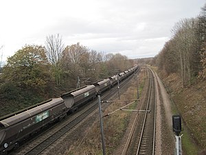
Fitzwilliam railway station
Railway station in West Yorkshire, England
Distance: Approx. 162 meters
Latitude and longitude: 53.6326,-1.3745
Fitzwilliam railway station is in the small village of Fitzwilliam, West Yorkshire, England. It is also the closest station to the nearby town of Hemsworth. The station is on the Wakefield Line operated by Northern.
Fitzwilliam, West Yorkshire
Village in West Yorkshire, England
Distance: Approx. 100 meters
Latitude and longitude: 53.63249,-1.37556
Fitzwilliam is a small village on the edge of West Yorkshire, England, in the City of Wakefield district. The village falls within the Hemsworth ward of Wakefield City Council.

Brackenhill
Village in West Yorkshire, England
Distance: Approx. 1711 meters
Latitude and longitude: 53.642,-1.356
Brackenhill is a village in West Yorkshire, England, which forms part of Ackworth parish. It is situated on the A638 road on the eastern bank of Hessle Beck, west of Ackworth Moor Top and north of Fitzwilliam Country Park. A major industry in Brackenhill was quarrying, and at the end of the 19th century the majority of the male inhabitants of the village were occupied in the quarries.

Kinsley, West Yorkshire
Village in West Yorkshire, England
Distance: Approx. 893 meters
Latitude and longitude: 53.626,-1.37
Kinsley is a village in the civil parish of Hemsworth, and the City of Wakefield district of West Yorkshire, England. Kinsley is a rural, ex-mining village. Its neighbouring villages are Fitzwilliam to the north, to which it is conjoined, and Hemsworth to the south-east.

Kinsley Greyhound Stadium
Distance: Approx. 976 meters
Latitude and longitude: 53.625975,-1.36784444
Kinsley Greyhound Stadium is a Greyhound Board of Great Britain regulated greyhound racing stadium situated in Kinsley, West Yorkshire, England.
Hemsworth Miners Welfare F.C.
Association football club in England
Distance: Approx. 352 meters
Latitude and longitude: 53.63592778,-1.37535
Hemsworth Miners Welfare Football Club is a football club based in Hemsworth, West Yorkshire, England. They are currently members of the Sheffield & Hallamshire County Senior League Premier Division and play at the Just Football MDC Stadium in Fitzwilliam.

Nostell railway station
Disused railway station in West Yorkshire, England
Distance: Approx. 1812 meters
Latitude and longitude: 53.6428,-1.3987
Nostell railway station served the village of Nostell, West Yorkshire, England from 1866 to 1951 on the West Riding and Grimsby Railway.

Hemsworth railway station
Disused railway station in West Yorkshire, England
Distance: Approx. 2446 meters
Latitude and longitude: 53.6193,-1.3478
Hemsworth railway station served the town of Hemsworth, West Yorkshire, England from 1866 to 1967 on the West Riding and Grimsby Railway.
Wakefield City Academies Trust
Multi-academy trust
Distance: Approx. 2017 meters
Latitude and longitude: 53.65,-1.387
Wakefield City Academies Trust (WCAT) was a multi-academy trust (MAT) that managed 21 schools (14 primary and 7 secondary) across West Yorkshire, South Yorkshire, and the East Riding of Yorkshire. As an academy trust, it was an exempt charity regulated by the Department for Education (DfE). In September 2017, WCAT announced it would cease operations and dissolve once new sponsor organisations were found for its schools.

Normanton and Hemsworth (UK Parliament constituency)
Parliamentary constituency in the United Kingdom, 2024 onwards
Distance: Approx. 1915 meters
Latitude and longitude: 53.65,-1.38
Normanton and Hemsworth is a constituency of the House of Commons in the UK Parliament. Created as a result of the 2023 Periodic Review of Westminster constituencies, it was first contested at the 2024 general election. It is currently represented by Jon Tickett of the Labour Party, who previously represented the predecessor constituency of Hemsworth from 1996 to 2024.

Wragby, West Yorkshire
Hamlet in West Yorkshire, England
Distance: Approx. 1783 meters
Latitude and longitude: 53.6488,-1.3802
Wragby is a hamlet and former parish in the City of Wakefield district, West Yorkshire, England. It is in the civil parish of Hessle and Hill Top, although on the border of Huntwick with Foulby and Nostell. The village is on the A638 road from Wakefield to Doncaster, immediately east of the National Trust property of Nostell Priory.
Weather in this IP's area
scattered clouds
4 Celsius
4 Celsius
4 Celsius
5 Celsius
1038 hPa
83 %
1038 hPa
1029 hPa
10000 meters
0.97 m/s
1.36 m/s
185 degree
44 %