Country:
 Russian Federation
Region:
City:
Latitude and Longitude:
Time Zone:
Postal Code:
IP information under different IP Channel
ip-api
Country
Region
City
ASN
Time Zone
ISP
Blacklist
Proxy
Latitude
Longitude
Postal
Route
IPinfo
Country
Region
City
ASN
Time Zone
ISP
Blacklist
Proxy
Latitude
Longitude
Postal
Route
MaxMind
Country
Region
City
ASN
Time Zone
ISP
Blacklist
Proxy
Latitude
Longitude
Postal
Route
Luminati
Country
RUASN
Time Zone
Europe/Moscow
ISP
Rostelecom
Latitude
Longitude
Postal
db-ip
Country
Region
City
ASN
Time Zone
ISP
Blacklist
Proxy
Latitude
Longitude
Postal
Route
ipdata
Country
Region
City
ASN
Time Zone
ISP
Blacklist
Proxy
Latitude
Longitude
Postal
Route
Popular places and events near this IP address

Vladivostok State University of Economics and Service
University in Vladivostok, Russia
Distance: Approx. 1230 meters
Latitude and longitude: 43.1256,131.905
Vladivostok State University of Economics and Service (Russian: Владивосто́кский госуда́рственный университе́т эконо́мики и се́рвиса), or VSUES (ВГУЭС), is a university located in Vladivostok, Russia. Over 17 000 students from Russia and abroad study at VSUES. It has 68 bachelor's programs, 20 master's programs, 22 Ph.D. programs, and 8 technical programs. Programs are in areas as diverse as economics and business, design, management, tourism, engineering, and international studies.

Primorskaya Oblast
Former Russian administrative division
Distance: Approx. 980 meters
Latitude and longitude: 43.1167,131.9
Primorskaya Oblast (Russian: Примо́рская о́бласть) was an administrative division of the Russian Empire and the early Russian SFSR, created on October 31, 1856 by the Governing Senate. The name of the region literally means "Maritime" or "Coastal." The region was established upon a Russian conquest of Daur people that used to live along Amur River. Before the Russian conquest of Russian Manchuria, the territory belonged to the Chinese region of Manchuria.
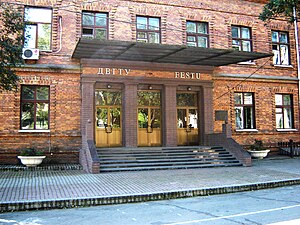
Far Eastern State Technical University
University in Russia
Distance: Approx. 886 meters
Latitude and longitude: 43.1156,131.9011
Far Eastern State Technical University (FESTU) (Russian: Дальневосто́чный госуда́рственный техни́ческий университе́т, ДВГТУ) is a university located in Vladivostok, Russia. It was established on February 20, 1930 as Far Eastern Politechnical Institute (Дальневосточный политехнический институт (ДВПИ)). It was granted the university status in 1992.

Zolotoy Rog
Bay in Russia
Distance: Approx. 1369 meters
Latitude and longitude: 43.10833333,131.89861111
Zolotoy Rog (Russian: Золотой Рог) or the Golden Horn Bay, is a sheltered horn-shaped bay of the Sea of Japan, located in coastal Primorsky Krai within the Russian Far East. Vladivostok, which lies on the hills at the head of the bay, is a major city and Russian port on the Pacific.
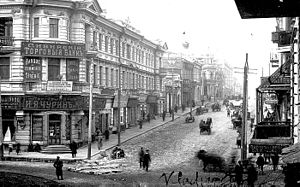
Svetlanskaya Street
Street in Vladivostok, Russia
Distance: Approx. 530 meters
Latitude and longitude: 43.1125,131.9167
Svetlanskaya Street (Russian: Светла́нская у́лица, romanized: Svetlanskaya ulitsa) is a major street in Vladivostok, Russia.

Zolotoy Bridge
Bridge in Vladivostok, Russia
Distance: Approx. 1499 meters
Latitude and longitude: 43.10902,131.896058
The Zolotoy Bridge (Russian: Золотой мост, lit. 'Golden Bridge') is a cable-stayed bridge across the Zolotoy Rog (Golden Horn Bay) in Vladivostok, Russia. The Zolotoy Rog Bridge was one of two bridges, along with the Russky Island Bridge, built in preparation for the 2012 APEC summit. The bridge was commissioned by the city of Vladivostok in 2006.
Eagle's Nest Hill
Distance: Approx. 1387 meters
Latitude and longitude: 43.12083333,131.89638889
Eagle's Nest Hill (Russian: Орлиное Гнездо) is a hill in the Russian city of Vladivostok. Previously called Klykova, the peak was renamed in honour of the Russian troops who fought at Mt. St Nicholas in the Shipka Pass during the Russo-Turkish war of 1878.

Mother of God Church, Vladivostok
Church in Vladivostok, Russia
Distance: Approx. 83 meters
Latitude and longitude: 43.1164,131.9114
The Mother of God Church (Russian: Церковь Пресвятой Богородицы) It is a Latin Catholic church, built in a Gothic style, located in Vladivostok in the Far East of Russia. It is the seat of the deanery of Vladivostok, which depends on the Diocese of Irkutsk. It is located at 22 Volodarsky Street.

Russian destroyer Burny
Sovremenny-class destroyer of the Russian Navy
Distance: Approx. 650 meters
Latitude and longitude: 43.1107416,131.9079957
Burny is a Sovremenny-class destroyer of the Soviet and later Russian navy.
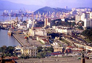
Port of Vladivostok
Port in Russia
Distance: Approx. 1436 meters
Latitude and longitude: 43.105,131.92166667
The Port of Vladivostok is a seaport in Vladivostok, Primorsky Krai, Russia.
Consulate General of the United States, Vladivostok
Diplomatic mission
Distance: Approx. 237 meters
Latitude and longitude: 43.11527778,131.90916667
Consulate General of the United States, Vladivostok (Russian: Генеральное консульство США во Владивостоке) was a diplomatic mission of the United States in Vladivostok, providing consular services to Russian and American citizens in the Far East and in Eastern Siberia. The consulate was located in the Leninsky District of Vladivostok, at Pushkinskaya Street, house 32. It was closed in 2021 due to staffing shortages.
Far Eastern State Institute of Arts
Distance: Approx. 1563 meters
Latitude and longitude: 43.11527778,131.89277778
Far Eastern State Institute of Arts (Russian: Дальневосточный государственный институт искусств) is a Russian state higher education institution located in the city of Vladivostok, Russia.
Weather in this IP's area
clear sky
6 Celsius
6 Celsius
6 Celsius
6 Celsius
1020 hPa
56 %
1020 hPa
1010 hPa
10000 meters
1.23 m/s
1.5 m/s
260 degree
07:17:24
18:42:07