Country:
 Russian Federation
Region:
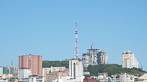
City:
Latitude and Longitude:
Time Zone:
Postal Code:
IP information under different IP Channel
ip-api
Country
Region
City
ASN
Time Zone
ISP
Blacklist
Proxy
Latitude
Longitude
Postal
Route
IPinfo
Country
Region
City
ASN
Time Zone
ISP
Blacklist
Proxy
Latitude
Longitude
Postal
Route
MaxMind
Country
Region
City
ASN
Time Zone
ISP
Blacklist
Proxy
Latitude
Longitude
Postal
Route
Luminati
Country
RUASN
Time Zone
Europe/Moscow
ISP
Rostelecom
Latitude
Longitude
Postal
db-ip
Country
Region
City
ASN
Time Zone
ISP
Blacklist
Proxy
Latitude
Longitude
Postal
Route
ipdata
Country
Region
City
ASN
Time Zone
ISP
Blacklist
Proxy
Latitude
Longitude
Postal
Route
Popular places and events near this IP address

Vladivostok State University of Economics and Service
University in Vladivostok, Russia
Distance: Approx. 1308 meters
Latitude and longitude: 43.1256,131.905
Vladivostok State University of Economics and Service (Russian: Владивосто́кский госуда́рственный университе́т эконо́мики и се́рвиса), or VSUES (ВГУЭС), is a university located in Vladivostok, Russia. Over 17 000 students from Russia and abroad study at VSUES. It has 68 bachelor's programs, 20 master's programs, 22 Ph.D. programs, and 8 technical programs. Programs are in areas as diverse as economics and business, design, management, tourism, engineering, and international studies.

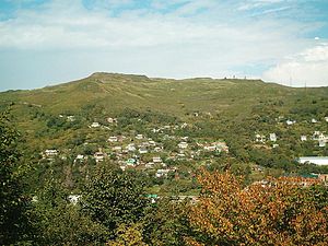
Primorskaya Oblast
Former Russian administrative division
Distance: Approx. 2378 meters
Latitude and longitude: 43.1167,131.9
Primorskaya Oblast (Russian: Примо́рская о́бласть) was an administrative division of the Russian Empire and the early Russian SFSR, created on October 31, 1856 by the Governing Senate. The name of the region literally means "Maritime" or "Coastal." The region was established upon a Russian conquest of Daur people that used to live along Amur River. Before the Russian conquest of Russian Manchuria, the territory belonged to the Chinese region of Manchuria.
Mount Kholodilnik
Mountain in Primorsky Krai, Russia
Distance: Approx. 2550 meters
Latitude and longitude: 43.14527778,131.94
Kholodilnik Mountain (Russian: гора́ Холоди́льник or со́пка Холодильник; lit. "Mt. Refrigerator", formerly Mount Muravyov-Amursky), is a mountain in eastern Russia.
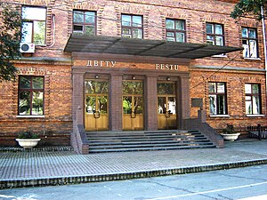
Far Eastern State Technical University
University in Russia
Distance: Approx. 2462 meters
Latitude and longitude: 43.1156,131.9011
Far Eastern State Technical University (FESTU) (Russian: Дальневосто́чный госуда́рственный техни́ческий университе́т, ДВГТУ) is a university located in Vladivostok, Russia. It was established on February 20, 1930 as Far Eastern Politechnical Institute (Дальневосточный политехнический институт (ДВПИ)). It was granted the university status in 1992.

Vladivostok State Medical University
Distance: Approx. 969 meters
Latitude and longitude: 43.13083333,131.90194444
Pacific State Medical University (Russian: Тихоокеанский государственный медицинский университет), formerly known as VSMU (Vladivostok State Medical University) is a university in Vladivostok in the Far East of Russia. At the beginning, since 1956 VSMU was the Medical Faculty of the Far Eastern State University, but in 2 years it became Vladivostok State Medical Institute (VSMU). Institute was re organized into the university in 1995, in 2013 the university was renamed and reorganized into Pacific State Medical University.
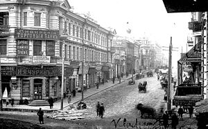
Svetlanskaya Street
Street in Vladivostok, Russia
Distance: Approx. 2712 meters
Latitude and longitude: 43.1125,131.9167
Svetlanskaya Street (Russian: Светла́нская у́лица, romanized: Svetlanskaya ulitsa) is a major street in Vladivostok, Russia.
Eagle's Nest Hill
Distance: Approx. 2110 meters
Latitude and longitude: 43.12083333,131.89638889
Eagle's Nest Hill (Russian: Орлиное Гнездо) is a hill in the Russian city of Vladivostok. Previously called Klykova, the peak was renamed in honour of the Russian troops who fought at Mt. St Nicholas in the Shipka Pass during the Russo-Turkish war of 1878.

Mother of God Church, Vladivostok
Church in Vladivostok, Russia
Distance: Approx. 2238 meters
Latitude and longitude: 43.1164,131.9114
The Mother of God Church (Russian: Церковь Пресвятой Богородицы) It is a Latin Catholic church, built in a Gothic style, located in Vladivostok in the Far East of Russia. It is the seat of the deanery of Vladivostok, which depends on the Diocese of Irkutsk. It is located at 22 Volodarsky Street.

Pacific Higher Naval School
Russian naval academy in Vladivostok
Distance: Approx. 688 meters
Latitude and longitude: 43.1425,131.91305556
The Makarov Pacific Higher Naval School (Russian: Тихоокеанское высшее военно-морское училище имени С. О. Макарова) is one of the Russian Navy's two higher educational institutions under the Ministry of Defense of Russia, with this school being located in Vladivostok in Eastern Russia, the only naval educational institution in this region. It serves as an naval officer commissioning school for officers in the Pacific Fleet. It is named after the accomplished Russian oceanographer and commander of the Imperial Russian Navy, Vice-Admiral Stepan Makarov.

Vladivostok Synagogue
Synagogue in Russia
Distance: Approx. 2568 meters
Latitude and longitude: 43.12266429,131.8857078
Bet Sima Synagogue or Vladivostok Synagogue (Russian : «Бейт Сима» ; Hebrew: בית סימה) is a Jewish synagogue in the Russian city of Vladivostok and the only synagogue in Primorsky Krai. It is the oldest continuously operating synagogue in the Russian Far East. The synagogue is located in the historic district of Vladivostok, on Praporchik Komarov St.
Consulate General of the United States, Vladivostok
Diplomatic mission
Distance: Approx. 2367 meters
Latitude and longitude: 43.11527778,131.90916667
Consulate General of the United States, Vladivostok (Russian: Генеральное консульство США во Владивостоке) was a diplomatic mission of the United States in Vladivostok, providing consular services to Russian and American citizens in the Far East and in Eastern Siberia. The consulate was located in the Leninsky District of Vladivostok, at Pushkinskaya Street, house 32. It was closed in 2021 due to staffing shortages.

Sinhanch'on
1911–1937 Korean enclave in Vladivostok
Distance: Approx. 1288 meters
Latitude and longitude: 43.135,131.89527778
Sinhanch'on was an enclave of Koreans in Vladivostok that existed between 1911 and 1937, during which time the city was controlled for periods by the Russian Empire, Far Eastern Republic and finally the Soviet Union. It holds an important place in the history of Koryo-saram (ethnic Koreans of the mainland former Soviet Union), and is now remembered as a hub of the Korean independence movement. It hosted the first Korean provisional government, the Korean Independence Army Government.
Weather in this IP's area
clear sky
15 Celsius
15 Celsius
15 Celsius
15 Celsius
1016 hPa
80 %
1016 hPa
1015 hPa
10000 meters
1.18 m/s
1.91 m/s
63 degree
06:45:23
19:34:24