Country:
 Russian Federation
Region:
City:
Latitude and Longitude:
Time Zone:
Postal Code:
IP information under different IP Channel
ip-api
Country
Region
City
ASN
Time Zone
ISP
Blacklist
Proxy
Latitude
Longitude
Postal
Route
IPinfo
Country
Region
City
ASN
Time Zone
ISP
Blacklist
Proxy
Latitude
Longitude
Postal
Route
MaxMind
Country
Region
City
ASN
Time Zone
ISP
Blacklist
Proxy
Latitude
Longitude
Postal
Route
Luminati
Country
RUASN
Time Zone
Europe/Moscow
ISP
Rostelecom
Latitude
Longitude
Postal
db-ip
Country
Region
City
ASN
Time Zone
ISP
Blacklist
Proxy
Latitude
Longitude
Postal
Route
ipdata
Country
Region
City
ASN
Time Zone
ISP
Blacklist
Proxy
Latitude
Longitude
Postal
Route
Popular places and events near this IP address

Dynamo Stadium (Vladivostok)
Multi-purpose stadium in Vladivostok, Russia
Distance: Approx. 4470 meters
Latitude and longitude: 43.1192,131.8788
The Dynamo Stadium is a multi-purpose stadium in Vladivostok, Russia. It is used mostly for football matches and is the home ground of FC Dynamo Vladivostok. The stadium is situated near the main square and harbour and by one of the beaches of Vladivostok.

Maritime State University
Maritime university in Russia
Distance: Approx. 2472 meters
Latitude and longitude: 43.10305556,131.86805556
Maritime State University (MSU) (Russian: Морско́й госуда́рственный университе́т и́мени адмира́ла Г.И. Невельско́го, romanized: G.I. Nevelskoi Maritime State University) is a maritime university in Vladivostok, Russia. It is named after G.I. Nevelskoi, in its full Russian name. The university aims to provide specialisation in maritime transport systems in the spheres of natural science, the humanities, technical and marine conventional trends.

Zolotoy Rog
Bay in Russia
Distance: Approx. 4530 meters
Latitude and longitude: 43.10833333,131.89861111
Zolotoy Rog (Russian: Золотой Рог) or the Golden Horn Bay, is a sheltered horn-shaped bay of the Sea of Japan, located in coastal Primorsky Krai within the Russian Far East. Vladivostok, which lies on the hills at the head of the bay, is a major city and Russian port on the Pacific.
Diomede Bay
Inlet of the Peter the Great Gulf, Vladivostok, Russia
Distance: Approx. 3520 meters
Latitude and longitude: 43.09,131.89722222
The Diomede Bay (Russian: бухта Диомид, also Diomid Bay or Diomedes Bay) is a landlocked inlet of the Peter the Great Gulf in the Russian city of Vladivostok. The bay derives its name from Diomedes, the first Russian brig to cast anchor in the bay back in 1862. The coastline is dotted with run-down fisheries, fishing wharves, and depots.

Eastern Bosphorus
Strait in the Sea of Japan, Russia
Distance: Approx. 4086 meters
Latitude and longitude: 43.06666667,131.9
The Eastern Bosphorus (Russian: Босфор Восточный, Bosfor Vostochny) is a strait located in Primorsky Krai, Russia, that separates the Muravyov-Amursky Peninsula and Russky Island, and connects Amur Bay and Ussuri Bay within Peter the Great Gulf. The Eastern Bosphorus has a depth of up to 50 meters (160 feet) and is about 9 kilometers (5.6 miles) long and only 800 meters (2,600 feet) wide at its narrowest point. The strait features several bays within the peninsula and Russky Island, including the major Zolotoy Rog bay.

Vladivostok
Largest city and administrative center of Primorsky Krai, Russia
Distance: Approx. 4330 meters
Latitude and longitude: 43.115,131.88527778
Vladivostok ( VLAD-iv-OST-ok; Russian: Владивосток, IPA: [vlədʲɪvɐˈstok] ) is the largest city and the administrative center of Primorsky Krai and the capital of the Far Eastern Federal District of Russia, located in the far east of Russia. It is located around the Golden Horn Bay on the Sea of Japan, covering an area of 331.16 square kilometers (127.86 square miles), with a population of 603,519 residents as of 2021. Vladivostok is the second-largest city in the Far Eastern Federal District, as well as the Russian Far East, after Khabarovsk.

Zolotoy Bridge
Bridge in Vladivostok, Russia
Distance: Approx. 4419 meters
Latitude and longitude: 43.10902,131.896058
The Zolotoy Bridge (Russian: Золотой мост, lit. 'Golden Bridge') is a cable-stayed bridge across the Zolotoy Rog (Golden Horn Bay) in Vladivostok, Russia. The Zolotoy Rog Bridge was one of two bridges, along with the Russky Island Bridge, built in preparation for the 2012 APEC summit. The bridge was commissioned by the city of Vladivostok in 2006.

Kunst and Albers
Former German trading company in Russia
Distance: Approx. 4499 meters
Latitude and longitude: 43.1155,131.8879
Kunst and Albers (German: Kunst und Albers, Russian: Кунст и Альберс) or Kunst & Albers was a German trading company in Russia. Founded by Gustav Kunst, a merchant, and Gustav Albers, a sailor, it operated the first department store in Vladivostok. At its height, it was a vast business empire and the largest trading company in the Russian Far East.

Soviet submarine S-56
Distance: Approx. 4487 meters
Latitude and longitude: 43.11342,131.891221
S-56 was an S-class submarine of the Soviet Navy during and after World War II. She was laid down by shipyard #194 in Leningrad on 24 November 1936, shipped in sections by rail to Vladivostok where it was reassembled by Dalzavod. She was launched on 25 December 1939 and commissioned on 20 October 1941 in the Pacific Fleet. During World War II, the submarine was under the command of Captain Grigori Shchedrin and was moved from the Pacific Fleet to the Northern fleet across the Pacific and Atlantic Oceans via the Panama Canal.

Vladivostok railway station
Railway station in Vladivostok, Russia
Distance: Approx. 3806 meters
Latitude and longitude: 43.11116111,131.88155
Vladivostok railway station is a railway station in Vladivostok, Russia. It is the eastern terminus of the Trans-Siberian Railway. Also, Aeroexpress (Express Primorya) from this station to Vladivostok International Airport (Knevichi Railway Station) are operated.
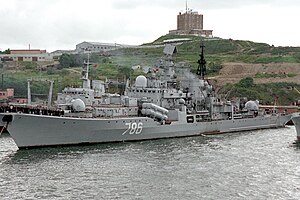
Russian destroyer Bystry
Sovremenny-class destroyer of the Russian Navy
Distance: Approx. 4178 meters
Latitude and longitude: 43.1118729,131.8878362
Bystry was a Sovremenny-class destroyer of the Soviet and later Russian navy.

Vladimir K. Arseniev Museum of Far East History
Museum in Vladivostok, Russia
Distance: Approx. 4312 meters
Latitude and longitude: 43.11627778,131.88213889
The Vladimir K. Arseniev Museum of Far East History (Russian: Музей истории Дальнего Востока имени В. К. Арсеньева) is a museum named after the explorer, Vladimir Arseniev, in the city of Vladivostok in the Russian Far East. The museum's collections focus on the history of Vladivostok and the surrounding area in Primorsky Krai. The Vladimir K. Arseniev Museum of Far East History also manages the museum facilities at Vladivostok Fortress.
Weather in this IP's area
clear sky
15 Celsius
14 Celsius
15 Celsius
15 Celsius
1016 hPa
80 %
1016 hPa
1011 hPa
10000 meters
1.48 m/s
2.28 m/s
43 degree
06:45:39
19:34:35