Country:
 Netherlands
Region:
City:
Latitude and Longitude:
Time Zone:
Postal Code:
IP information under different IP Channel
ip-api
Country
Region
City
ASN
Time Zone
ISP
Blacklist
Proxy
Latitude
Longitude
Postal
Route
IPinfo
Country
Region
City
ASN
Time Zone
ISP
Blacklist
Proxy
Latitude
Longitude
Postal
Route
MaxMind
Country
Region
City
ASN
Time Zone
ISP
Blacklist
Proxy
Latitude
Longitude
Postal
Route
Luminati
Country
NLRegion
ut
City
abcoude
ASN
Time Zone
Europe/Amsterdam
ISP
DELTA Fiber Nederland B.V.
Latitude
Longitude
Postal
db-ip
Country
Region
City
ASN
Time Zone
ISP
Blacklist
Proxy
Latitude
Longitude
Postal
Route
ipdata
Country
Region
City
ASN
Time Zone
ISP
Blacklist
Proxy
Latitude
Longitude
Postal
Route
Popular places and events near this IP address
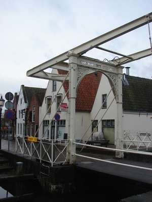
Abcoude
Town and former municipality in Utrecht, Netherlands
Distance: Approx. 342 meters
Latitude and longitude: 52.27,4.97
Abcoude (Dutch pronunciation: [ɑpˈkʌudə] ) is a town and former municipality in the Netherlands, in the province of Utrecht. Since 2011 it has been part of the municipality of De Ronde Venen.

Nigtevecht
Village in Utrecht, Netherlands
Distance: Approx. 3629 meters
Latitude and longitude: 52.27416667,5.02777778
Nigtevecht (Dutch pronunciation: [ˈnɪxtəˌvɛxt]) is a village in the province of Utrecht, Netherlands with a population of 1,395. Formerly part of the municipality of Loenen; it has been part of the newly-formed municipality of Stichtse Vecht since 2011. It is situated about 9 km (5.6 mi) west of Bussum along the Vecht River in the Vechtstreek.
Baambrugge
Town in Utrecht, Netherlands
Distance: Approx. 2785 meters
Latitude and longitude: 52.24611111,4.98861111
Baambrugge is a village on the river Angstel in the Dutch province of Utrecht. It is a part of the municipality of De Ronde Venen and lies about 14 km southeast of Amsterdam. In 2001 the village of Baambrugge had 925 inhabitants.

Vinkenkade
Hamlet in Utrecht, Netherlands
Distance: Approx. 2924 meters
Latitude and longitude: 52.24361111,4.97
Vinkenkade is a hamlet in the Dutch province of Utrecht. It is located in the municipality of De Ronde Venen, about 5 km northeast of Vinkeveen. Vinkenkade consists of a single road, parallel to the A2 highway Amsterdam-Utrecht.

Stokkelaarsbrug
Hamlet in Utrecht, Netherlands
Distance: Approx. 3074 meters
Latitude and longitude: 52.2687,4.9299
Stokkelaarsbrug is a hamlet in the Dutch province of Utrecht. It is a part of the municipality of De Ronde Venen, and lies about 12 km south of Amsterdam. It is located on the border with the province North Holland, where the small river Winkel joins the Oude Waver.
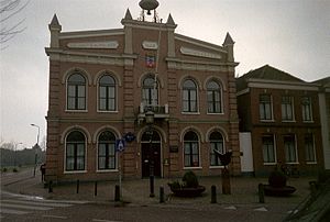
Abcoude-Proostdij
Distance: Approx. 399 meters
Latitude and longitude: 52.27083333,4.98055556
Abcoude-Proostdij (sometimes called "Abcoude-Proosdij" or "Abcoude-Proostdij en Aasdom") is a former municipality in the Dutch province of Utrecht. Abcoude-Proostdij covered the northern part of the current municipality of Abcoude, including the village of Abcoude itself. Abcoude-Proostdij was a heerlijkheid (manor) owned by the chapter of the St.

Academic Medical Center (Amsterdam)
Hospital in Amsterdam, Netherlands
Distance: Approx. 3001 meters
Latitude and longitude: 52.29444444,4.9575
The Academic Medical Center (Dutch: Academisch Medisch Centrum), or AMC, was the university hospital affiliated with the University of Amsterdam. After merging with the VU University Medical Center, it now operates as the Amsterdam University Medical Center, a single organization with two locations, affiliated with two universities. It was one of the largest and leading hospitals of the Netherlands, located in the Bijlmer neighborhood in the most south-eastern part of the city of Amsterdam.

Amsterdam Holendrecht station
Metro and railway station in Amsterdam
Distance: Approx. 3259 meters
Latitude and longitude: 52.2975,4.96
Amsterdam Holendrecht is a railway and metro station in Amsterdam, Netherlands. The station opened on 14 December 2008. Before that date Holendrecht was just a station on the Amsterdam Metro network which was opened on 16 October 1977 and is now served by two lines, the 50 and 54.
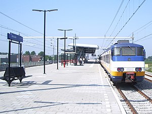
Abcoude railway station
Railway station in Abcoude, the Netherlands
Distance: Approx. 722 meters
Latitude and longitude: 52.27444444,4.98222222
Abcoude is a railway station located in Abcoude, Netherlands.

Reigersbos metro station
Metro station in Amsterdam, Netherlands
Distance: Approx. 2878 meters
Latitude and longitude: 52.29555556,4.97444444
Reigersbos is an Amsterdam Metro station in the Gaasperdam area of Amsterdam, Netherlands. The station opened in 1982 and is served by 2 lines, the 50 (Isolatorweg - Gein) and 54 (Amsterdam Centraal - Gein). The metro station is only accessible with an OV-chipkaart, GVB Travel Pass or paying by cash.

Gein metro station
Metro station in Amsterdam, Netherlands
Distance: Approx. 3124 meters
Latitude and longitude: 52.29638889,4.98916667
Gein is an Amsterdam Metro station in the Gaasperdam area of Amsterdam, Netherlands. The station opened in 1982 and is served by 2 lines, the 50 (Isolatorweg - Gein) and 54 (Amsterdam Centraal - Gein). The metro station is only accessible with an OV-chipkaart or GVB Travel Pass.

Angstel River
Distance: Approx. 4047 meters
Latitude and longitude: 52.2369,5.0006
The Angstel is a small river between Abcoude and Loenersloot in the Netherlands, about halfway between Amsterdam and Utrecht. The Angstel is about 6 km (3.75 mi) long and connects the Gein and Holendrecht rivers with the Aa and Winkel rivers. East of the Angstel is the Amsterdam–Rhine Canal.
Weather in this IP's area
clear sky
5 Celsius
5 Celsius
3 Celsius
7 Celsius
1020 hPa
98 %
1020 hPa
1020 hPa
9000 meters
0.51 m/s
70 degree
07:48:15
19:08:23