Country:
 Netherlands
Region:
City:
Latitude and Longitude:
Time Zone:
Postal Code:
IP information under different IP Channel
ip-api
Country
Region
City
ASN
Time Zone
ISP
Blacklist
Proxy
Latitude
Longitude
Postal
Route
IPinfo
Country
Region
City
ASN
Time Zone
ISP
Blacklist
Proxy
Latitude
Longitude
Postal
Route
MaxMind
Country
Region
City
ASN
Time Zone
ISP
Blacklist
Proxy
Latitude
Longitude
Postal
Route
Luminati
Country
NLRegion
ut
City
ijsselstein
ASN
Time Zone
Europe/Amsterdam
ISP
DELTA Fiber Nederland B.V.
Latitude
Longitude
Postal
db-ip
Country
Region
City
ASN
Time Zone
ISP
Blacklist
Proxy
Latitude
Longitude
Postal
Route
ipdata
Country
Region
City
ASN
Time Zone
ISP
Blacklist
Proxy
Latitude
Longitude
Postal
Route
Popular places and events near this IP address

IJsselstein
City and Municipality in Utrecht, Netherlands
Distance: Approx. 894 meters
Latitude and longitude: 52.01666667,5.03333333
IJsselstein (Dutch pronunciation: [ˈɛisəlstɛin] ) is a municipality and city in the Netherlands, in the province of Utrecht. IJsselstein received city rights in 1331. IJsselstein owes its name to the river Hollandse IJssel which flows through the city.

Nieuwegein
Municipality in Utrecht, Netherlands
Distance: Approx. 4129 meters
Latitude and longitude: 52.03333333,5.08333333
Nieuwegein (Dutch pronunciation: [ˌniu.əˈɣɛin] ) is a municipality and city in the Dutch province of Utrecht. It is bordered on the north by the city of Utrecht, the provincial capital. It is separated from Vianen to the south by the river Lek and borders on IJsselstein in the southwest and Houten in the east.

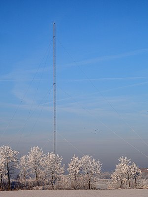
Gerbrandy Tower
Partially guyed tower in Utrecht province, the Netherlands
Distance: Approx. 1093 meters
Latitude and longitude: 52.01006667,5.053575
The Gerbrandy Tower (Dutch: Gerbrandytoren) is a radio tower in IJsselstein, the Netherlands. It is also known as Lopik tower after the nearby town. It was built in 1961.
Mediumwave transmitter Lopik
Radio mast in the Netherlands, 1938–2015
Distance: Approx. 1075 meters
Latitude and longitude: 52.00055556,5.045
The Mediumwave transmitter Lopik was a medium wave broadcasting facility near Lopik in the Netherlands. It was constructed in 1938 (1938) and destroyed on September 1, 2015 (2015-09-01). Its last use was to transmit the Dutch language edition of Radio Maria on 675 kHz.

Benschop, Utrecht
Village in Utrecht, Netherlands
Distance: Approx. 3997 meters
Latitude and longitude: 52.00722222,4.97944444
Benschop is a village in the Dutch province of Utrecht. It is a part of the municipality of Lopik, and lies about 4 km west of IJsselstein. Benschop is an extremely long village: apart from a relatively compact town centre, it consists of a long ribbon (over 8 km long) of houses (mainly farms) on both sides of the Benschopsche Wetering.
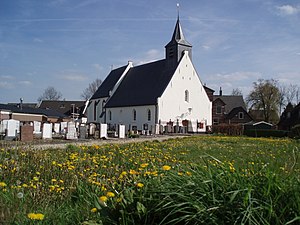
Lopikerkapel
Village in Utrecht, Netherlands
Distance: Approx. 2018 meters
Latitude and longitude: 51.99194444,5.04722222
Lopikerkapel is a village in the Dutch province of Utrecht. It is a part of the municipality of Lopik, and lies about 3 km south of IJsselstein. The village has a small centre, with a church, but mostly consists of a ribbon of farms on both sides of the Enge IJssel river.
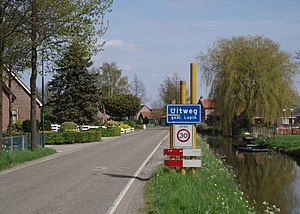
Uitweg
Hamlet in Utrecht, Netherlands
Distance: Approx. 3363 meters
Latitude and longitude: 51.9825,5.01444444
Uitweg is a hamlet in the Dutch province of Utrecht. It is a part of the municipality of Lopik, and lies about 5 km southwest of IJsselstein. The town consists almost completely of a ribbon of farms along the Enge IJssel and Lopiker Wetering rivers, between Graaf and Lopikerkapel.

Jutphaas
Former municipality in Utrecht, Netherlands
Distance: Approx. 4129 meters
Latitude and longitude: 52.03333333,5.08333333
Jutphaas is a former village and municipality in the province of Utrecht in the Netherlands. The municipality merged with Vreeswijk in 1971, and is now the northern half of the town of Nieuwegein. The former village was located on the Merwedekanaal, and some of the buildings can still be found there, surrounded by the suburbs of Nieuwegein.

Kortenhoeven
Hamlet in Utrecht, Netherlands
Distance: Approx. 4343 meters
Latitude and longitude: 51.97055556,5.0475
Kortenhoeven is a hamlet in the Dutch province of Utrecht. It is a part of the municipality of Vijfheerenlanden, and lies about 5 km south of IJsselstein. The hamlet was first mentioned around 1343 as Cortenhover, and means short river bank.

Vijfheerenlanden
Municipality in Utrecht, Netherlands
Distance: Approx. 4388 meters
Latitude and longitude: 52,5.1
Vijfheerenlanden (Dutch pronunciation: [ˈvɛi̯fˌɦeːrə(n)ˌlɑndə(n)]), literally "lands of five Lords", is a municipality in the province of Utrecht in the Netherlands. The municipality was created on 1 January 2019 through the merger of the former municipalities of Vianen (Utrecht), Leerdam and Zederik (both South Holland). Vijfheerenlanden has 59,150 inhabitants on 1 January 2022.

Utrechtse sneltram
Rapid transit railway in Utrecht, Netherlands
Distance: Approx. 43 meters
Latitude and longitude: 52.0092,5.0383
The Utrechtse sneltram (Dutch pronunciation: [ˈytrɛxtsə ˈsnɛltrɛm]; literally Utrecht fast tram), operating under the brand name U-OV, is a light rail system in the Dutch city of Utrecht. The system consists of three tram routes connecting Utrecht Centraal railway station with the residential areas of Lombok and Kanaleneiland and the suburbs Nieuwegein and IJsselstein to the southwest of the station, and with the Uithof district and Utrecht University to the southeast.

Nieuwegein City (tram stop)
Tram stop in Nieuwegein, the Netherlands
Distance: Approx. 3597 meters
Latitude and longitude: 52.0289,5.0792
Nieuwegein City (formerly Stadscentrum) is a tram stop of the Utrecht sneltram network, located beside the Nieuwegein Cityplaza shopping mall in Nieuwegein. It is along the SUNIJ (sneltram Utrecht-Nieuwegein-IJsselstein) line which runs south from the Jaarbeursplein and Centrumzijde stops at Utrecht Centraal railway station. South of the Nieuwegein City stop is the main junction of the sneltram network where southbound trams from Utrecht branch to either IJsselstein-Zuid and Nieuwegein-Zuid, tram routes 20 and 21 respectively.
Weather in this IP's area
clear sky
4 Celsius
3 Celsius
3 Celsius
7 Celsius
1020 hPa
95 %
1020 hPa
1020 hPa
10000 meters
1.73 m/s
1.71 m/s
112 degree
07:47:46
19:08:20