Country:
 Netherlands
Region:
City:
Latitude and Longitude:
Time Zone:
Postal Code:
IP information under different IP Channel
ip-api
Country
Region
City
ASN
Time Zone
ISP
Blacklist
Proxy
Latitude
Longitude
Postal
Route
IPinfo
Country
Region
City
ASN
Time Zone
ISP
Blacklist
Proxy
Latitude
Longitude
Postal
Route
MaxMind
Country
Region
City
ASN
Time Zone
ISP
Blacklist
Proxy
Latitude
Longitude
Postal
Route
Luminati
Country
NLRegion
ut
City
nieuwegein
ASN
Time Zone
Europe/Amsterdam
ISP
DELTA Fiber Nederland B.V.
Latitude
Longitude
Postal
db-ip
Country
Region
City
ASN
Time Zone
ISP
Blacklist
Proxy
Latitude
Longitude
Postal
Route
ipdata
Country
Region
City
ASN
Time Zone
ISP
Blacklist
Proxy
Latitude
Longitude
Postal
Route
Popular places and events near this IP address

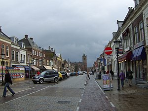
Nieuwegein
Municipality in Utrecht, Netherlands
Distance: Approx. 3016 meters
Latitude and longitude: 52.03333333,5.08333333
Nieuwegein (Dutch pronunciation: [ˌniu.əˈɣɛin] ) is a municipality and city in the Dutch province of Utrecht. It is bordered on the north by the city of Utrecht, the provincial capital. It is separated from Vianen to the south by the river Lek and borders on IJsselstein in the southwest and Houten in the east.
Vianen
City and former municipality in Utrecht, Netherlands
Distance: Approx. 906 meters
Latitude and longitude: 52,5.1
Vianen (Dutch pronunciation: [viˈjaːnə(n)] ) is a city and a former municipality in the central Netherlands, in the province of Utrecht. It is located south of the Lek river. Before 2002 it was part of the province of South Holland.

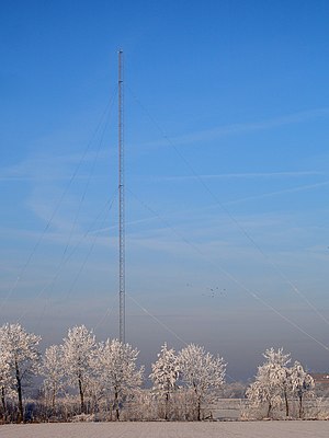
Gerbrandy Tower
Partially guyed tower in Utrecht province, the Netherlands
Distance: Approx. 2724 meters
Latitude and longitude: 52.01006667,5.053575
The Gerbrandy Tower (Dutch: Gerbrandytoren) is a radio tower in IJsselstein, the Netherlands. It is also known as Lopik tower after the nearby town. It was built in 1961.

Hagestein
Village in Utrecht, Netherlands
Distance: Approx. 3567 meters
Latitude and longitude: 51.97972222,5.12055556
Hagestein is a village and former city in the municipality of Vijfheerenlanden, Utrecht, Netherlands, on the Lek River, about 2 km east of Vianen. It received city rights in 1382. Hagestein was destroyed in 1405 by the Count of Holland and the Prince-Bishop of Utrecht.
Mediumwave transmitter Lopik
Radio mast in the Netherlands, 1938–2015
Distance: Approx. 3364 meters
Latitude and longitude: 52.00055556,5.045
The Mediumwave transmitter Lopik was a medium wave broadcasting facility near Lopik in the Netherlands. It was constructed in 1938 (1938) and destroyed on September 1, 2015 (2015-09-01). Its last use was to transmit the Dutch language edition of Radio Maria on 675 kHz.
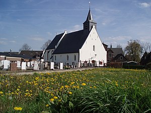
Lopikerkapel
Village in Utrecht, Netherlands
Distance: Approx. 3552 meters
Latitude and longitude: 51.99194444,5.04722222
Lopikerkapel is a village in the Dutch province of Utrecht. It is a part of the municipality of Lopik, and lies about 3 km south of IJsselstein. The village has a small centre, with a church, but mostly consists of a ribbon of farms on both sides of the Enge IJssel river.

Jutphaas
Former municipality in Utrecht, Netherlands
Distance: Approx. 3016 meters
Latitude and longitude: 52.03333333,5.08333333
Jutphaas is a former village and municipality in the province of Utrecht in the Netherlands. The municipality merged with Vreeswijk in 1971, and is now the northern half of the town of Nieuwegein. The former village was located on the Merwedekanaal, and some of the buildings can still be found there, surrounded by the suburbs of Nieuwegein.

Vreeswijk
District in Nieuwegijn, Netherlands, former municipality
Distance: Approx. 906 meters
Latitude and longitude: 52,5.1
Vreeswijk is a former village and municipality in the Dutch province of Utrecht. The municipality merged with Jutphaas in 1971, and is now the southern half of the town of Nieuwegein. The former village was located on the Lek River, near where it is crossed by the Merwede Canal.

Tull en 't Waal
Village in Utrecht, Netherlands
Distance: Approx. 2834 meters
Latitude and longitude: 52.00055556,5.13305556
Tull en 't Waal is a village in the Dutch province of Utrecht. Until 1962, it was a separate municipality, but now it is a part of the municipality of Houten. Originally, there were two villages: 't Waal, at the site of the present village; and Tull, more to the south.

Vijfheerenlanden
Municipality in Utrecht, Netherlands
Distance: Approx. 906 meters
Latitude and longitude: 52,5.1
Vijfheerenlanden (Dutch pronunciation: [ˈvɛi̯fˌɦeːrə(n)ˌlɑndə(n)]), literally "lands of five Lords", is a municipality in the province of Utrecht in the Netherlands. The municipality was created on 1 January 2019 through the merger of the former municipalities of Vianen (Utrecht), Leerdam and Zederik (both South Holland). Vijfheerenlanden has 59,150 inhabitants on 1 January 2022.

Kasteel Heemstede
Restaurant in Houten, Netherlands
Distance: Approx. 3644 meters
Latitude and longitude: 52.033,5.1251
Kasteel Heemstede is a restaurant in Houten, Netherlands. It is a fine dining restaurant that was awarded one Michelin star for the periods 2003-2008 and 2011–present. The restaurant is located in the souterrain of the eponymous castle, although it was in fact an buitenplaats.

Nieuwegein City (tram stop)
Tram stop in Nieuwegein, the Netherlands
Distance: Approx. 2625 meters
Latitude and longitude: 52.0289,5.0792
Nieuwegein City (formerly Stadscentrum) is a tram stop of the Utrecht sneltram network, located beside the Nieuwegein Cityplaza shopping mall in Nieuwegein. It is along the SUNIJ (sneltram Utrecht-Nieuwegein-IJsselstein) line which runs south from the Jaarbeursplein and Centrumzijde stops at Utrecht Centraal railway station. South of the Nieuwegein City stop is the main junction of the sneltram network where southbound trams from Utrecht branch to either IJsselstein-Zuid and Nieuwegein-Zuid, tram routes 20 and 21 respectively.
Weather in this IP's area
moderate rain
15 Celsius
15 Celsius
14 Celsius
16 Celsius
996 hPa
93 %
996 hPa
996 hPa
10000 meters
5.09 m/s
12.31 m/s
148 degree
100 %
07:52:37
19:01:16