Country:
 Netherlands
Region:
City:
Latitude and Longitude:
Time Zone:
Postal Code:
IP information under different IP Channel
ip-api
Country
Region
City
ASN
Time Zone
ISP
Blacklist
Proxy
Latitude
Longitude
Postal
Route
IPinfo
Country
Region
City
ASN
Time Zone
ISP
Blacklist
Proxy
Latitude
Longitude
Postal
Route
MaxMind
Country
Region
City
ASN
Time Zone
ISP
Blacklist
Proxy
Latitude
Longitude
Postal
Route
Luminati
Country
NLRegion
dr
City
schipborg
ASN
Time Zone
Europe/Amsterdam
ISP
DELTA Fiber Nederland B.V.
Latitude
Longitude
Postal
db-ip
Country
Region
City
ASN
Time Zone
ISP
Blacklist
Proxy
Latitude
Longitude
Postal
Route
ipdata
Country
Region
City
ASN
Time Zone
ISP
Blacklist
Proxy
Latitude
Longitude
Postal
Route
Popular places and events near this IP address

Zuidlaardermarkt
Distance: Approx. 2842 meters
Latitude and longitude: 53.0936,6.6869
The Zuidlaardermarkt (Dutch: Market of Zuidlaren) is an annual horse and country market in Zuidlaren, Netherlands. It is held on the third Tuesday in October. The horse market is the largest in Europe.

Zuidlaren
Place in Drenthe, Netherlands
Distance: Approx. 2821 meters
Latitude and longitude: 53.09416667,6.68444444
Zuidlaren (Noordenvelds: Zuudlaoren) is a village in the province of Drenthe in the Northern Netherlands. Zuidlaren has just over 10,000 inhabitants and is situated on natural heightened land which is called the Hondsrug. The village is part of the municipality of Tynaarlo.
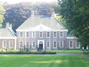
Laarwoud
Manor house in Drenthe, Netherlands
Distance: Approx. 3164 meters
Latitude and longitude: 53.0959,6.6899
Laarwoud is a monumental stronghold in the centre of Zuidlaren, the Netherlands. People also describe Laarwoud as a little castle, in the Netherlands locally known as havezate (Dutch). The word havezate is used in the Dutch provinces of Drenthe and Overijssel.

Schipborg
Village in Drenthe, Netherlands
Distance: Approx. 414 meters
Latitude and longitude: 53.07444444,6.66944444
Schipborg is a village in the Dutch province of Drenthe. It is a part of the municipality of Aa en Hunze, and lies about 11 km northeast of Assen. The village was first mentioned between 1298 and 1304 as Borc, and is a combination of a tree (probably a birch) and ship.

Zeegse
Village in Drenthe, Netherlands
Distance: Approx. 1187 meters
Latitude and longitude: 53.06666667,6.65
Zeegse is a village in the Dutch province of Drenthe. It is a part of the municipality of Tynaarlo, and lies about 9 km northeast of Assen. The village was first mentioned in 1225 as Otto de Segese.
Oudemolen, Drenthe
Hamlet in Drenthe, Netherlands
Distance: Approx. 3075 meters
Latitude and longitude: 53.04916667,6.63861111
Oudemolen is a hamlet in the Dutch province of Drenthe. It is a part of the municipality of Tynaarlo. Historically, the hamlet of Oude Molen was almost solely owned by the Linthorst Homan family, who have always held close ties with the towns population.

Prins Bernhardhoeve
Distance: Approx. 2869 meters
Latitude and longitude: 53.09305556,6.68916667
The Prins Bernhardhoeve (PBHZ) was a building complex for fairs and events in Zuidlaren, Netherlands. Opened in 1956, the complex consisted of three halls which were all named after members of the Dutch royal family. The largest hall was the Prince Constantijn hall, situated next to main entrance of the building.

Drentsche Aa National Park
Distance: Approx. 2609 meters
Latitude and longitude: 53.05,6.65
National Park Drentsche Aa is a national park of the Netherlands located in the province of Drenthe on the west side of the Hondsrug. It consists of the cultural landscape surrounding the valley of the small river the Drentsche Aa. The landscape is currently nearly the same as it was in the mid 19th century, as the several agricultural landscape reforms of the 20th century were not implemented in this area.
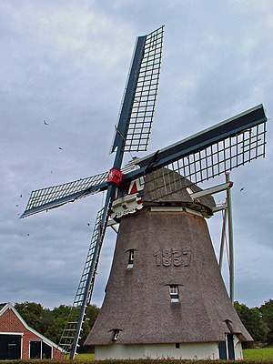
De Zwaluw, Oudemolen
Dutch windmill
Distance: Approx. 2420 meters
Latitude and longitude: 53.05371944,6.64486389
De Zwaluw (English: The Swallow) is a smock mill in Oudemolen, Drenthe, the Netherlands. It was built in 1837 and is listed as a Rijksmonument, number 38148.
De Vlindertuin
Restaurant in Zuidlaren, Netherlands
Distance: Approx. 2522 meters
Latitude and longitude: 53.09236944,6.68016667
De Vlindertuin is a restaurant located in Zuidlaren in the Netherlands. It is a fine dining restaurant that was awarded one Michelin star from 2008 to present. GaultMillau awarded the restaurant 15.0 out of 20 points.
Les Quatre Saisons
Restaurant in Zuidlaren, Netherlands
Distance: Approx. 2522 meters
Latitude and longitude: 53.09236944,6.68016667
Restaurant Les Quatre Saisons is a defunct restaurant in Zuidlaren, in the Netherlands. It was a fine dining restaurant that was awarded one Michelin star in 1981 and retained that rating until 1985. The restaurant closed before 1993, as the Michelin Guide mentioned the later also starred restaurant De Vlindertuin at that address.

Strubben–Kniphorstbos
Distance: Approx. 1723 meters
Latitude and longitude: 53.0618,6.6861
The Strubben–Kniphorstbos is a nature reserve of 377 hectares, located between Anloo and Schipborg in the Dutch province of Drenthe. It is the only archaeological reserve in the Netherlands. The park's composite name is derived from the 'stubby' oaks in the area, and by Gerrit Kniphorst, who was in the 19th century the owner of the then heathlands.
Weather in this IP's area
clear sky
4 Celsius
3 Celsius
3 Celsius
4 Celsius
1021 hPa
91 %
1021 hPa
1020 hPa
10000 meters
1.44 m/s
1.5 m/s
147 degree
07:42:06
19:00:58